Sainte-Marie-du-Mont, Isère
Sainte-Marie-du-Mont, Isère is a commune in the Isère department in southeastern France.
Sainte-Marie-du-Mont | |
|---|---|
_vue_g%C3%A9n%C3%A9rale.JPG) A general view of Sainte-Marie-du-Mont | |
Location of Sainte-Marie-du-Mont 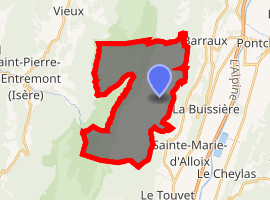
| |
 Sainte-Marie-du-Mont  Sainte-Marie-du-Mont | |
| Coordinates: 45°24′25″N 5°56′47″E | |
| Country | France |
| Region | Auvergne-Rhône-Alpes |
| Department | Isère |
| Arrondissement | Grenoble |
| Canton | Le Haut-Grésivaudan |
| Intercommunality | CC Le Grésivaudan |
| Government | |
| • Mayor (2014–2020) | Robert Monnet |
| Area 1 | 24 km2 (9 sq mi) |
| Population (2017-01-01)[1] | 237 |
| • Density | 9.9/km2 (26/sq mi) |
| Time zone | UTC+01:00 (CET) |
| • Summer (DST) | UTC+02:00 (CEST) |
| INSEE/Postal code | 38418 /38660 |
| Elevation | 522–1,880 m (1,713–6,168 ft) (avg. 934 m or 3,064 ft) |
| 1 French Land Register data, which excludes lakes, ponds, glaciers > 1 km2 (0.386 sq mi or 247 acres) and river estuaries. | |
Population
| Year | Pop. | ±% |
|---|---|---|
| 1800 | 377 | — |
| 1806 | 385 | +2.1% |
| 1821 | 404 | +4.9% |
| 1831 | 408 | +1.0% |
| 1841 | 526 | +28.9% |
| 1851 | 465 | −11.6% |
| 1861 | 382 | −17.8% |
| 1872 | 325 | −14.9% |
| 1881 | 229 | −29.5% |
| 1891 | 216 | −5.7% |
| 1901 | 192 | −11.1% |
| 1911 | 154 | −19.8% |
| 1921 | 107 | −30.5% |
| 1931 | 113 | +5.6% |
| 1946 | 90 | −20.4% |
| 1954 | 86 | −4.4% |
| 1962 | 57 | −33.7% |
| 1968 | 42 | −26.3% |
| 1990 | 116 | +176.2% |
| 1999 | 204 | +75.9% |
| 2006 | 212 | +3.9% |
| 2011 | 241 | +13.7% |
gollark: Or app, if you're weird.
gollark: Just close and reopen the tab.
gollark: <@319753218592866315> You are bad. Unslowmode it or die.
gollark: Γοογλε.
gollark: *ὀρ ἐλσε.*
See also
References
- "Populations légales 2017". INSEE. Retrieved 6 January 2020.
| Wikimedia Commons has media related to Sainte-Marie-du-Mont (Isère). |
| Authority control |
|
|---|
This article is issued from Wikipedia. The text is licensed under Creative Commons - Attribution - Sharealike. Additional terms may apply for the media files.