Biviers
Biviers (French pronunciation: [ˈbivje]) is a commune in the Isère département in southeastern France.
Biviers | |
|---|---|
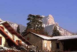 Biviers houses with Dent de Crolles in the background, 2009 | |
.svg.png) Flag | |
Location of Biviers 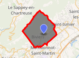
| |
 Biviers  Biviers | |
| Coordinates: 45°14′25″N 5°48′14″E | |
| Country | France |
| Region | Auvergne-Rhône-Alpes |
| Department | Isère |
| Arrondissement | Grenoble |
| Canton | Meylan |
| Intercommunality | CC Le Grésivaudan |
| Government | |
| • Mayor (2008–2014) | Jannick Moussin |
| Area 1 | 6.17 km2 (2.38 sq mi) |
| Population (2017-01-01)[1] | 2,386 |
| • Density | 390/km2 (1,000/sq mi) |
| Time zone | UTC+01:00 (CET) |
| • Summer (DST) | UTC+02:00 (CEST) |
| INSEE/Postal code | 38045 /38330 |
| Elevation | 311–1,388 m (1,020–4,554 ft) (avg. 417 m or 1,368 ft) |
| 1 French Land Register data, which excludes lakes, ponds, glaciers > 1 km2 (0.386 sq mi or 247 acres) and river estuaries. | |
Geography
Biviers lies 10 km (6.2 mi) northeast of Grenoble on the D1090 road, at the foot of Mount Saint-Eynard, on a limestone scree located on the east side of the Chartreuse mountains.
Towards the southwest, Biviers faces the Belledonne range, in the Grésivaudan section of the Isère valley. On the northwest, the village leans against a 450 metres (1,476 ft) tall limestone cliff above the scree. The cliff is subject to constant erosion, and rock slides are frequent during the summer, with great noise and much dust.[2]
Mout Blanc can be seen from many places in the village and is only 105 kilometres (65 mi) in line of sight.
Biviers can be subdivided into three main sectors:
- The upper part is a cliff starting from an elevation of 900 metres (2,953 ft) and culminating at 1,358 metres (4,455 ft).
- The middle section – between 500 metres (1,640 ft) and 900 metres (2,953 ft) – is a forest and is a favorite destination of hikers. The slope is steep and averages 20%. This section is sparsely populated.
- The lower section sits on flatter ground and is where most inhabitants live, the lowest point of the village being at 311 metres (1,020 ft).
Administration
Jannick Moussin is the current mayor of Biviers. She is assisted by:
- Jean-Claude Becquaert: 1st counselor
- Agnès Simon: 2nd counselor
- Jean-Philippe Raguin: 3rd counselor
- Thierry Ferotin: 4th counselor
- René Gautheron: 5th counselor
Other counselors are:- Eric Bernardon
- Eric Bouvier
- Catherine Cœur
- Marie-Thérèse Couture
- Frank Debaecker
- Béatrice Denise
- Gilbert Goncalves
- Robert Guyon
- Joëlle Martin-Borret
- Claude Sénéchal
- Lucien Vullierme
Biviers is a member of the intercommunality French: communauté de communes du Pays du Grésivaudan as of 1 January 2009.[3]
Population
The inhabitants of Biviers are known as French: Biviérois (pronounced [ˈbivjeʁwa]). From 1999 to 2007, the birth rate was 0.81% vs. a mortality rate of 0.55%.[4] Despite the positive difference, population decreased on average by 0.2% per year during the same period.
| Year | Pop. | ±% |
|---|---|---|
| 1962 | 679 | — |
| 1968 | 964 | +42.0% |
| 1975 | 1,733 | +79.8% |
| 1982 | 2,147 | +23.9% |
| 1990 | 2,258 | +5.2% |
| 1999 | 2,385 | +5.6% |
| 2009 | 2,354 | −1.3% |
The 2005 census[5] showed that women represent 50.5% of Biviers' population versus 49.5% for men. This population is aging fairly fast:[6]
| age | 0 – 19 | 20 – 39 | 40 – 59 | 60 + |
|---|---|---|---|---|
| men 1999 | 28.2% | 16.7% | 33.1% | 22.1% |
| men 2005 | 27.9% | 13.6% | 30.2% | 28.4% |
| women 1999 | 26.5% | 18.2% | 32.6% | 22.7% |
| women 2005 | 24.6% | 14.7% | 31.2% | 29.6% |
Places, monuments and curiosities
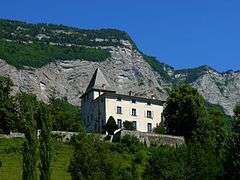
Montbives is a fortified house, built during the 14th century and sitting just below the middle section of the village. It boasts a massive square tower and an impressive kitchen with carved stone pillars.[7]
The château de Serviantin dates back from the 15th century. The name stems from Abel Servien who was born there in 1593 and who later served as a minister for Louis XIII. Its square tower can be seen from chemin de la Grivelière and is a classified historical monument.[8]
The château de Franquières is more recent and dates back from the 17th century. It was built between 1601 and 1610 by the Aymon de Franquières family. During the French revolution, the property belonged to the scientist Laurent-Aymon de Franquières who was elected as the first revolutionary mayor of Grenoble in February 1790 but who knew he was seriously ill and thus resigned in favor of Joseph Marie de Barral. When he died the same year, the property went to Anne-Marie Franquières – most probably his sister – and then to the related McCarthy family in 1809 who renovated it in 1836. In 1852 it moved to Baroness of Vignet, then Charles de Vignet who sold it in 1880 to Félix du Bourg whose family owned it till 1924 when it was sold to the Forest-Colcombet. Finally, it was bought in 1959 by the OVE (Oeuvre des Villages d'Enfants).[7]
The church of Biviers was probably built around 1500. Shortly after the French revolution it was seriously damaged by a violent storm which destroyed its roof, its stained glass windows and even some furniture. It remained unused from 1794 to 1805, but then was significantly modified: it was repaired in 1822, its choir was elevated in 1829, so was its tower in 1845 and its nave in 1873. New bells were acquired in 1883 and placed in a new tower, while the choir was rebuilt in 1885.[7]
Curiously, the water system that feeds Biviers does not tap water from the Chartreuse limestone mountains where the village sits, but from the Belledonne granitic range that towers the valley across the Isère.
The Syndicat Intercommunal des Eaux de la Dhuy (SIED) organizes potable water distribution among 8 villages:
- Bernin
- Biviers
- Corenc
- La Tronche
- Meylan
- Montbonnot-Saint-Martin
- Saint-Ismier
- Saint-Nazaire-les-Eymes
An inverted siphon carries water from Belledonne to reservoirs at the foot of the Chartreuse cliff. Work is under way in the upper part of Biviers (Chatelard) to build a new 6,000 cubic metres (211,888 cu ft) water tank which is planned to be ready by 2010.[9]
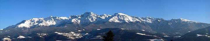 Panorama of Belledonne, seen from Biviers. |
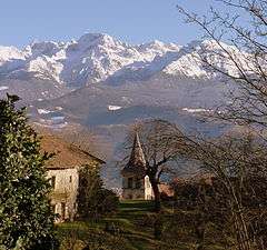
The most impressive monuments close to Biviers are the mountains that surround it such as Dent de Crolles in the Chartreuse range, or Grand Pic de Belledonne in the Belledonne range.
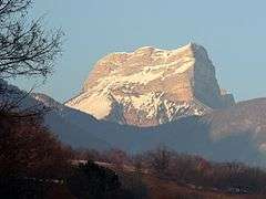 Dent de Crolles, seen from Montbives in Biviers |
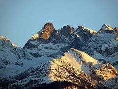 Grand Pic de Belledonne, seen from Biviers |
Economy
In recent years, Biviers posted the highest income tax per active family in Isère[10] with an average salary income per family above €48000, with Saint-Ismier, Corenc, and Bernin as close followers (in that order). In 2007, the net taxable revenue (including salaries) per family went up to €82113[4]
See also
- Urban unit of Grenoble
References
- "Populations légales 2017". INSEE. Retrieved 6 January 2020.
- "Biviers – Risques Naturels" (in French). Pierre Blanc. 31 March 2008. Archived from the original on 14 February 2008. Retrieved 12 April 2008.
- "Communauté de communes du Pays du Grésivaudan" (in French). Archived from the original on 26 August 2010. Retrieved 18 December 2010.
- "Biviers – chiffres clés – Évolution et structure de la population" (PDF) (in French). Archived from the original (Adobe PDF) on 27 July 2011. Retrieved 18 December 2010.
- "Recensement Biviers 2005" (Adobe PDF) (in French). Retrieved 24 January 2009.
- "Statistiques Habitants de Biviers" (in French). Retrieved 24 January 2009.
- "Biviers, histoire, géographie" (in French). Pierre Blanc. Retrieved 25 January 2009.
- "Château Abel Servien". Arnaud KRIESMER (in French). 18 May 2006. Archived from the original on 11 October 2017. Retrieved 2 May 2008.
- "Intercommunalité Biviers". GrésiWEB SI (in French). 18 May 2008. Archived from the original on 11 November 2008. Retrieved 10 January 2009.
- "L'impôt sur le revenu en 2007". Ministère du Budget, des Comptes Publics et de la Fonction Publique, République Française. 31 December 2007. Archived from the original on 16 January 2009. Retrieved 7 February 2009.
External links
| Wikimedia Commons has media related to Biviers. |
All sites are in French, unless otherwise indicated.
- Census data for Biviers on the INSEE site
- Biviers on the French National Geographic Institute – Institut géographique national
- Weather for Biviers
- Tax information for Biviers
- Biviers city site
- History of Biviers
| Authority control |
|
|---|