Moissieu-sur-Dolon
Moissieu-sur-Dolon is a commune in the Isère department in southeastern France.
Moissieu-sur-Dolon | |
|---|---|
Dovecote | |
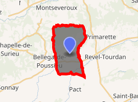
Location of Moissieu-sur-Dolon 
| |
 Moissieu-sur-Dolon  Moissieu-sur-Dolon | |
| Coordinates: 45°23′13″N 4°59′19″E | |
| Country | France |
| Region | Auvergne-Rhône-Alpes |
| Department | Isère |
| Arrondissement | Vienne |
| Canton | Roussillon |
| Intercommunality | Territoire de Beaurepaire |
| Government | |
| • Mayor (2014–2020) | Christian Fanjat |
| Area 1 | 14.38 km2 (5.55 sq mi) |
| Population (2017-01-01)[1] | 707 |
| • Density | 49/km2 (130/sq mi) |
| Time zone | UTC+01:00 (CET) |
| • Summer (DST) | UTC+02:00 (CEST) |
| INSEE/Postal code | 38240 /38270 |
| Elevation | 287–463 m (942–1,519 ft) (avg. 342 m or 1,122 ft) |
| 1 French Land Register data, which excludes lakes, ponds, glaciers > 1 km2 (0.386 sq mi or 247 acres) and river estuaries. | |
Population
| Year | Pop. | ±% |
|---|---|---|
| 1793 | 487 | — |
| 1806 | 552 | +13.3% |
| 1821 | 635 | +15.0% |
| 1831 | 610 | −3.9% |
| 1841 | 605 | −0.8% |
| 1851 | 605 | +0.0% |
| 1861 | 651 | +7.6% |
| 1872 | 599 | −8.0% |
| 1881 | 566 | −5.5% |
| 1891 | 551 | −2.7% |
| 1901 | 560 | +1.6% |
| 1911 | 506 | −9.6% |
| 1921 | 445 | −12.1% |
| 1931 | 452 | +1.6% |
| 1946 | 387 | −14.4% |
| 1954 | 396 | +2.3% |
| 1962 | 387 | −2.3% |
| 1968 | 372 | −3.9% |
| 1975 | 369 | −0.8% |
| 1982 | 407 | +10.3% |
| 1990 | 481 | +18.2% |
| 1999 | 500 | +4.0% |
| 2006 | 675 | +35.0% |
| 2011 | 700 | +3.7% |
gollark: https://github.com/JasonTheKitten/Webicity-DEV
gollark: <@!509348730156220427> develops it, let me find the code.
gollark: Blocked in potatOS I mean.
gollark: It's a browser which is blocked.
gollark: On my long-term todo list is P2P skynet, which would mean you could host your own skynet server and have it peer with existing ones and share messages, to increase reliability.
See also
References
- "Populations légales 2017". INSEE. Retrieved 6 January 2020.
| Wikimedia Commons has media related to Moissieu-sur-Dolon. |
This article is issued from Wikipedia. The text is licensed under Creative Commons - Attribution - Sharealike. Additional terms may apply for the media files.