River Wey
The River Wey is a tributary of the River Thames in south east England.[n 1] Its two branches, one of which rises near Alton in Hampshire and the other in West Sussex to the south of Haslemere,[n 2] join at Tilford in Surrey. Once combined the flow is eastwards then northwards via Godalming and Guildford to meet the Thames at Weybridge. Downstream the river forms the backdrop to Newark Priory and Brooklands. The river is navigable from Godalming to its confluence with the Thames as part of the Wey and Godalming Navigations, built in the 17th century.
| River Wey | |
|---|---|
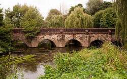 Elstead Bridge, originally built by the monks of Waverley Abbey | |
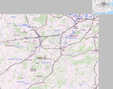 Map of the River Wey | |
| Location | |
| Country | England |
| Counties | West Sussex, Hampshire, Surrey |
| Districts / Boroughs | Chichester (district), East Hampshire (district), Waverley, Guildford, Woking, Elmbridge, Runnymede |
| Towns | Farnham, Haslemere, Godalming, Guildford, Weybridge, Alton, Hampshire |
| Physical characteristics | |
| Source | |
| • location | Alton, East Hampshire, Hampshire |
| 2nd source | |
| • location | Black Down, West Sussex, Chichester, West Sussex |
| Source confluence | |
| • location | Tilford, Waverley, Surrey |
| Mouth | River Thames |
• location | Weybridge, Elmbridge, Surrey |
| Length | 140 km (87 mi) |
| Basin size | 904 km2 (349 sq mi) |
| Discharge | |
| • location | Weybridge |
| • average | 6.76 m3/s (239 cu ft/s) |
| • minimum | 1.30 m3/s (46 cu ft/s)12 August 1990 |
| • maximum | 74.8 m3/s (2,640 cu ft/s)29 December 1979 |
| Discharge | |
| • location | Farnham |
| • average | 0.73 m3/s (26 cu ft/s) |
| Discharge | |
| • location | Tilford |
| • average | 3.25 m3/s (115 cu ft/s) |
| Discharge | |
| • location | Guildford |
| • average | 5.17 m3/s (183 cu ft/s) |
| Basin features | |
| Tributaries | |
| • left | Nadder Stream, Bentworth Stream, Oakhanger Stream, Kingsley Stream, Oxney Stream Hoe Stream, Hollywater, Deadwater, River Slea |
| • right | River Tillingbourne, Cranleigh Waters, River Ock, Caker Stream, East Clandon Stream, Guileshill Brook, Royal Brook, Stratford Brook, Truxford Brook |
The Wey has a total catchment area of 904 square kilometres (350 sq mi), draining parts of Surrey, Hampshire and West Sussex.[1] The river morphology, biodiversity and flow are well studied, with many places to take samples and record data. The main tributary is the Tillingbourne, which rises on the western slopes of Leith Hill and flows westwards to join the Wey to the south of Guildford, between Shalford and Peasmarsh.
The name Wey is of unknown origin and meaning.[2]
Course
Wey North
The Wey North branch rises in Alton in Hampshire and runs eastwards through Upper Froyle and Bentley, turning southeast at Farnham to Tilford.[3] This branch was originally the upper catchment of the River Blackwater; this "early river Wey" captured waters from as far as Tilford. When this branch was blocked at Farnham, the flow spilt over into areas such as Elstead; for a short section past Waverley Abbey the flow has become reversed. The Blackwater remains as a much shorter river to the north of Farnham, with a wind gap (empty valley) between it and the Wey.
Wey South
The Wey South branch commences in two shorter rivers leading from separate sources. One is at Blackdown, south of Haslemere, and runs through Liphook, Bramshott, Passfield, Standford, Lindford and Frensham to Tilford. The other rises at Inval, below Gibbet Hill, Hindhead in the civil parish of Haslemere. This joins the Blackdown-source south branch west of Haslemere. Other smaller tributaries of the south branch are Cooper's Stream and the River Slea.[3]
Combined river
From Tilford the river runs through Elstead, Eashing, Godalming, Peasmarsh/Shalford, Guildford, Send, Old Woking, Pyrford, Byfleet, New Haw and forms the Addlestone/Weybridge border between Hamm Court and Whittet's Ait respectively.[4] From Godalming the river is intertwined with the Wey and Godalming Navigations.[3] The 20 miles (32 km) of towpath of the lower (navigable) section is open to pedestrians. It joins the River Thames between Hamm Court and Whittet's Ait facing a weir stream of Shepperton Lock.
Tributaries
The River Ock joins at Godalming, Cranleigh Waters and the River Tillingbourne at Shalford and the Hoe Stream at Woking.
History
The river has long been used as a source of power for mills, and many are recorded in the Domesday Book. Between the 17th and 19th centuries there over 40 mills on the river and more on its tributaries. At various times they have been used for grinding grain, fulling wool, rolling oats, crushing cattle cake, leather dressing, paper production and gunpowder manufacture. Willey Mill, at Farnham, was still in use in 1953.[5] Headley Mill is still in commercial operation. [6] Guildford Town Mill, though no longer used for milling, still harnesses the power of the river to generate electricity.
During the seventeenth century, the river was made navigable to Guildford and extended in the eighteenth century to Godalming. The Basingstoke Canal and Wey and Arun Junction Canal were later connected to the river. The navigable sections are now owned by the National Trust.
Natural environment
Wey Valley is a term for the narrowing basin of the River Wey before it empties into the River Thames.
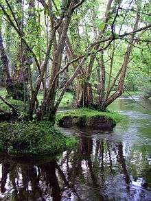
Much of the upper reaches of the river are within the Surrey Hills Area of Outstanding Natural Beauty. The river passes through a variety of habitats including heathland, woodland and watermeadow, resulting in a diversity of wildlife. There are Sites of Special Scientific Interest (SSSI) and Nature Reserves along the river.
The area of the aquifers which drain steeply to the river is great so, as with the Mole, in its natural state much of the flood plains were prone to regular flooding. This has been greatly reduced by flood alleviation, upstream lakes such as Frensham Great Pond and, inadvertently, the Wey Navigation. Urban lowest parts of Godalming, Byfleet and Weybridge saw extensive flooding in the exceptional Winter storms of 2013–14.[7]
Water quality
The Environment Agency measure water quality of the river systems in England. Each is given an overall ecological status, which may be one of five levels: high, good, moderate, poor and bad. There are several components that are used to determine this, including biological status, which looks at the quantity and varieties of invertebrates, angiosperms and fish, and chemical status, which compares the concentrations of various chemicals against known safe concentrations. Chemical status is rated good or fail.[8]
Water quality of the River Wey in 2016:
| Section | Ecological Status | Chemical Status | Overall Status | Length | Catchment | Channel |
|---|---|---|---|---|---|---|
| North Wey at Alton[9] | style="background: #ffff99; text-align: center;" | Moderate | style="background: #7af58a; text-align: center;" | Good | style="background: #ffff99; text-align: center;" | Moderate | 2.802 kilometres (1.741 mi) | 54.231 square kilometres (20.939 sq mi) | Heavily modified |
| North Wey (Alton to Tilford)[10] | style="background: #ffff99; text-align: center;" | Moderate | style="background: #7af58a; text-align: center;" | Good | style="background: #ffff99; text-align: center;" | Moderate | 31.242 kilometres (19.413 mi) | 82.531 square kilometres (31.865 sq mi) | |
| South Wey (Haslemere to Bordon)[11] | style="background: #ffd784; text-align: center;" | Poor | style="background: #7af58a; text-align: center;" | Good | style="background: #ffd784; text-align: center;" | Poor | 17.234 kilometres (10.709 mi) | 40.382 square kilometres (15.592 sq mi) | |
| South Wey (Bordon to River Slea confluence)[12] | style="background: #ffff99; text-align: center;" | Moderate | style="background: #7af58a; text-align: center;" | Good | style="background: #ffff99; text-align: center;" | Moderate | 5.823 kilometres (3.618 mi) | 11.342 square kilometres (4.379 sq mi) | |
| South Wey (River Slea confluence to Tilford)[13] | style="background: #ffff99; text-align: center;" | Moderate | style="background: #7af58a; text-align: center;" | Good | style="background: #ffff99; text-align: center;" | Moderate | 11.633 kilometres (7.228 mi) | 38.999 square kilometres (15.058 sq mi) | |
| Wey (Tilford to Shalford)[14] | style="background: #ffd784; text-align: center;" | Poor | style="background: #7af58a; text-align: center;" | Good | style="background: #ffd784; text-align: center;" | Poor | 23.332 kilometres (14.498 mi) | 63.274 square kilometres (24.430 sq mi) | |
| Wey (Shalford to River Thames confluence at Weybridge)[15] | style="background: #ffff99; text-align: center;" | Moderate | style="background: #7af58a; text-align: center;" | Good | style="background: #ffff99; text-align: center;" | Moderate | 46.346 kilometres (28.798 mi) | 75.772 square kilometres (29.256 sq mi) | Heavily modified |
Surrey rivers
Aside from the River Thames, which does not belong to any one county, the river is one of the two main Surrey rivers, alongside the Mole.
Until its incorporation into London in 1965, next in order of size was the River Wandle. Then follow the River Bourne (Addlestone branch) and the River Bourne, Chertsey which merge. They have sources in Surrey and Berkshire. Surrey's Epsom area is drained by the Hogsmill River, most of which is in outer London.
Further reading
- Inland Waterways Association (South-East Region) The River Wey and Godalming Navigation: Weybridge to Godalming Inland Waterways Association 1976
See also
- Tributaries of the River Thames
- Canals of the United Kingdom
- List of rivers of England
- Perseverance IV, last floating River Wey barge.
- Mills on the River Wey and its tributaries
Notes and references
- Notes
- It is one of two major tributaries in Surrey (the other being the River Mole).
- The western and southern county borders of Surrey approximate the watershed of the lower Chertsey Bourne, Wey and Mole.
- References
- "About the Wey Catchment Abstraction Management Strategy". The Environment Agency website. Archived from the original on 9 February 2008. Retrieved 23 October 2007.
- Mills, A.D. Dictionary of English Place-Names. Oxford: Oxford University Press, 1991. Print. (ISBN 0-19-869156-4)
- The River Wey and Wey Navigations Community Site
- https://www.richmondandtwickenhamtimes.co.uk/news/119186.council-to-take-over-land/
- "All About Watermills & Their Millers". The River Wey & Navigations website. Retrieved 23 October 2007.
- "Headley Mill". Hampshire Mlls Group. Retrieved 2 August 2019.
- Recap: Flood-hit communities prepare for further rainfall Surrey Advertiser Group. 12 February 2014. Retrieved 18 April 2014
- "Glossary (see Biological quality element; Chemical status; and Ecological status)". Catchment Data Explorer. Environment Agency. 17 February 2016.
- "North Wey at Alton". Catchment Data Explorer. Environment Agency.
- "North Wey (Alton to Tilford)". Catchment Data Explorer. Environment Agency.
- "South Wey (Haslemere to Bordon)". Catchment Data Explorer. Environment Agency.
- "South Wey (Bordon to River Slea confluence)". Catchment Data Explorer. Environment Agency.
- "South Wey (River Slea confluence to Tilford)". Catchment Data Explorer. Environment Agency.
- "Wey (Tilford to Shalford)". Catchment Data Explorer. Environment Agency.
- "Wey (Shalford to River Thames confluence at Weybridge)". Catchment Data Explorer. Environment Agency.
External links
| Wikimedia Commons has media related to River Wey, Surrey. |
- The River Wey Trust
- River Wey and Godalming Navigations and Dapdune Wharf
- River Wey Catchment Flood Warnings
| Next confluence upstream | River Thames | Next confluence downstream |
| Wey and Godalming Navigations (south) | River Wey | River Ash (north) |
| Main rivers |
|  |
|---|---|---|
| Canals and Navigations | ||
| Ordinary watercourses | ||
| Lakes, ponds and wetlands | ||
| Coast | ||
Categories: Rivers, Canals | ||
| Authority control |
|
|---|