Fleet Brook
Fleet Brook is a small river in the English county of Hampshire. It is a tributary of the River Hart.
| Fleet Brook | |
|---|---|
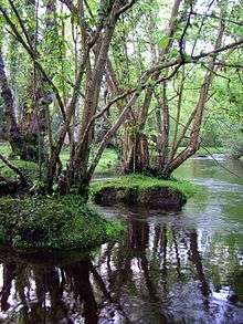
-_Downstream_of_Fleet_Pond_(geograph_5940471).jpg) A long straight section of Fleet Brook below Fleet Pond | |
| Location | |
| Country | England |
| Counties | Hampshire |
| Districts / Boroughs | Hart |
| Physical characteristics | |
| Source | |
| • location | Fleet Pond |
| • coordinates | 51°17′31″N 0°49′46″W |
| Mouth | River Hart |
• location | Hartley Wintney |
• coordinates | 51°18′27″N 0°52′38″W |
Route
Fleet Brook | |||||||||||||||||||||||||||||||||||||||||||||||||||||||||||||||||||||||||||||||||||||||||||||||||||||||||||||||||||||||||||||||||||||||||||||||||||||||||||||||||||||||||||||||||||||||||||||||||||||||||||||||||||||||||||||||||||||||||||||||||||||||||||||||||||
|---|---|---|---|---|---|---|---|---|---|---|---|---|---|---|---|---|---|---|---|---|---|---|---|---|---|---|---|---|---|---|---|---|---|---|---|---|---|---|---|---|---|---|---|---|---|---|---|---|---|---|---|---|---|---|---|---|---|---|---|---|---|---|---|---|---|---|---|---|---|---|---|---|---|---|---|---|---|---|---|---|---|---|---|---|---|---|---|---|---|---|---|---|---|---|---|---|---|---|---|---|---|---|---|---|---|---|---|---|---|---|---|---|---|---|---|---|---|---|---|---|---|---|---|---|---|---|---|---|---|---|---|---|---|---|---|---|---|---|---|---|---|---|---|---|---|---|---|---|---|---|---|---|---|---|---|---|---|---|---|---|---|---|---|---|---|---|---|---|---|---|---|---|---|---|---|---|---|---|---|---|---|---|---|---|---|---|---|---|---|---|---|---|---|---|---|---|---|---|---|---|---|---|---|---|---|---|---|---|---|---|---|---|---|---|---|---|---|---|---|---|---|---|---|---|---|---|---|---|---|---|---|---|---|---|---|---|---|---|---|---|---|---|---|---|---|---|---|---|---|---|---|---|---|---|---|---|---|---|---|
| |||||||||||||||||||||||||||||||||||||||||||||||||||||||||||||||||||||||||||||||||||||||||||||||||||||||||||||||||||||||||||||||||||||||||||||||||||||||||||||||||||||||||||||||||||||||||||||||||||||||||||||||||||||||||||||||||||||||||||||||||||||||||||||||||||
The source of Fleet Brook is somewhere near the town of Fleet, and the river that flows out from Fleet Pond is marked as Fleet Brook by the Ordnance Survey. The streams that flow into Fleet Pond are largely un-named, on modern and historic maps, but are treated as part of Fleet Brook by the Environment Agency, for the purposes of monitoring water quality.
There are four reservoirs near Parkhurst Hill called No.1, No.2, No.3 and No.5, to the south-east of Fleet, with a water treatment works just to the north of Reservoir No.2. For the Environment Agency, they measure water quality from downstream of the water works. The stream flows in a northerly direction, passing under Bourley Road, and is joined by another, which rises from a spring to the west. The stream is briefly called Gelvert Stream as it passes under Aldershot Road and into a depression called Gelvert Bottom. Another stream which begins as a spring and drains joins it before it is crossed by the A323 Norris Hill Road and passes under the Basingstoke Canal. Other drains join it before it dissipates into marsh on the south-eastern edge of Fleet Pond.[1]
A second stream begins on Greendane Copse, a little to the north-west of the reservoirs, and close to Beacon Hill Road. It is culverted under a sports ground, and then reappears on open ground until it reaches Aldershot Road, beyond which it crosses housing estates in Church Crookham and Fleet, largely in culvert, but with short open sections. In Oakley Park, it appears on the surface again, and is joined by another stream, which originates as an overflow on the Basingstoke Canal and passes under the A323 road and Albany Road to reach the northern end of the park. Three more bridges carry the B3010 Kings Road, Southby Drive, and Avondale Road over the watercourse, and it flows into the south-western corner of Fleet Pond.
A third stream begins in the Forest of Eversley near a five-sided enclosure, that was formerly Church Crookham Military sewage treatment works.[2] It was a relatively small works, licensed to discharge a maximum of 1.56 Ml per day in the early 1990s.[3] The stream follows a relatively straight course, passing to the east of a school, under the canal and through housing estates, remaining on the surface until it reaches Brooklyn Gardens, beneath which it is culverted to reach Fleet Pond.[1] The school is Fleet Infants School, designed by Michael Hopkins and Partners in 1984-85 to replace a Victorian building, and built by Hampshire County Council in 1985-86. Because of its innovative design, it is a grade II listed structure, despite its recent construction. When the school was built, the teachers and the architect insisted that the boggy heath land to the south of the site should not be drained to become playing fields, but should be kept for its educational value.[4]
Fleet Pond is part of a nature reserve, and covers around half of the 141-acre (57 ha) of the designated area. The pond is a Site of Special Scientific Interest (SSSI), with varied habitats surrounding it, including heathland, marsh, reedbed and woodland.[5] The pond is first documented in 1324, when there were two ponds which were used as a fishery. In medieval times, "pond" always referred to a man-made structure, whereas "lake" referred to a natural feature, and so it is likely that the ponds were created by raising banks at the northern edge. From 1491, the Prior of Winchester leased the ponds to the occupier of Fleet Farm, in exchange for one hundred fresh fish a year, delivered to Winchester. When the lease was renewed in 1833, it was noted that there was now only one pond. The second pond was probably near Ancells Farm. Shortly afterwards, the London and Southampton Railway bought the pond for £50 as it stood in the way of their line, and built an embankment across the northern end. They appreciated its potential as a tourist destination, and opened Fleet Pond Halt so that day trippers could visit it. Much of the surrounding area became a military training ground in 1854, and as part of that training, soldiers built a 470-yard (430 m) trestle bridge across it in 1885. During the Second World War, the pond was drained, to make the area less visible to enemy aircraft, but it was refilled in 1947, and planted with reeds. The pond became one of the first SSSIs in Hampshire in 1951, and following the passing of the Wildlife and Countryside Act 1981, it was re-registered, although the section to the north of the railway embankment was no longer included. Hart District Council bought the pond and surrounding heathland in 1972, after the army decided it did not need it any more, and since 1976 has worked with the Fleet Pond Society to create a Local nature reserve (LNR). They have installed two bridges to create a circular walk around the pond.[6]
A weir maintains the level of Fleet Pond, and the river exits over it, passes under the A3013 Cove Road, and runs parallel to Minley Road. It then crosses under the road and heads north-west through Broomhurst Wood, under the M3 motorway and is joined by Minley Brook on its right bank.[1] Formerly, this section was less important, and the main river continued northwards from before the Minley Road Bridge. Fleet millpond and Mill were located just to the north of the bridge,[7] but an office block has been built on the site. Beyond Ancells Road, the original course is still in water, passing under Barley Way and the M3 motorway and then weaving between buildings at Brook House, to join Minley Brook. It is now marked as a drain on maps. Minley Brook rises a little further to the east as a series of drains and springs in marshy ground.[1] Brook House is not a listed structure, but predates the town of Fleet by at least 50 years, and possibly considerably more. It appeared as Brook Farm on maps from 1806, when it was already well-established.[8] The remains of a brick-lined moat are located close to the house, and this is a locally listed asset because of its archaeological interest.[9] The stable block and clock tower contain a clock manufactured by John Moore & Son of Clerkenwell in 1830, and repaired by Smith & Sons, also of Clerkenwell, in 1921.[10]
Beyond the junction with Minley Brook, the main river continues westwards, passing Fleet Sewage Treatment Works on its left bank, from which it receives treated effluent. In the early 1990s, it was licensed to discharge a maximum of 23.7 Ml per day into the river.[3] A little further downstream from the works, the river passes under Pale Lane Bridge. After meandering across partially wooded countryside, it is crossed by Home Farm Lane, and briefly enters Elvetham Park, the grounds of Elvetham Hall, where it joins the River Hart on the northern boundary of the Park near Hartley Wintney.[1]
Milling
There is clear evidence for at least one water mill on the Fleet Brook. Isaac Taylor's map of Hampshire, produced in 1759, names Fleet Mill, Fleet Pond and Fleet Farm, and it was marked as a corn mill in 1872.[11] It continued in use until around 1940, and in 1990, English Heritage inspected it to see whether it should become a listed building, but decided that it did not have sufficient merit. The site is now occupied by office buildings, although a small part of the mill has been incorporated into the design.[12]
Water quality
The Environment Agency measure water quality of the river systems in England. Each is given an overall ecological status, which may be one of five levels: high, good, moderate, poor and bad. There are several components that are used to determine this, including biological status, which looks at the quantity and varieties of invertebrates, angiosperms and fish, and chemical status, which compares the concentrations of various chemicals against known safe concentrations. Chemical status is rated good or fail.[13]
The water quality of the Hart system was as follows in 2016.
| Section | Ecological Status | Chemical Status | Overall Status | Length | Catchment | Channel |
|---|---|---|---|---|---|---|
| Fleet Brook[14] | style="background: #ffff99; text-align: center;" | Moderate | style="background: #7af58a; text-align: center;" | Good | style="background: #ffff99; text-align: center;" | Moderate | 10.0 miles (16.1 km) | 12.77 square miles (33.1 km2) | heavily modified |
Reasons for the quality being less than good include discharge from sewage treatment works; runoff from agricultural land; physical barriers such as weirs and impounding of the water which prevent the free migration of fish and other species; runoff from roads; and leaching from landfill sites.
Bibliography
- Killilea, Ailish; O'Fegan, Stephen (June 2017). "Brook House, Fleet, Hampshire" (PDF). Iceni Projects. Archived (PDF) from the original on 11 July 2020.CS1 maint: ref=harv (link)
- NRA (1991). "Fact File - River Blackwater" (PDF). National Rivers Authority. Archived (PDF) from the original on 12 July 2020.CS1 maint: ref=harv (link)
- Society (2016). "History". Fleet Pond Society. Archived from the original on 7 July 2016.CS1 maint: ref=harv (link)
- Vaidya, Ashok, ed. (2013). The Mills and Millers of Hampshire. Volume 3 - North and East. Hampshire Mills Group.CS1 maint: ref=harv (link)
References
- Ordnance Survey, 1:2500 map
- Ordnance Survey, 1:2500 map, 1972-75
- NRA 1991, p. 3.
- Historic England. "Fleet Infant School (1440165)". National Heritage List for England. Retrieved 10 July 2020.
- "Fleet Pond". Hart District Council. Archived from the original on 24 March 2016.
- Society 2016.
- Ordnance Survey, 1:2500 map, 1896
- Killilea & O'Fegan 2017, S3.1-S3.3.
- Killilea & O'Fegan 2017, S1.2.
- Killilea & O'Fegan 2017, S3.5.
- Ordnance Survey, 1:2500 map, 1872
- Vaidya 2013, pp. 80-81.
- "Glossary (see Biological quality element; Chemical status; and Ecological status)". Catchment Data Explorer. Environment Agency. 17 February 2016.
- "Fleet Brook". Catchment Data Explorer. Environment Agency.
External sources
![]()
| Main rivers |
|  |
|---|---|---|
| Canals and Navigations | ||
| Ordinary watercourses | ||
| Lakes, ponds and wetlands | ||
| Coast | ||
Categories: Rivers, Canals | ||