Manor Farm Country Park
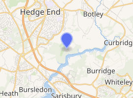
Manor Farm Country Park is a 144.1-hectare (356-acre) Local Nature Reserve which runs along the west bank of the River Hamble between the villages of Botley and Bursledon in Hampshire. It is owned by Hampshire County Council and managed by Hampshire Countryside Service.[1][2] It is part of Solent and Southampton Water Ramsar site[3] and Special Protection Area,[4] and of Solent Maritime Special Area of Conservation.[5] Part of it is in Upper Hamble Estuary and Woods, which is a Site of Special Scientific Interest.[6]
| Manor Farm | |
|---|---|
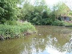 The ancient duckpond at Manor Farm | |
| |
| Type | Local Nature Reserve |
| Location | , Hampshire |
| OS grid | SU 501 114 |
| Area | 144.1 hectares (356 acres) |
| Managed by | Hampshire Countryside Service |
The park first opened in 1979. In 1984, the Manor Farm museum was opened. The museum site was once at the heart of the village of Botley.[7] The ancient duckpond in Manor Farm and the neighbouring St Batholomew's Church are mentioned in the Domesday book.[7] There is evidence of a Roman road running through the site,[8] which would have been the route between the Roman settlements of Clausentum (Bitterne Manor) and Portus Adurni (Portchester).[9]
This park is on the site of the former Royal Navy shore establishment named HMS Cricket.
Once decommissioned in 1946, the buildings that were left behind by the Royal Navy were used to house citizens of Southampton who were displaced by bombing during World War II. The site was then known as "The Cricket Camp", until 1952 when it was no longer required for that purpose.[10]
Most of the wartime buildings have been demolished, but Manor Farm Country Park retains a much smaller "Cricket Camp" which is used by Scouts. It is also home to the Queen Elizabeth II Silver Jubilee Activities Centre.
Manor Farm was the location for the historical documentary TV series Wartime Farm, broadcast by the BBC in 2012.[11]
References
- "Manor Farm". Local Nature Reserves. Natural England. Retrieved 26 May 2020.
- "Map of Manor Farm". Local Nature Reserves. Natural England. Retrieved 26 May 2020.
- "Designated Sites View: Solent and Southampton Water". Ramsar Site. Natural England. Retrieved 23 April 2020.
- "Designated Sites View: Solent and Southampton Water". Special Protection Areas. Natural England. Retrieved 23 April 2020.
- "Designated Sites View: Solent Maritime". Special Areas of Conservation. Natural England. Retrieved 23 April 2020.
- "Designated Sites View: Upper Hamble Estuary and Woods". Sites of Special Scientific Interest. Natural England. Retrieved 28 April 2020.
- Hampshire County Council
- Ordnance Survey
- Blyth, Joyce B., The Changing Face of Hedge End, 1979, ASIN : B0018LRNT6
- Local Heritage Initiative website
- "Wartime Farm official website". Wartimefarm.co.uk. Archived from the original on 19 October 2012. Retrieved 6 November 2018.
External links
- Manor Farm Country Park - official site
- Local Heritage Initiative
- QE2 activity centre (click on "useful info" for more on HMS Cricket)
| Wikimedia Commons has media related to Manor Farm Country Park. |
| Main rivers |
|  |
|---|---|---|
| Canals and Navigations | ||
| Ordinary watercourses | ||
| Lakes, ponds and wetlands | ||
| Coast | ||
Categories: Rivers, Canals | ||