River Ock, Surrey
The River Ock is a tributary of the River Wey in Surrey, England.[1]
| Ock | |
|---|---|
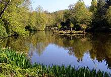
 Millpond on the Ock near Great Enton | |
| Location | |
| Country | England |
| County | Surrey |
| District | Waverley |
| Physical characteristics | |
| Source | |
| • location | Hambledon, Surrey |
| Mouth | River Wey |
• location | Godalming |
| Length | 7.5 km (4.7 mi) |
| Basin size | 26.4 km2 (10.2 sq mi) |
| Basin features | |
| River system | Wey catchment |
| Tributaries | |
| • right | Busbridge stream |
Course
The river rises near Hambledon and then flows north past Witley , followed by Enton, then past Wheelerstreet and Milford on either bank. It is then joined by the Busbridge tributary which drains Busbridge Lakes, passes through Ockford, part of Godalming named for the river, before flowing into the Wey at Godalming. For much of its length, the Portsmouth Main Line follows the watercourse.
Watermills
In Godalming, the Old Mill, originally known as Hatch Mill, made use of the force and speed of the hill-draining brook. Rake Mill at Witley, a former fulling mill, was used by the artist Neville Lytton as a studio, but it, along with the bulk of Lytton's sketches and paintings, was destroyed by a fire in 1902.[2] Other mills on the Ock were a corn mill at Enton and a flour mill at Ockford.
Water quality
The Environment Agency measure water quality of the river systems in England. Each is given an overall ecological status, which may be one of five levels: high, good, moderate, poor and bad. There are several components that are used to determine this, including biological status, which looks at the quantity and varieties of invertebrates, angiosperms and fish, and chemical status, which compares the concentrations of various chemicals against known safe concentrations. Chemical status is rated good or fail.[3]
The water quality of the Ock was as follows in 2016:
| Section | Ecological Status | Chemical Status | Overall Status | Length | Catchment | Channel |
|---|---|---|---|---|---|---|
| River Ock[4] | style="background: #dd9393; text-align: center;" | Bad | style="background: #7af58a; text-align: center;" | Good | style="background: #dd9393; text-align: center;" | Bad | 7.51 km (4.67 mi) | 26.394 km2 (10.191 sq mi) | |
References
- "Ock". Catchment Data Explorer. Environment Agency. Retrieved 30 January 2019.
- Apin, John (ed.). The Letters of Philip Webb, Volume 3. ISBN 978-1-315-64256-7.
- "Glossary (see Biological quality element; Chemical status; and Ecological status)". Catchment Data Explorer. Environment Agency. 17 February 2016.
- "River Ock". Catchment Data Explorer. Environment Agency.