Richecourt
Richecourt is a commune in the Meuse department in Grand Est in north-eastern France.
Richecourt | |
|---|---|
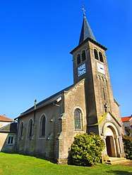 The church in Richecourt | |
 Coat of arms | |
Location of Richecourt 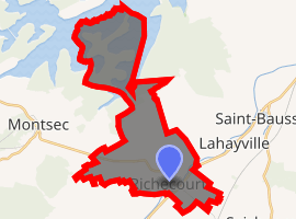
| |
 Richecourt  Richecourt | |
| Coordinates: 48°52′50″N 5°45′43″E | |
| Country | France |
| Region | Grand Est |
| Department | Meuse |
| Arrondissement | Commercy |
| Canton | Saint-Mihiel |
| Intercommunality | Communauté de communes de la Petite Woëvre |
| Government | |
| • Mayor (2008–2014) | Daniel Rouyer |
| Area 1 | 6.23 km2 (2.41 sq mi) |
| Population (2017-01-01)[1] | 59 |
| • Density | 9.5/km2 (25/sq mi) |
| Time zone | UTC+01:00 (CET) |
| • Summer (DST) | UTC+02:00 (CEST) |
| INSEE/Postal code | 55431 /55300 |
| Elevation | 223–243 m (732–797 ft) (avg. 239 m or 784 ft) |
| 1 French Land Register data, which excludes lakes, ponds, glaciers > 1 km2 (0.386 sq mi or 247 acres) and river estuaries. | |
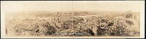
World War I damage at Richecourt
Geography
The village lies on the left bank of the Rupt de Mad, which flows northeastward through the south-eastern part of the commune.
gollark: !typerace 10
gollark: !typerace 50
gollark: morningward
gollark: morningward?
gollark: Hey, you should make it log historical typing speeds in each race in a SQLite database!
See also
- Communes of the Meuse department
- Parc naturel régional de Lorraine
References
- "Populations légales 2017". INSEE. Retrieved 6 January 2020.
| Wikimedia Commons has media related to Richecourt (Meuse). |
| Authority control |
|
|---|
This article is issued from Wikipedia. The text is licensed under Creative Commons - Attribution - Sharealike. Additional terms may apply for the media files.