Rambucourt
Rambucourt is a commune in the Meuse department in Grand Est in north-eastern France.
Rambucourt | |
|---|---|
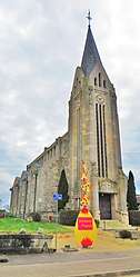 The church in Rambucourt | |
 Coat of arms | |
Location of Rambucourt 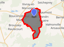
| |
 Rambucourt  Rambucourt | |
| Coordinates: 48°50′41″N 5°45′32″E | |
| Country | France |
| Region | Grand Est |
| Department | Meuse |
| Arrondissement | Commercy |
| Canton | Saint-Mihiel |
| Intercommunality | Communauté de communes de la Petite Woëvre |
| Government | |
| • Mayor (2008–2014) | Bernard Carle |
| Area 1 | 14.86 km2 (5.74 sq mi) |
| Population (2017-01-01)[1] | 189 |
| • Density | 13/km2 (33/sq mi) |
| Time zone | UTC+01:00 (CET) |
| • Summer (DST) | UTC+02:00 (CEST) |
| INSEE/Postal code | 55412 /55300 |
| Elevation | 224–274 m (735–899 ft) (avg. 257 m or 843 ft) |
| 1 French Land Register data, which excludes lakes, ponds, glaciers > 1 km2 (0.386 sq mi or 247 acres) and river estuaries. | |
Geography
The Rupt de Mad forms part of the commune's north-western border.
gollark: Nonsense, venting about programming is 1293718924% esolangs.
gollark: And maybe try and explain technical debt?
gollark: Sinthorion, YOU should achieve ABR achievements.
gollark: Would you say it's worse or better than my Discord bot?
gollark: βee.
See also
- Communes of the Meuse department
- Parc naturel régional de Lorraine
References
- "Populations légales 2017". INSEE. Retrieved 6 January 2020.
| Wikimedia Commons has media related to Rambucourt. |
| Authority control |
|
|---|
This article is issued from Wikipedia. The text is licensed under Creative Commons - Attribution - Sharealike. Additional terms may apply for the media files.