Poruba, Prievidza District
Poruba (Hungarian: Mohos) is a village in central Slovakia.
Poruba | |
|---|---|
Village | |
 | |
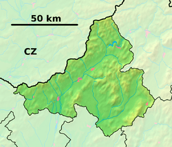 Poruba Location of Poruba in the Trenčín Region  Poruba Location of Poruba in Slovakia | |
| Coordinates: 48°49′N 18°35′E | |
| Country | |
| Region | Trenčín |
| District | Prievidza |
| First mentioned | 1339 |
| Area | |
| • Total | 15 km2 (6 sq mi) |
| Elevation | 400 m (1,300 ft) |
| Population (2004-12-31) | |
| • Total | 1,287 |
| • Density | 86/km2 (220/sq mi) |
| Postal code | 972 11 |
| Area code(s) | +421-46 |
| Car plate | PD |
| Website | www.poruba.sk |
History
In historical records the village was first mentioned in 1339.
Geography
The municipality lies at an altitude of 400 metres and covers an area of 15.145 km². It has a population of about 1,287 people. Poruba belongs to the Prievidza District of the Trenčín Region.
gollark: ++remind 0.003My BEE you.
gollark: Just use kiloyears.
gollark: I did implement decaseconds! Good job me.
gollark: ++remind 40m-10das bee you
gollark: Make Macron.
External links

- Official website

This article is issued from Wikipedia. The text is licensed under Creative Commons - Attribution - Sharealike. Additional terms may apply for the media files.