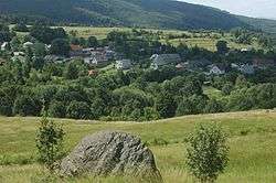
Podhradie, Prievidza District
Podhradie (Hungarian: Keselőkő) is a village and municipality in Prievidza District in the Trenčín Region of western Slovakia.
Podhradie | |
|---|---|
Municipality | |
 | |
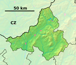 Podhradie Location of Podhradie in the Trenčín Region  Podhradie Location of Podhradie in Slovakia | |
| Coordinates: 48°41′00″N 18°38′00″E | |
| Country | |
| Region | Trenčín |
| District | Prievidza |
| First mentioned | 1352 |
| Area | |
| • Total | 12.757 km2 (4.926 sq mi) |
| Elevation | 550 m (1,800 ft) |
| Population | |
| • Total | 331 |
| • Density | 26/km2 (67/sq mi) |
| Time zone | UTC+1 (CET) |
| • Summer (DST) | UTC+2 (CEST) |
| Postal code | 972 42 (pošta Lehota pod Vtáčnikom) |
| Area code(s) | 421-46 |
| Car plate | PD |
| Website | www.podhradie.eu |
History
In historical records the village was first mentioned in 1352.
Geography
The municipality lies at an altitude of 550 metres and covers an area of 12.757 km². It has a population of about 331 people.
gollark: Oh, unless you use `Box` explicitly.
gollark: Rust monomorphises *all* generics and this causes no* problems.
gollark: M O N O M O R P H I S E ™
gollark: It's some kind of weird type switch.
gollark: C has "generics" but they are not what anyone actually means.
External links

- Official website

- http://www.statistics.sk/mosmis/eng/run.html
This article is issued from Wikipedia. The text is licensed under Creative Commons - Attribution - Sharealike. Additional terms may apply for the media files.