Lehota pod Vtáčnikom
Lehota pod Vtáčnikom (Hungarian: Papszabadi) is a village and municipality in Prievidza District in the Trenčín Region of western Slovakia.
Lehota pod Vtáčnikom | |
|---|---|
Village | |
 Lehota pod Vtáčnikom | |
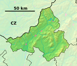 Lehota pod Vtáčnikom Location of Lehota pod Vtáčnikom in the Trenčín Region  Lehota pod Vtáčnikom Location of Lehota pod Vtáčnikom in Slovakia | |
| Coordinates: 48°41′43″N 18°36′17″E | |
| Country | |
| Region | Trenčín |
| District | Prievidza |
| First mentioned | 1362 |
| Area | |
| • Total | 27.972 km2 (10.800 sq mi) |
| Elevation | 348 m (1,142 ft) |
| Population (31 December 2005) | |
| • Total | 3,795 |
| • Density | 140/km2 (350/sq mi) |
| Time zone | UTC+1 (CET) |
| • Summer (DST) | UTC+2 (CEST) |
| Postal code | 972 42 |
| Area code(s) | 421-46 |
| Car plate | PD |
| Website | www.lehotapodvtacnikom.sk |
History
In historical records the village was first mentioned in 1362. In Lehota pod Vtáčnikom the Football club OFK Baník Lehota pod Vtáčnikom.
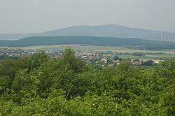
Geography
The municipality lies at an altitude of 397 metres and covers an area of 27.972 km². It has a population of about 3795 people.
gollark: The incentives are not in favour of this.
gollark: People would complain a lot, and do not burn cleanly.
gollark: That isn't actually very good.
gollark: What?
gollark: I mostly just assume that things will go horribly unless someone comes up with a convenient workaround requiring no social change, such as geoengineering or something.
External links

- Official website

- https://web.archive.org/web/20080111223415/http://www.statistics.sk/mosmis/eng/run.html
| Authority control |
|
|---|
This article is issued from Wikipedia. The text is licensed under Creative Commons - Attribution - Sharealike. Additional terms may apply for the media files.