Dolné Vestenice
Dolné Vestenice (Hungarian: Alsóvesztény) is a village and municipality in Prievidza District in the Trenčín Region of western Slovakia.
Dolné Vestenice | |
|---|---|
Village | |
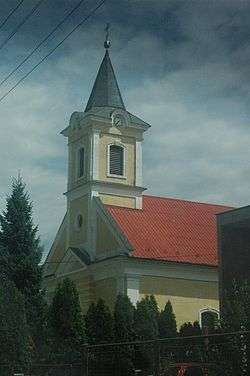 Church of the Immaculate Conception | |
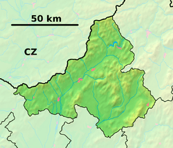 Dolné Vestenice Location of Dolné Vestenice in the Trenčín Region  Dolné Vestenice Location of Dolné Vestenice in Slovakia | |
| Coordinates: 48°42′N 18°24′E | |
| Country | |
| Region | Trenčín |
| District | Prievidza |
| First mentioned | 1349 |
| Area | |
| • Total | 13.836 km2 (5.342 sq mi) |
| Elevation | 243 m (797 ft) |
| Population (2004-12-31) | |
| • Total | 2,686 |
| • Density | 190/km2 (500/sq mi) |
| Postal code | 972 23 |
| Area code(s) | +421-46 |
| Car plate | PD |
| Website | www.dolnevestenice.sk |
History
In historical records the village was first mentioned in 1349.
Geography
The municipality lies at an altitude of 228 metres and covers an area of 13.836 km². It has a population of about 2,686 people.
Genealogical resources
The records for genealogical research are available at the state archive "Statny Archiv in Nitra, Slovakia"
- Roman Catholic church records (births/marriages/deaths): 1702-1935 (parish B)
gollark: https://github.com/reddit-archive/reddit
gollark: I mean:- not telling anyone much about development- private testing for a week- source code is now closed- NDAs for some reason?- not really being very specific about feature changes even *after* they happenis all pretty secretive to me.
gollark: Reddit used to be open source, you know.
gollark: Yep!
gollark: Well, it is an example of secretiveness.
External links
![]()
This article is issued from Wikipedia. The text is licensed under Creative Commons - Attribution - Sharealike. Additional terms may apply for the media files.