Nitrianske Rudno
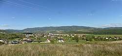
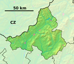
Nitrianske Rudno (Slovak pronunciation: [ˈɲitɾɪ̯anskɛ ˈɾudnɔ]; Hungarian: Divékrudnó) is a village and municipality in Prievidza District in the Trenčín Region of western Slovakia.
Nitrianske Rudno | |
|---|---|
Municipality | |
 | |
 Nitrianske Rudno Location of Nitrianske Rudno in the Trenčín Region  Nitrianske Rudno Location of Nitrianske Rudno in Slovakia | |
| Coordinates: 48°48′N 18°29′E | |
| Country | |
| Region | Trenčín |
| District | Prievidza |
| First mentioned | 1275 |
| Area | |
| • Total | 14.501 km2 (5.599 sq mi) |
| Elevation | 318 m (1,043 ft) |
| Population | |
| • Total | 1,960 |
| • Density | 140/km2 (350/sq mi) |
| Time zone | UTC+1 (CET) |
| • Summer (DST) | UTC+2 (CEST) |
| Postal code | 972 26 |
| Area code(s) | 421-46 |
| Car plate | PD |
| Website | www.nitrianskerudno.sk |
History
In historical records the village was first mentioned in 1275.
Geography
The municipality lies at an altitude of 318 metres and covers an area of 14.501 km². It has a population of about 1960 people.
gollark: Where is it?
gollark: Cool.
gollark: I think there's a rule about defacing the environment, but that means it's fine to mine out everything under y=40 or so because nobody looks there.
gollark: It might be annoying to route around claims. But I think you could do it if they also had a block scanner (or a few did) or pickaxes.
gollark: With some Wojbie2-style setup to attain fire aspect books it would probably be possible to get more lasers than that, and the bot could also supervise the turtles so no human input is needed.
External links

- Official website

- http://www.statistics.sk/mosmis/eng/run.html
This article is issued from Wikipedia. The text is licensed under Creative Commons - Attribution - Sharealike. Additional terms may apply for the media files.