Poços de Caldas
Poços de Caldas is a municipality in southwestern Minas Gerais state, Brazil, in the microregion of the same name. Its estimated population in 2018 was 166,111 inhabitants.[2] The city has hot springs.
Poços de Caldas, Minas Gerais, Brazil | |
|---|---|
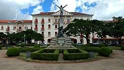
 Poços de Caldas in 2009 | |
.png) Flag Seal | |
| Nickname(s): Cidade das Rosas | |
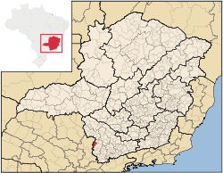
 Location in Minas Gerais | |
 Poços de Caldas, Minas Gerais, Brazil Location in Minas Gerais | |
| Coordinates: 21°47′16″S 46°33′39″W | |
| Country | Brazil |
| Region | Southeast |
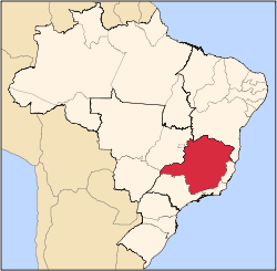
| State | Minas Gerais |
| Founded | November 6, 1872 |
| Government | |
| • Mayor | Sérgio Azevedo |
| Area | |
| • City | 546.958 km2 (211.182 sq mi) |
| • Urban | 85 km2 (33 sq mi) |
| Elevation | 1,196 m (3,924 ft) |
| Population (2018 est.[2]) | |
| • City | 166,111 |
| • Density | 300/km2 (790/sq mi) |
| Time zone | UTC-3 (UTC-3) |
| • Summer (DST) | UTC-2 (UTC-2) |
| Website | pocosdecaldas.mg.gov.br |
History
Poços was founded in 1872. The region had been inhabited by the Cataguases Indians, who were expelled from their lands by the Bandeiras Unidas Paulistas during their quest for gold. The place was first called Freguesia de Nossa Senhora da Saúde das Águas de Caldas ("Parish of Our Lady of Health of Caldas Waters"). In 1874 it became a district, then in 1875 it was elevated to the category of city. It became famous after the discovery of the hot springs, and many important people began to visit the spa in search of cures provided by the water.
The name comes from Caldas da Rainha, a spa town in central Portugal.
Geography
It lies on the boundary of the state of São Paulo at 1186 meters elevation and is the main socio-economic nucleus of its region, having an area of 547 km² (85 km² urban and 459 km² rural) in the municipality.
The physical area is made up for the most part of a high plateau formed by mountains, fields and valleys with an area of approximately 750 km². The average elevation is 1200 m (3937 ft), with Cristo Redentor, the highest point, at 1686 m (5531 ft). The topography is highly suggestive of a volcanic crater and, given that the region's rocks are indeed igneous and there are hot springs, this gave rise to a common misconception that Poços de Caldas would be located inside the crater of a large extinct volcano. In reality, Poços de Caldas is inside a caldera that was formed by the collapse of a central portion of terrain amid elevated areas, and while the latter have volcanic origin, the process that formed the supposed "crater" had nothing to do with volcanic activity.[3]
Poços de Caldas occupies a highly strategic geographical location, due to its proximity to São Paulo (243 km), Belo Horizonte (460 km) and Rio de Janeiro (470 km), whose connections are made with good highways, and due to its integration into the routes of the hydro-mineral spas of Serra Negra, Águas de Lindóia, Socorro, Monte Alegre do Sul, Águas da Prata, Caldas (Pocinhos do Rio Verde), Cambuquira, Lambari, Caxambu and São Lourenço. Poços de Caldas is also close to the most developed regions of the interior of the state of São Paulo, such as Ribeirão Preto (240 km), Campinas (160 km) and São José dos Campos (315 km).
Climate
The climate is characterized by dry winters and mild summers. The winter is from April to September and has an average temperature of 15 °C and rainfall of 315 mm. The summer is from October to March and has an average temperature of 21 °C with rainfall of 1,430 mm. The annual rainfall is 1,745 mm. The average annual temperature is 17 °C with minima of -6 °C and maxima of 31.7 °C.
Economy
Known principally for its thermal baths, there are several resorts in the city. Due to its wealth in hydro-mineral resources, Poços de Caldas is also known for the quality of the soap that it produces. There are four factories in the city: Raízes, Antares, Sarandi and Terra Brasil. Poços is famous for its glass, which is known internationally. The founders of the factories were descendants of the artistic glassmakers who lived on the Island of Murano, near Venice, in Italy. In the city there are four glass factories: Ca'D'oro, São Marcos, Veneza and Bonora.
The local soils are rich in minerals that yield thorium and zirconium. One rare zirconium ore, caldasite, was named for the area. The city has Brazil's first uranium-ore concentration plant, for use in the Angra Nuclear Power Plant in Angra dos Reis.
Poços is also the home of one of the largest bauxite mines in the world, owned by Alcoa. Bauxite is an ore that contains at least 45% alumina, which is extracted to make aluminum. The smelting operations at Poços de Caldas have an annual capacity of 90,000 tons/year of primary aluminum. The facility is the largest aluminum-powder production facility in Latin America, and the second largest in the world. The plant has a capacity of 14,000 tonnes/year of aluminum powder and meets the market demand for ferroalloys, refractories, pigments, metallurgy, chemicals, explosives and solid fuel for rockets. The facility began production of hydrated aluminas and hard-burned calcined aluminas in 1985.
The city gets most of its electricity from hydroelectric power plants, built and administrated with local resources (dimethyl ether), leading to independence from the state's power system.
Tourism
The city is very well taken care of, with several green areas, among parks, squares, gardens and São Domingos mountain, which has trails for walking. The sulphurous water is the main attraction and can be consumed in several fountains and at the Thermas Antônio Carlos. There is an aerial tram to get to the Statue of Christ the Redeemer (1,686 m). At the top of the mountain there is a great view of the nearby mountains. The city also offers options such as a Japanese tea garden, a theme park, museums, theaters, and other cultural events, including the yearly Music in the Mountains Festival (Festival Musica nas Montanhas).
The city is served by Emb. Walther Moreira Salles Airport.
 Antônio Carlos Spa
 Cable car and Palace Casino
.jpg) Classical Bandstand
Classical Bandstand.jpg) Luminous fountain
Luminous fountain The region of the volcanic caldera inactive 90 million years ago
Sister Cities
- Caldas da Rainha, Portugal
- Mount Vernon, New York, United States
References
- "Brazilian Institute of Geography and Statistics" (in Portuguese). 2017. Retrieved 27 March 2019.
2018 Area Total
- "Brazilian Institute of Geography and Statistics" (PDF) (in Portuguese). 2018. Retrieved 6 March 2019.
2018 Estimates of Population
- "A Verdadeira História sobre o Vulcão (The True Story about the Volcano)" (in Portuguese). Retrieved 2010-12-23.
