Setubinha
Setubinha is a municipality in the northeast of the Brazilian state of Minas Gerais. As of 2007 the population was 10,834 in a total area of 536 km². The elevation is 729 metres. It is part of the IBGE statistical microregion of Teófilo Otoni
Setubinha | |
|---|---|
 Flag  Seal | |
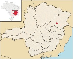 Location in Minas Gerais | |
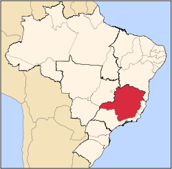
 Setubinha Location in Brazil | |
| Coordinates: 17°36′00″S 42°09′32″W | |
| Country | |
| Region | Southeast |
| State | |
| Mesoregion | Mucuri Valley |
| Microregion | Teófilo Otoni |
| Incorporated (municipality) | December 22, 1995 |
| Government | |
| • Mayor | Warlem Antônio José Barbosa |
| Area | |
| • Total | 534.655 km2 (206.431 sq mi) |
| Elevation | 750 m (2,460 ft) |
| Population (2006) | |
| • Total | 11,952 |
| [1] | |
| Time zone | UTC-3 (BRT) |
| • Summer (DST) | UTC-2 (BRST) |
| HDI (2010) | 0.542 |
| Website | setubinha.mg.gov.br |
The economy is based on cattle raising and agriculture, with the main crops being coffee, bananas, sugarcane, and corn. As of 2005 there were no hospitals and 3 public health clinics. In 2006 there were 14 primary schools and 2 middle schools.
References
- "Setubinha". Instituto Brasileiro de Geografia e Estatística. Retrieved 2017-01-19.
External links
Capital: Belo Horizonte | |||||||||||||||||||||||||
|  | ||||||||||||||||||||||||
|
| |||||||||||||||||||||||||
| |||||||||||||||||||||||||
| |||||||||||||||||||||||||
| |||||||||||||||||||||||||
| |||||||||||||||||||||||||
| |||||||||||||||||||||||||
| |||||||||||||||||||||||||
| |||||||||||||||||||||||||
| |||||||||||||||||||||||||
| |||||||||||||||||||||||||
This article is issued from Wikipedia. The text is licensed under Creative Commons - Attribution - Sharealike. Additional terms may apply for the media files.