Otego Township, Fayette County, Illinois
Otego Township is one of twenty townships in Fayette County, Illinois, USA. As of the 2010 census, its population was 1,511 and it contained 666 housing units.[2] Its name changed from Cumberland township on September 24, 1860. Overcup Church is located in this township.
Otego Township | |
|---|---|
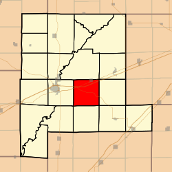 Location in Fayette County | |
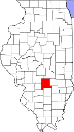 Fayette County's location in Illinois | |
| Coordinates: 38°57′09″N 88°58′45″W | |
| Country | United States |
| State | Illinois |
| County | Fayette |
| Established | November 9, 1859 |
| Area | |
| • Total | 35.42 sq mi (91.7 km2) |
| • Land | 35.34 sq mi (91.5 km2) |
| • Water | 0.08 sq mi (0.2 km2) 0.23% |
| Elevation | 561 ft (171 m) |
| Population (2010) | |
| • Estimate (2016)[1] | 1,470 |
| • Density | 42.8/sq mi (16.5/km2) |
| Time zone | UTC-6 (CST) |
| • Summer (DST) | UTC-5 (CDT) |
| ZIP codes | 62418, 62471, 62838, 62857, 62880 |
| FIPS code | 17-051-56913 |
Geography
According to the 2010 census, the township has a total area of 35.42 square miles (91.7 km2), of which 35.34 square miles (91.5 km2) (or 99.77%) is land and 0.08 square miles (0.21 km2) (or 0.23%) is water.[2]
Cities, towns, villages
- Brownstown (south three-quarters)
Unincorporated towns
(This list is based on USGS data and may include former settlements.)
Cemeteries
The township contains these six cemeteries: Arm Prairie, Griffith, Mitchell Family, Morton, Pilcher and Winslow Pilcher.
Major highways


School districts
- Brownstown Community Unit School District 201
- Vandalia Community Unit School District 203
Political districts
- Illinois' 19th congressional district
- State House District 102
- State Senate District 51
gollark: SPUDNET's long polling thing simply ignores that.
gollark: Are routers compatible with Gaming Ethernet generally?
gollark: Oh no. I might need to buy a Gaming Ethernet switch!
gollark: What? It isn't very practical. You immediately suffocate.
gollark: You can sort of work around the world border with nether portals.
References
- "Otego Township, Fayette County, Illinois". Geographic Names Information System. United States Geological Survey. Retrieved 2010-01-16.
- United States Census Bureau 2007 TIGER/Line Shapefiles
- United States National Atlas
- "Population and Housing Unit Estimates". Retrieved June 9, 2017.
- "Population, Housing Units, Area, and Density: 2010 - County -- County Subdivision and Place -- 2010 Census Summary File 1". United States Census. Archived from the original on 2020-02-12. Retrieved 2013-05-28.
- "Census of Population and Housing". Census.gov. Retrieved June 4, 2016.
External links
Places adjacent to Otego Township, Fayette County, Illinois | |
|---|---|
Municipalities and communities of Fayette County, Illinois, United States | ||
|---|---|---|
| Cities | Map of Illinois highlighting Fayette County | |
| Villages | ||
| Townships | ||
| Unincorporated communities | ||
This article is issued from Wikipedia. The text is licensed under Creative Commons - Attribution - Sharealike. Additional terms may apply for the media files.