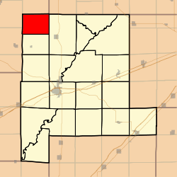
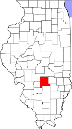
North Hurricane Township, Fayette County, Illinois
North Hurricane Township is one of twenty townships in Fayette County, Illinois, USA. As of the 2010 census, its population was 257 and it contained 106 housing units.[1] This township, along with South Hurricane Township, formed when Hurricane Township split sometime after 1921.
North Hurricane Township | |
|---|---|
 Location in Fayette County | |
 Fayette County's location in Illinois | |
| Coordinates: 39°11′05″N 89°11′59″W | |
| Country | United States |
| State | Illinois |
| County | Fayette |
| Area | |
| • Total | 27.09 sq mi (70.2 km2) |
| • Land | 27.06 sq mi (70.1 km2) |
| • Water | 0.03 sq mi (0.08 km2) 0.11% |
| Elevation | 643 ft (196 m) |
| Population (2010) | |
| • Total | 257 |
| • Density | 9.5/sq mi (3.7/km2) |
| Time zone | UTC-6 (CST) |
| • Summer (DST) | UTC-5 (CDT) |
| ZIP codes | 62011, 62075, 62080 |
| GNIS feature ID | 0429159 |
Geography
According to the 2010 census, the township has a total area of 27.09 square miles (70.2 km2), of which 27.06 square miles (70.1 km2) (or 99.89%) is land and 0.03 square miles (0.078 km2) (or 0.11%) is water.[1]
Cemeteries
The township contains these six cemeteries: Casey, Craig, Halford, Little Hickory, Mount Carmel and Stokes.
Landmarks
- Ramsey Lake State Recreation Area (west quarter)
School districts
- Nokomis Community Unit School District 22
- Ramsey Community Unit School District 204
Political districts
- Illinois' 17th congressional district
- State House District 98
- State Senate District 49
gollark: After all, SOMEONE HERE uses GOLANG.
gollark: Clearly we must add this.
gollark: ...
gollark: https://golang.org/lib/godoc/images/go-logo-blue.svg
gollark: oops.
References
- "North Hurricane Township, Fayette County, Illinois". Geographic Names Information System. United States Geological Survey. Retrieved 2010-01-16.
- United States Census Bureau 2007 TIGER/Line Shapefiles
- United States National Atlas
- "Population, Housing Units, Area, and Density: 2010 - County -- County Subdivision and Place -- 2010 Census Summary File 1". United States Census. Archived from the original on 2020-02-12. Retrieved 2013-05-28.
External links
This article is issued from Wikipedia. The text is licensed under Creative Commons - Attribution - Sharealike. Additional terms may apply for the media files.