National Register of Historic Places listings in Woodruff County, Arkansas
This is a list of the National Register of Historic Places listings in Woodruff County, Arkansas.
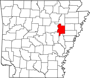
Location of Woodruff County in Arkansas
This is intended to be a complete list of the properties and districts on the National Register of Historic Places in Woodruff County, Arkansas, United States. The locations of National Register properties and districts for which the latitude and longitude coordinates are included below, may be seen in a map.[1]
There are 17 properties and districts listed on the National Register in the county.
- This National Park Service list is complete through NPS recent listings posted August 14, 2020.[2]
Current listings
| [3] | Name on the Register[4] | Image | Date listed[5] | Location | City or town | Description |
|---|---|---|---|---|---|---|
| 1 | Augusta Commercial Historic District | 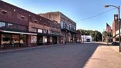 Augusta Commercial Historic District |
August 27, 2008 (#08000817) |
Roughly bounded by 1st, Locust, Main, 2nd, and Pearl Sts. 35°17′01″N 91°22′01″W |
Augusta | |
| 2 | Augusta Electrical Generating Plant | 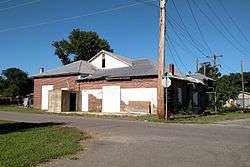 Augusta Electrical Generating Plant |
September 23, 2010 (#10000788) |
Southwest corner of 5th and Locust Sts. 35°17′00″N 91°21′47″W |
Augusta | |
| 3 | Augusta Memorial Park Historic Section | 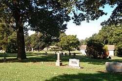 Augusta Memorial Park Historic Section |
June 5, 2003 (#03000507) |
Bounded by Iris, Rose, and Hough Drives and Highway 33B 35°17′22″N 91°21′44″W |
Augusta | |
| 4 | Augusta Presbyterian Church | 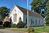 Augusta Presbyterian Church |
October 16, 1986 (#86002873) |
3rd and Walnut Sts. 35°17′11″N 91°21′57″W |
Augusta | |
| 5 | Cotton Plant Commercial Historic District | 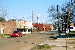 Cotton Plant Commercial Historic District |
September 25, 2008 (#08000946) |
Main St. roughly between Pine and Ash Sts. 35°00′17″N 91°15′09″W |
Cotton Plant | |
| 6 | Cotton Plant Water Tower | 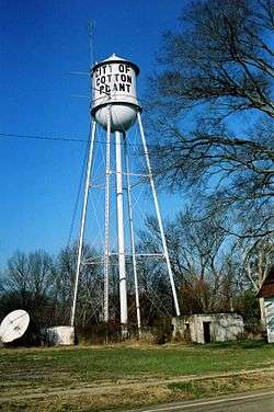 Cotton Plant Water Tower |
June 4, 2008 (#08000490) |
Junction of N. Main and N. Vine Sts. 35°00′16″N 91°14′58″W |
Cotton Plant | |
| 7 | Ferguson House | 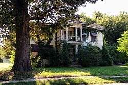 Ferguson House |
December 6, 1975 (#75000419) |
416 N. 3rd St. 35°17′09″N 91°21′53″W |
Augusta | |
| 8 | Fitzhugh Snapp Company | 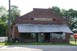 Fitzhugh Snapp Company |
January 18, 2005 (#04001069) |
Junction of County Roads 140 and 165 35°21′35″N 91°19′23″W |
Fitzhugh | |
| 9 | George Washington Carver High School Home Economics Building | 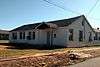 George Washington Carver High School Home Economics Building |
January 15, 2004 (#03001381) |
900 Pearl St. 35°17′10″N 91°21′26″W |
Augusta | |
| 10 | Gregory House | 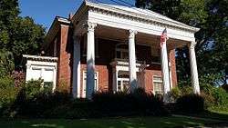 Gregory House |
October 17, 2012 (#12000858) |
300 S. 2nd St. 35°16′54″N 91°22′00″W |
Augusta | |
| 11 | Jess Norman Post 166 American Legion Hut | 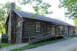 Jess Norman Post 166 American Legion Hut |
October 14, 2001 (#01001100) |
222 S. 1st St. 35°16′54″N 91°22′04″W |
Augusta | |
| 12 | Mathis-Hyde House | 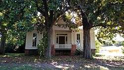 Mathis-Hyde House |
May 25, 2011 (#11000304) |
400 N. 2nd St. 35°17′11″N 91°22′00″W |
Augusta | |
| 13 | McCrory Commercial Historic District | 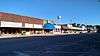 McCrory Commercial Historic District |
September 23, 2010 (#10000781) |
Roughly Edmonds Ave. between Railroad & Third Sts. 35°15′26″N 91°12′00″W |
McCrory | |
| 14 | McCrory Waterworks | 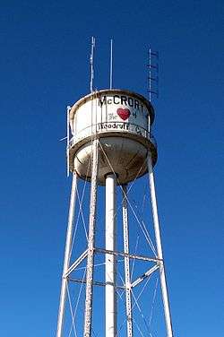 McCrory Waterworks |
September 20, 2007 (#07000968) |
Junction of N. Fakes and W. 3rd 35°15′28″N 91°12′02″W |
McCrory | |
| 15 | Dr. John William Morris Clinic | 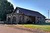 Dr. John William Morris Clinic |
October 5, 2009 (#09000801) |
118 W. Main St. 35°15′23″N 91°11′59″W |
McCrory | |
| 16 | Revel General Store | September 27, 2003 (#03000952) |
Junction of Highway 260 and County Road 17 35°13′48″N 91°16′54″W |
Revel | ||
| 17 | Woodruff County Courthouse | 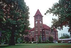 Woodruff County Courthouse |
December 22, 1982 (#82000959) |
500 N. 3rd St. 35°17′15″N 91°21′52″W |
Augusta |
Former listings
| [3] | Name on the Register | Image | Date listed | Date removed | Location | City or town | Summary |
|---|---|---|---|---|---|---|---|
| 1 | Augusta Bridge | 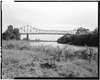 Augusta Bridge |
April 9, 1990 (#90000505) | September 14, 2002 | U.S. Route 64, over the White River |
Augusta |
gollark: The main application of letting rams ram rams is the creation of RAM.
gollark: Rams ramming rams can create RAM.
gollark: When have I ever explained things except when I have?
gollark: I could donate some of the amazing* computing power of osmarks.tk™CLOUD™ to this project, if you wanted.
gollark: So, one turn per hour, then.
See also
| Wikimedia Commons has media related to National Register of Historic Places in Woodruff County, Arkansas. |
References
- The latitude and longitude information provided in this table was derived originally from the National Register Information System, which has been found to be fairly accurate for about 99% of listings. Some locations in this table may have been corrected to current GPS standards.
- "National Register of Historic Places: Weekly List Actions". National Park Service, United States Department of the Interior. Retrieved on August 14, 2020.
- Numbers represent an ordering by significant words. Various colorings, defined here, differentiate National Historic Landmarks and historic districts from other NRHP buildings, structures, sites or objects.
- "National Register Information System". National Register of Historic Places. National Park Service. March 13, 2009.
- The eight-digit number below each date is the number assigned to each location in the National Register Information System database, which can be viewed by clicking the number.
| Topics | |
|---|---|
| Lists by state |
|
| Lists by insular areas | |
| Lists by associated state | |
| Other areas | |
| Related | |
| |
Municipalities and communities of Woodruff County, Arkansas, United States | ||
|---|---|---|
| Cities | Map of Arkansas highlighting Woodruff County | |
| Town | ||
| Unincorporated communities |
| |
| Ghost towns |
| |
| Footnotes | ‡This populated place also has portions in an adjacent county or counties | |
This article is issued from Wikipedia. The text is licensed under Creative Commons - Attribution - Sharealike. Additional terms may apply for the media files.