National Register of Historic Places listings in Lee County, Arkansas
This is a list of the National Register of Historic Places listings in Lee County, Arkansas.
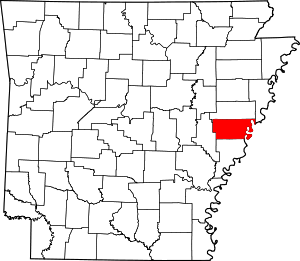
Location of Lee County in Arkansas
This is intended to be a complete list of the properties and districts on the National Register of Historic Places in Lee County, Arkansas, United States. The locations of National Register properties and districts for which the latitude and longitude coordinates are included below may be seen in a map.[1]
There are 12 properties and districts listed on the National Register in the county, including 1 National Historic Landmark. Another property was once listed but has been removed.
- This National Park Service list is complete through NPS recent listings posted August 14, 2020.[2]
Current listings
| [3] | Name on the Register[4] | Image | Date listed[5] | Location | City or town | Description |
|---|---|---|---|---|---|---|
| 1 | Elks Club | 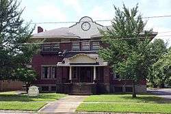 Elks Club |
July 27, 1979 (#79000445) |
67 W. Main St. 34°46′23″N 90°45′36″W |
Marianna | |
| 2 | Gen. Robert E. Lee Monument | 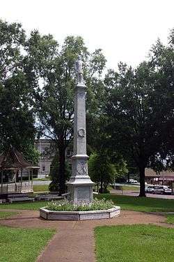 Gen. Robert E. Lee Monument |
May 10, 1996 (#96000450) |
City Park, roughly bounded by Court, Chestnut, and Main Sts. 34°46′26″N 90°45′25″W |
Marianna | |
| 3 | Lee County Courthouse |  Lee County Courthouse |
September 7, 1995 (#95001090) |
15 E. Chestnut St. 34°46′28″N 90°45′25″W |
Marianna | |
| 4 | Lee Grocery Store | February 13, 2020 (#100004897) |
100 Main St. 34°18′29″N 90°51′10″W |
Elaine | ||
| 5 | Louisiana Purchase Survey Marker | 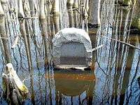 Louisiana Purchase Survey Marker |
February 23, 1972 (#72000206) |
Southeast of Blackton at the corner of Monroe and Phillips counties 34°38′48″N 91°03′05″W |
Blackton | Extends into Monroe and Phillips counties |
| 6 | Marianna Commercial Historic District | 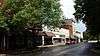 Marianna Commercial Historic District |
January 4, 2001 (#00001559) |
Portions of Chestnut, Liberty, East Columbia, Mississippi, Poplar, Main, Court, and Church Sts. 34°46′25″N 90°45′26″W |
Marianna | |
| 7 | Marianna Missouri-Pacific Depot | 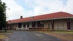 Marianna Missouri-Pacific Depot |
August 5, 1994 (#94000827) |
S. Carolina St. 34°46′14″N 90°45′39″W |
Marianna | |
| 8 | Marianna National Guard Armory | 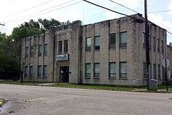 Marianna National Guard Armory |
January 24, 2007 (#06001267) |
45 W. Mississippi St. 34°46′22″N 90°45′32″W |
Marianna | |
| 9 | Marianna Waterworks | 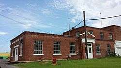 Marianna Waterworks |
January 24, 2007 (#06001281) |
252 U.S. Route 79 34°46′36″N 90°45′56″W |
Marianna | |
| 10 | McClintock House | 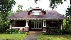 McClintock House |
December 22, 1982 (#82000857) |
43 Magnolia 34°46′30″N 90°45′37″W |
Marianna | Designed by Charles L. Thompson. |
| 11 | McClintock House | 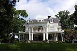 McClintock House |
December 28, 1977 (#77000261) |
82 W. Main St. 34°45′55″N 90°45′36″W |
Marianna | Designed by Charles L. Thompson. |
| 12 | John A. Plummer House | 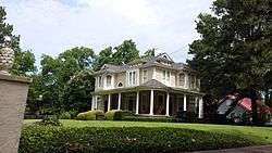 John A. Plummer House |
June 16, 1998 (#98000646) |
269 Pearl St. 34°46′52″N 90°45′43″W |
Marianna |
Former listing
| [3] | Name on the Register | Image | Date listed | Date removed | Location | City or town | Summary |
|---|---|---|---|---|---|---|---|
| 1 | Mixon-Evans Barn | November 18, 1999 (#99001349) | June 1, 2005 | 459 S. Alabama St. and Highway 1 Business, S. |
Marianna |
gollark: Its iterators are kind of æ and bad.
gollark: > you can still one line anything in python*Technically*, but not very idiomatically.
gollark: The indentation thing means I can't do really cool oneliners, thus bad.
gollark: I kind of like it but I also got used to curly brackets from writing other stuff.
gollark: PHP is not good. SolarFlame5 *will* be orbital-laser-struck.
See also
| Wikimedia Commons has media related to National Register of Historic Places in Lee County, Arkansas. |
References
- The latitude and longitude information provided in this table was derived originally from the National Register Information System, which has been found to be fairly accurate for about 99% of listings. Some locations in this table may have been corrected to current GPS standards.
- "National Register of Historic Places: Weekly List Actions". National Park Service, United States Department of the Interior. Retrieved on August 14, 2020.
- Numbers represent an ordering by significant words. Various colorings, defined here, differentiate National Historic Landmarks and historic districts from other NRHP buildings, structures, sites or objects.
- "National Register Information System". National Register of Historic Places. National Park Service. March 13, 2009.
- The eight-digit number below each date is the number assigned to each location in the National Register Information System database, which can be viewed by clicking the number.
| Topics | |
|---|---|
| Lists by state |
|
| Lists by insular areas | |
| Lists by associated state | |
| Other areas | |
| Related | |
| |
Municipalities and communities of Lee County, Arkansas, United States | ||
|---|---|---|
| City | Map of Arkansas highlighting Lee County | |
| Towns | ||
| Unincorporated communities | ||
| Footnotes | ‡This populated place also has portions in an adjacent county or counties | |
This article is issued from Wikipedia. The text is licensed under Creative Commons - Attribution - Sharealike. Additional terms may apply for the media files.