National Register of Historic Places listings in Drew County, Arkansas
This is a list of the National Register of Historic Places listings in Drew County, Arkansas.
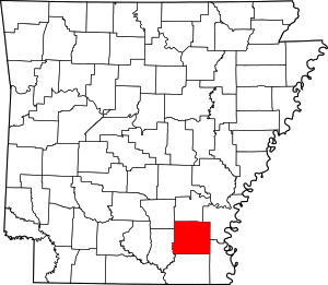
Location of Drew County in Arkansas
This is intended to be a complete list of the properties and districts on the National Register of Historic Places in Drew County, Arkansas, United States. The locations of National Register properties and districts for which the latitude and longitude coordinates are included below, may be seen in a map.[1]
There are 21 properties and districts listed on the National Register in the county.
- This National Park Service list is complete through NPS recent listings posted August 14, 2020.[2]
Current listings
| [3] | Name on the Register[4] | Image | Date listed[5] | Location | City or town | Description |
|---|---|---|---|---|---|---|
| 1 | Garvin Cavaness House | 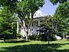 Garvin Cavaness House |
May 23, 1980 (#80000775) |
404 S. Main St. 33°37′22″N 91°47′30″W |
Monticello | |
| 2 | Drew County Courthouse | 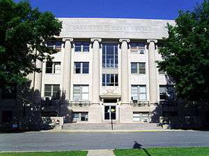 Drew County Courthouse |
October 17, 1997 (#97001226) |
210 S. Main St. 33°37′36″N 91°47′29″W |
Monticello | |
| 3 | Champ Grubbs House | 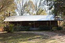 Champ Grubbs House |
November 20, 1992 (#92001619) |
Highway 172 west of New Hope 33°30′46″N 91°56′03″W |
New Hope | |
| 4 | Robert Lee Hardy House | 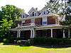 Robert Lee Hardy House |
April 26, 1982 (#82002113) |
207 S. Main St. 33°37′36″N 91°47′26″W |
Monticello | |
| 5 | Hotchkiss House | 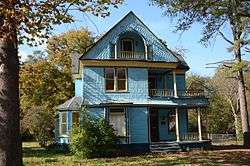 Hotchkiss House |
December 12, 1976 (#76000404) |
509 N. Boyd St. 33°37′53″N 91°47′39″W |
Monticello | |
| 6 | Jerome Elementary School No. 22 | 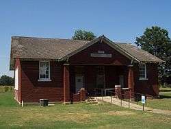 Jerome Elementary School No. 22 |
September 28, 2005 (#05001068) |
N. Louisiana Boulevard 33°24′11″N 91°28′08″W |
Jerome | |
| 7 | Lambert House | 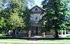 Lambert House |
December 22, 1983 (#83003545) |
204 W. Jackson St. 33°37′35″N 91°47′34″W |
Monticello | |
| 8 | Look See Tree |  Look See Tree |
January 23, 2008 (#07001427) |
Southwestern corner of the junction of Highway 83 and Pleasant Springs Rd. 33°47′10″N 91°44′59″W |
Coleman | |
| 9 | Monticello Commercial Historic District | 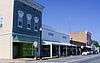 Monticello Commercial Historic District |
September 23, 2011 (#11000688) |
Bounded roughly by Trotter Ave., Edwards St., Railroad Ave. & Chester St. 33°37′46″N 91°47′27″W |
Monticello | |
| 10 | Monticello Confederate Monument | 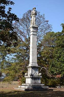 Monticello Confederate Monument |
April 26, 1996 (#96000449) |
Oakland Cemetery, east of the junction of Oakland Ave. and Hyatt St. 33°38′04″N 91°47′52″W |
Monticello | |
| 11 | Monticello North Main Street Historic District | 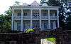 Monticello North Main Street Historic District |
February 18, 1979 (#79000437) |
Irregular pattern along Westwood Ave. and N. Main St. 33°38′01″N 91°47′27″W |
Monticello | |
| 12 | Monticello Post Office | 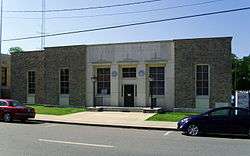 Monticello Post Office |
August 14, 1998 (#98000920) |
211 W. Gaines St. 33°37′46″N 91°47′31″W |
Monticello | |
| 13 | Ridgeway Hotel Historic District | 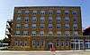 Ridgeway Hotel Historic District |
January 22, 2009 (#08000952) |
200-206 E. Gaines St. 33°37′44″N 91°47′24″W |
Monticello | |
| 14 | Rough and Ready Cemetery | 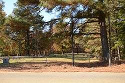 Rough and Ready Cemetery |
November 22, 1999 (#99001376) |
Approximately 1 mile southeast of the Monticello Civic Center on Highway 19 33°36′50″N 91°47′21″W |
Monticello | |
| 15 | St. Mary's Episcopal Church | 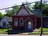 St. Mary's Episcopal Church |
April 4, 1996 (#96000352) |
115 S. Main St. 33°37′39″N 91°47′26″W |
Monticello | |
| 16 | Saline Cemetery | 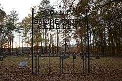 Saline Cemetery |
June 15, 2011 (#11000353) |
.3 miles south of the junction of US 278 & Allis Rd. 33°37′11″N 91°54′30″W |
Wilmar vicinity | |
| 17 | Selma Methodist Church | 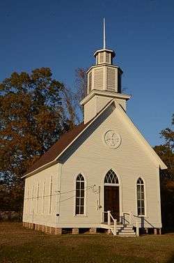 Selma Methodist Church |
September 22, 1972 (#72000202) |
North of Highway 4 in Selma 33°41′52″N 91°34′11″W |
Selma | |
| 18 | Selma Rosenwald School | 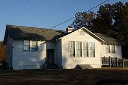 Selma Rosenwald School |
March 2, 2006 (#06000069) |
Selma-Collins Rd., approximately 0.25 miles south of U.S. Route 278 33°40′30″N 91°33′58″W |
Selma | |
| 19 | Taylor Log House and Site | 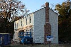 Taylor Log House and Site |
October 16, 1995 (#95001168) |
Highway 138 west of Winchester 33°46′11″N 91°33′04″W |
Winchester | |
| 20 | Frank Tillar Memorial Methodist Episcopal Church, South | 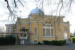 Frank Tillar Memorial Methodist Episcopal Church, South |
June 4, 1997 (#97000525) |
W. Railroad St., north of Highway 277 33°42′37″N 91°27′13″W |
Tillar | |
| 21 | Veasey-DeArmond House | September 14, 1989 (#89001424) |
Highway 81, 15 miles north of Monticello 33°30′41″N 91°51′31″W |
Lacey |
gollark: When I do "work" I like to listen to the Doom soundtrack.
gollark: Also, no swearing for some reason?
gollark: It's just heavy metal but they say vaguely god-y/Christian things.
gollark: I see.
gollark: That sounds intensely annoying.
See also
| Wikimedia Commons has media related to National Register of Historic Places in Drew County, Arkansas. |
References
- The latitude and longitude information provided in this table was derived originally from the National Register Information System, which has been found to be fairly accurate for about 99% of listings. Some locations in this table may have been corrected to current GPS standards.
- "National Register of Historic Places: Weekly List Actions". National Park Service, United States Department of the Interior. Retrieved on August 14, 2020.
- Numbers represent an ordering by significant words. Various colorings, defined here, differentiate National Historic Landmarks and historic districts from other NRHP buildings, structures, sites or objects.
- "National Register Information System". National Register of Historic Places. National Park Service. March 13, 2009.
- The eight-digit number below each date is the number assigned to each location in the National Register Information System database, which can be viewed by clicking the number.
| Topics | |
|---|---|
| Lists by state |
|
| Lists by insular areas | |
| Lists by associated state | |
| Other areas | |
| Related | |
| |
Municipalities and communities of Drew County, Arkansas, United States | ||
|---|---|---|
| Cities | Map of Arkansas highlighting Drew County | |
| Towns | ||
| Unincorporated communities | ||
| Footnotes | ‡This populated place also has portions in an adjacent county or counties | |
This article is issued from Wikipedia. The text is licensed under Creative Commons - Attribution - Sharealike. Additional terms may apply for the media files.