National Register of Historic Places listings in Pulaski County, Arkansas
This is a list of the National Register of Historic Places listings in Pulaski County, Arkansas.
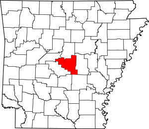
This is intended to be a complete list of the properties and districts on the National Register of Historic Places in Pulaski County, Arkansas, United States. The locations of National Register properties and districts for which the latitude and longitude coordinates are included below, may be seen in a map.[1]
There are 338 properties and districts listed on the National Register in the county, including 5 National Historic Landmarks. The 81 properties and districts that are located outside of Little Rock (including one National Historic Landmark) are listed here, while the sites in Little Rock are listed separately. Another 21 properties in the county have been removed, including 5 outside Little Rock.
- This National Park Service list is complete through NPS recent listings posted August 14, 2020.[2]
Current listings
Little Rock
Exclusive of Little Rock
| [3] | Name on the Register[4] | Image | Date listed[5] | Location | City or town | Description |
|---|---|---|---|---|---|---|
| 1 | All Souls Church |  All Souls Church |
August 12, 1977 (#77000275) |
Off Highway 130 34°41′56″N 92°05′47″W |
Scott | |
| 2 | Bailey Allinder House |  Bailey Allinder House |
December 27, 2002 (#02001600) |
301 Skyline Dr. 34°46′52″N 92°15′29″W |
North Little Rock | |
| 3 | Amboy Overpass |  Amboy Overpass |
May 18, 1995 (#95000608) |
Highway 365 over Union Pacific railroad tracks, north of the junction of Highways 176 and 365 34°48′05″N 92°17′30″W |
North Little Rock | |
| 4 | Argenta Historic District |  Argenta Historic District |
March 15, 1993 (#93000094) |
Roughly Melrose Cir. and Willow St. south to W. 4th St., and Main St. from W. 6th St. to W. 3rd St.; also 616 Orange St., 116 W. 7th St., 206 W. 7th St., 212 W. 7th St., 220 W. 7th St., 616 Maple St., and 620 Maple St.; also roughly bounded by N. Poplar, 9th St., N. Broadway, W. 4th, and Broadway 34°45′32″N 92°16′11″W |
North Little Rock | Second and third sets of boundaries represent boundary increases of February 22, 2002 and March 8, 2007 respectively |
| 5 | ARKANSAS II (riverboat) | June 14, 1990 (#90000899) |
Southern end of Locust St. on David D. Terry Lake 34°45′05″N 92°15′41″W |
North Little Rock | ||
| 6 | Arkansas Ordnance Plant Guard House | 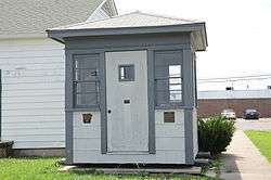 Arkansas Ordnance Plant Guard House |
September 20, 2006 (#06000831) |
100 Veteran's Circle 34°52′03″N 92°07′22″W |
Jacksonville | On the grounds of the Jacksonville Museum of Military History |
| 7 | Carl Bailey Company Building | 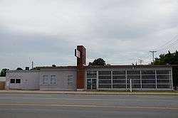 Carl Bailey Company Building |
September 23, 2009 (#09000737) |
3100 E. Broadway 34°45′17″N 92°13′55″W |
North Little Rock | |
| 8 | Baker House | 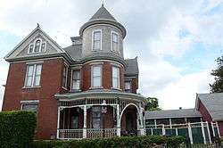 Baker House |
December 6, 1978 (#78000627) |
109 5th St. 34°45′30″N 92°16′05″W |
North Little Rock | |
| 9 | Barth-Hempfling House | 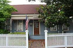 Barth-Hempfling House |
October 16, 1986 (#86002860) |
507 Main St. 34°46′03″N 92°16′03″W |
North Little Rock | |
| 10 | Bayou Meto (Reed's Bridge) Battlefield | _Battlefield%2C_US_Cannons.JPG) Bayou Meto (Reed's Bridge) Battlefield |
December 31, 2002 (#02001627) |
Highway 161 at Bayou Meto 34°50′44″N 92°07′06″W |
Jacksonville | |
| 11 | Cecil M. Buffalo Jr. House | September 17, 2018 (#100002951) |
16324 Arch Street Pike 34°38′27″N 92°18′33″W |
Landmark | ||
| 12 | Carmichael House | May 24, 2018 (#100002478) |
13905 Arch Street Pike 34°37′27″N 92°18′49″W |
Landmark | ||
| 13 | Cherry House | 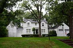 Cherry House |
June 1, 1992 (#92000562) |
217 Dooley Rd. 34°46′54″N 92°15′23″W |
North Little Rock | Designed by Frank Carmean |
| 14 | Cherry-Luter Estate | 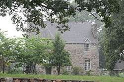 Cherry-Luter Estate |
September 4, 1992 (#92001155) |
521 W. Scenic Dr. 34°47′03″N 92°17′23″W |
North Little Rock | |
| 15 | CITY OF OAKLAND (USS HOGA) | 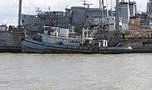 CITY OF OAKLAND (USS HOGA) |
June 30, 1989 (#89001429) |
Arkansas Inland Maritime Museum 34°45′09″N 92°16′04″W |
North Little Rock | Tugboat; at Pearl Harbor fought ship fires and helped push sinking USS Nevada out of the ship channel; served Oakland harbor for many years; The vessel was transferred to the Arkansas Inland Maritime Museum (AIMM) in 2005[6] and was scheduled to be moved to North Little Rock, Arkansas in 2007. The move has been delayed by damage from Hurricane Katrina along the proposed tow route to AIMM and transport costs.[7] She was moved to the Arkansas Inland Maritime Museum in November 2015. |
| 16 | Crestview Park | 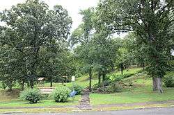 Crestview Park |
December 4, 1986 (#86003583) |
Off Crestview Boulevard[8] 34°46′56″N 92°15′53″W |
North Little Rock | |
| 17 | Doe Branch Post Office | 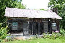 Doe Branch Post Office |
January 26, 2001 (#01000003) |
32100 Kanis Rd. 34°47′16″N 92°35′38″W |
Ferndale | |
| 18 | Duffy House | 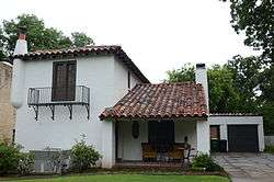 Duffy House |
September 29, 2014 (#14000793) |
124 E. A St. 34°46′58″N 92°15′34″W |
North Little Rock | |
| 19 | East End Methodist Episcopal Church | 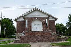 East End Methodist Episcopal Church |
November 12, 2008 (#08001038) |
2401 E. Washington Ave. 34°45′14″N 92°14′26″W |
North Little Rock | |
| 20 | Edgemere Street Bridge | 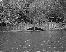 Edgemere Street Bridge |
April 9, 1990 (#90000533) |
Edgemere St., at Lake No. 3 34°47′40″N 92°15′00″W |
North Little Rock | |
| 21 | Barney L. Elias House | 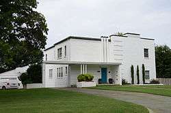 Barney L. Elias House |
January 27, 2015 (#14001201) |
335 Goshen Ave. 34°47′02″N 92°15′04″W |
North Little Rock | |
| 22 | Engelberger House | 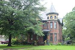 Engelberger House |
June 14, 1990 (#90000895) |
2105 N. Maple St. 34°46′28″N 92°16′06″W |
North Little Rock | |
| 23 | Joseph E. England Jr. House | 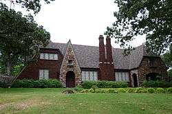 Joseph E. England Jr. House |
June 1, 1992 (#92000566) |
313 Skyline Dr. 34°46′53″N 92°15′29″W |
North Little Rock | |
| 24 | Faucette Building | 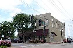 Faucette Building |
December 6, 1978 (#78000628) |
4th and Main Sts. 34°45′26″N 92°16′01″W |
North Little Rock | |
| 25 | James Peter Faucette House | 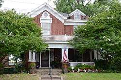 James Peter Faucette House |
January 4, 1978 (#78000629) |
316 W. 4th St. 34°45′25″N 92°16′15″W |
North Little Rock | |
| 26 | First Presbyterian Church Manse | 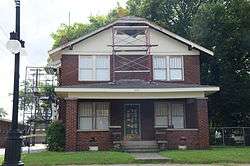 First Presbyterian Church Manse |
November 19, 1993 (#93001251) |
415 N. Maple St. 34°45′30″N 92°16′09″W |
North Little Rock | |
| 27 | Fort Logan H. Roots Military Post | 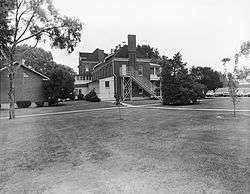 Fort Logan H. Roots Military Post |
September 4, 1974 (#74000498) |
Scenic Hill Dr. 34°46′26″N 92°17′42″W |
North Little Rock | |
| 28 | Frenchman's Mountain Methodist Episcopal Church-South and Cemetery | 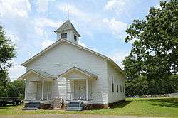 Frenchman's Mountain Methodist Episcopal Church-South and Cemetery |
October 22, 1976 (#76000450) |
West of Cato on Cato Rd. 34°55′41″N 92°15′53″W |
Cato | |
| 29 | Hanger Cotton Gin | 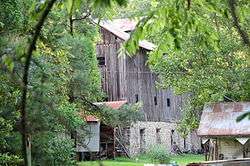 Hanger Cotton Gin |
October 8, 1976 (#76000463) |
Harper Rd. and Gates Lane 34°41′11″N 92°14′12″W |
Sweet Home | |
| 30 | Harris House | January 1, 1976 (#76000451) |
Southeast of Hensley off Highway 365 34°29′40″N 92°10′07″W |
Hensley | ||
| 31 | Hodge-Cook House | 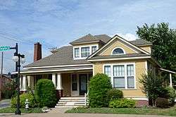 Hodge-Cook House |
November 19, 1993 (#93001252) |
620 N. Maple St. 34°45′36″N 92°16′07″W |
North Little Rock | |
| 32 | Howell-Garner-Monfee House | 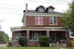 Howell-Garner-Monfee House |
January 4, 1978 (#78000630) |
300 W. 4th St. 34°45′25″N 92°16′13″W |
North Little Rock | |
| 33 | George D.D. Huie Grocery Store Building | 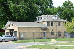 George D.D. Huie Grocery Store Building |
January 20, 2005 (#04001504) |
1400 N. Pine St. 34°46′01″N 92°15′37″W |
North Little Rock | |
| 34 | Immaculate Heart of Mary Church | 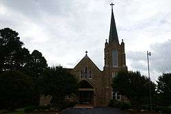 Immaculate Heart of Mary Church |
December 22, 1982 (#82000901) |
North of North Little Rock off Highway 365 34°52′36″N 92°20′32″W |
North Little Rock | |
| 35 | Immaculate Heart of Mary School | 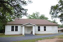 Immaculate Heart of Mary School |
September 16, 1993 (#93000965) |
Off Highway 365, north of Blue Hill Rd. 34°52′35″N 92°20′26″W |
Marche | |
| 36 | Jacksonville Commercial Historic District | 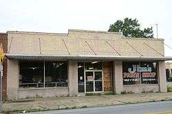 Jacksonville Commercial Historic District |
February 8, 2016 (#15000631) |
1st from Mulberry to W. Hickory Sts. 34°51′57″N 92°06′39″W |
Jacksonville | |
| 37 | Jeffries House | 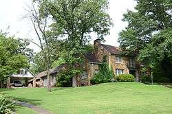 Jeffries House |
June 1, 1992 (#92000567) |
415 Skyline Dr. 34°46′50″N 92°15′21″W |
North Little Rock | |
| 38 | Dr. Charles H. Kennedy House | September 21, 2017 (#100001651) |
6 Edenwood Ln. 34°49′01″N 92°14′53″W |
North Little Rock | ||
| 39 | Kleiber House | 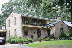 Kleiber House |
June 1, 1992 (#92000561) |
637 Skyline Dr. 34°46′55″N 92°15′16″W |
North Little Rock | |
| 40 | Lake No. 1 Bridge | 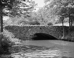 Lake No. 1 Bridge |
April 9, 1990 (#90000534) |
Avondale Rd., over Lake No. 1 34°47′20″N 92°15′08″W |
North Little Rock | |
| 41 | Lakeshore Drive Bridge | 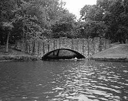 Lakeshore Drive Bridge |
April 9, 1990 (#90000532) |
Lakeshore Dr. at Lake No. 3 34°47′41″N 92°15′06″W |
North Little Rock | |
| 42 | Lakewood Park |  Lakewood Park |
December 4, 1986 (#86003586) |
North end of Lake No. 3 34°47′50″N 92°15′05″W |
North Little Rock | |
| 43 | Land's End Plantation | 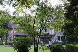 Land's End Plantation |
January 27, 1999 (#99000044) |
1 Land's End Ln. 34°53′36″N 92°07′08″W |
Scott | |
| 44 | Lloyd England Hall | May 9, 1997 (#97000403) |
Northwestern corner of the junction of Missouri Ave. and 6th St. 34°49′31″N 92°17′13″W |
North Little Rock | Houses the Arkansas National Guard Museum | |
| 45 | E. O. Manees House | 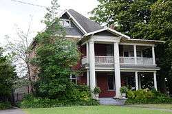 E. O. Manees House |
August 6, 1975 (#75000413) |
216 W. 4th St. 34°45′24″N 92°16′11″W |
North Little Rock | |
| 46 | Matthews House | 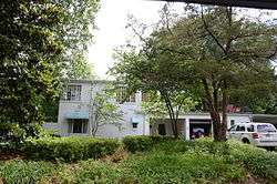 Matthews House |
September 29, 1983 (#83001165) |
406 Goshen 34°45′54″N 92°15′02″W |
North Little Rock | |
| 47 | Justin Matthews Jr. House | 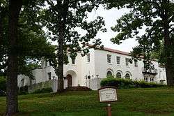 Justin Matthews Jr. House |
December 18, 1990 (#90001933) |
257 Skyline Dr. 34°46′54″N 92°15′30″W |
North Little Rock | |
| 48 | Matthews-Bradshaw House | 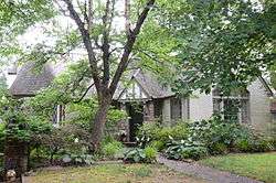 Matthews-Bradshaw House |
June 1, 1992 (#92000568) |
524 Skyline Dr. 34°46′47″N 92°15′17″W |
North Little Rock | |
| 49 | Matthews-Bryan House | 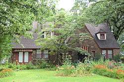 Matthews-Bryan House |
June 1, 1992 (#92000560) |
320 Dooley Rd. 34°46′51″N 92°15′15″W |
North Little Rock | |
| 50 | Matthews-Dillon House |  Matthews-Dillon House |
June 1, 1992 (#92000563) |
701 Skyline Dr. 34°46′55″N 92°15′21″W |
North Little Rock | |
| 51 | Matthews-Godt House | 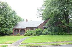 Matthews-Godt House |
June 1, 1992 (#92000565) |
248 Skyline Dr. 34°46′55″N 92°15′32″W |
North Little Rock | |
| 52 | Matthews-MacFadyen House | 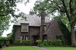 Matthews-MacFadyen House |
June 1, 1992 (#92000569) |
206 Dooley Rd. 34°46′52″N 92°15′23″W |
North Little Rock | |
| 53 | Maumelle Ordnance Works Bunker #4 | 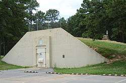 Maumelle Ordnance Works Bunker #4 |
May 24, 2006 (#06000417) |
4 Willastein Dr. 34°51′16″N 92°24′46″W |
Maumelle | |
| 54 | Maumelle River Bridge | 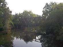 Maumelle River Bridge |
January 21, 2020 (#100004894) |
Old AR 300 over the Maumelle River 34°51′05″N 92°29′00″W |
Natural Steps vicinity | |
| 54 | McCraw Cemetery | 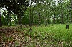 McCraw Cemetery |
September 20, 2006 (#06000829) |
East of 2101 Old Military Rd. 34°51′10″N 92°05′15″W |
Jacksonville | |
| 55 | McKenzie House | 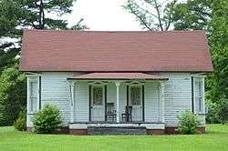 McKenzie House |
March 5, 1992 (#92000105) |
4911 Highway 161 34°41′39″N 92°05′48″W |
Scott | |
| 56 | North Little Rock City Hall |  North Little Rock City Hall |
August 6, 1975 (#75000414) |
3rd and Main Sts. 34°45′22″N 92°16′02″W |
North Little Rock | |
| 57 | North Little Rock High School | 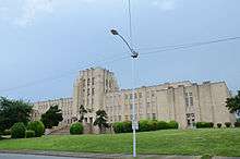 North Little Rock High School |
February 25, 1993 (#92001625) |
101 W. 22nd St. 34°46′34″N 92°16′05″W |
North Little Rock | |
| 58 | North Little Rock Post Office | 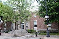 North Little Rock Post Office |
December 22, 1982 (#82000915) |
420 N. Main St. 34°45′28″N 92°16′02″W |
North Little Rock | Now houses the Argenta Branch Library |
| 59 | North Little Rock Veterans Administration Hospital Historic District | 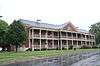 North Little Rock Veterans Administration Hospital Historic District |
February 20, 2013 (#13000021) |
2200 Fort Roots Dr. 34°46′40″N 92°17′50″W |
North Little Rock | |
| 60 | Old Central Fire Station | 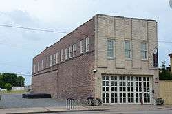 Old Central Fire Station |
December 22, 1977 (#77000274) |
506 Main St. 34°45′30″N 92°16′02″W |
North Little Rock | |
| 61 | Owings House | 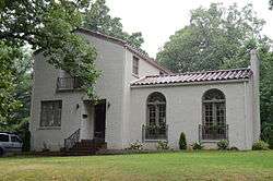 Owings House |
June 1, 1992 (#92000564) |
563 Skyline Dr. 34°46′50″N 92°15′13″W |
North Little Rock | |
| 62 | Palarm Bayou Pioneer Cemetery | January 20, 2005 (#04001491) |
Lot 13 in the Mountain Crest Subdivision, northeast of Highway 365 34°54′01″N 92°26′23″W |
Morgan | The Mountain Crest Subdivision is a gated community. | |
| 63 | Park Hill Fire Station and Water Company Complex | 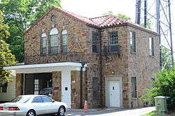 Park Hill Fire Station and Water Company Complex |
November 19, 1993 (#93001248) |
3417-3421 Magnolia St. 34°47′13″N 92°15′52″W |
North Little Rock | |
| 64 | Park Hill Historic District | 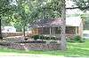 Park Hill Historic District |
August 16, 2000 (#00000935) |
Roughly bounded by Plainview Circle, Crestview Boulevard, Ridge St., and H Ave. 34°47′09″N 92°15′40″W |
North Little Rock | |
| 65 | Pruniski House | 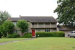 Pruniski House |
February 9, 1990 (#90000116) |
345 Goshen Ave. 34°47′07″N 92°15′12″W |
North Little Rock | |
| 66 | T. R. Pugh Memorial Park | 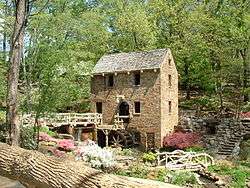 T. R. Pugh Memorial Park |
December 4, 1986 (#86003585) |
Near the junction of Fairway Ave. and Lakeshore Dr.[9] 34°47′30″N 92°14′57″W |
North Little Rock | |
| 67 | Pyeatte-Mason Cemetery | 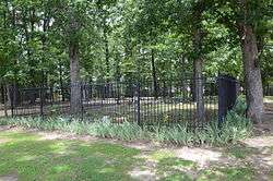 Pyeatte-Mason Cemetery |
November 7, 1996 (#96001276) |
Southwestern corner of the junction of Waterside and Lily Sts. 34°51′07″N 92°25′10″W |
Maumelle | |
| 68 | Rapillard House | 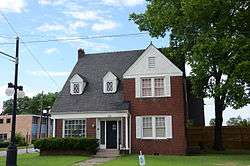 Rapillard House |
November 19, 1993 (#93001249) |
123 W. 7th St. 34°45′39″N 92°16′06″W |
North Little Rock | |
| 69 | Rock Island-Argenta Depot | 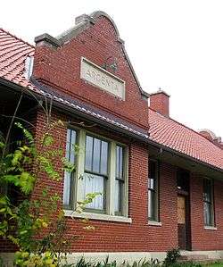 Rock Island-Argenta Depot |
September 21, 1989 (#89001403) |
4th and Hazel 34°45′24″N 92°15′13″W |
North Little Rock | |
| 70 | Roundtop Filling Station | 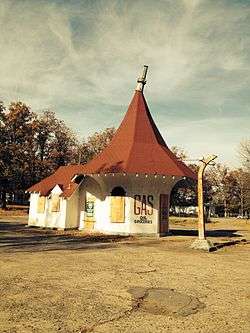 Roundtop Filling Station |
January 24, 2008 (#07001432) |
Junction of Trammel and Roundtop Rds. 34°48′44″N 92°10′42″W |
Sherwood | |
| 71 | Gene Rush House | January 24, 2019 (#100003335) |
9515 Barrett Rd. 34°50′13″N 92°31′18″W |
Roland | ||
| 72 | St. Joseph's Home | 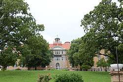 St. Joseph's Home |
May 4, 1976 (#76000462) |
Camp Robinson Rd. off Highway 176 34°48′59″N 92°16′17″W |
North Little Rock | |
| 73 | Fred and Lucy Alexander Schaer House | 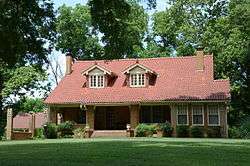 Fred and Lucy Alexander Schaer House |
September 27, 2007 (#07000993) |
13219 U.S. Route 70 34°46′25″N 92°07′07″W |
Galloway | |
| 74 | Seed Warehouse No. 5 | 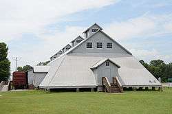 Seed Warehouse No. 5 |
January 21, 2010 (#09001259) |
Southwestern corner of U.S. Route 165 and Highway 161 34°41′47″N 92°05′47″W |
Scott | |
| 75 | Sam and Shirley Strauss House | 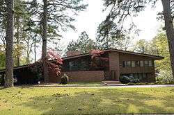 Sam and Shirley Strauss House |
September 28, 2015 (#15000634) |
4 Sunset Dr. 34°47′02″N 92°20′53″W |
Cammack Village | |
| 76 | Sylvan Hills Country Club Golf Course | 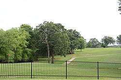 Sylvan Hills Country Club Golf Course |
July 28, 2010 (#10000289) |
7400 North Highway 107 34°49′20″N 92°13′39″W |
Sherwood | |
| 77 | USS RAZORBACK (SS-394) |  USS RAZORBACK (SS-394) |
September 1, 2005 (#04001502) |
Northern bank of the Arkansas River in the vicinity of an Interstate 30 bridge 34°45′13″N 92°15′49″W |
North Little Rock | WWII U.S. submarine that served Turkey |
| 78 | Walnut Grove Methodist Church |  Walnut Grove Methodist Church |
September 28, 1977 (#77000273) |
West of Little Rock on Walnut Grove Rd. 34°46′00″N 92°30′42″W |
Shady Grove | |
| 79 | Waterside Street Bridge | 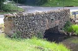 Waterside Street Bridge |
June 14, 1990 (#90000888) |
Waterside St. near its junction with Jacksonville Boulevard 34°46′59″N 92°14′46″W |
North Little Rock | |
| 80 | West-Blazer House | September 21, 2017 (#100001652) |
8107 Peters Rd. 34°56′24″N 92°05′24″W |
Jacksonville |
Former listings
| [3] | Name on the Register | Image | Date listed | Date removed | Location | City or town | Summary |
|---|---|---|---|---|---|---|---|
| 1 | Cook House | November 19, 1993 (#93001250) | September 14, 2002 | 116 W. 7th Street |
North Little Rock | ||
| 2 | Pulaski County Road 67D Bridge | May 26, 1995 (#95000651) | July 20, 2000 | Co. Rd. 67D over Bridge Cr. |
Jacksonville | A concrete slab bridge. Replaced in 2000. | |
| 3 | Pulaski County Road 71D Bridge | May 26, 1995 (#95000652) | January 14, 2002 | County Road 71D over Bayou Meto |
Jacksonville | ||
| 4 | Wolf Bayou Bridge | May 26, 2004 (#04000502) | May 25, 2006 | Pulaski County Road 85 |
Scott | A Warren pony-truss bridge from 1924. Replaced in 2006. | |
| 5 | Young House | June 1, 1992 (#92000559) | January 24, 2011 | 436 Skyline Dr. 34°46′48″N 92°15′30″W |
North Little Rock |
See also
| Wikimedia Commons has media related to National Register of Historic Places in Pulaski County, Arkansas. |
References
- The latitude and longitude information provided in this table was derived originally from the National Register Information System, which has been found to be fairly accurate for about 99% of listings. Some locations in this table may have been corrected to current GPS standards.
- "National Register of Historic Places: Weekly List Actions". National Park Service, United States Department of the Interior. Retrieved on August 14, 2020.
- Numbers represent an ordering by significant words. Various colorings, defined here, differentiate National Historic Landmarks and historic districts from other NRHP buildings, structures, sites or objects.
- "National Register Information System". National Register of Historic Places. National Park Service. March 13, 2009.
- The eight-digit number below each date is the number assigned to each location in the National Register Information System database, which can be viewed by clicking the number.
- "National Historic Landmarks Program: City of Oakland (USS Hoga) (Tug)". National Park Service. Archived from the original on June 6, 2011. Retrieved April 29, 2009.
- "America's 11 Most Endangered Historic Places". National Trust for Historic Preservation. Retrieved 2 July 2009.
- Location derived from its profile from the Arkansas Historic Preservation Program website; the NRIS lists the site as "Address Restricted"
- Location derived from this community webpage; the NRIS lists the site as "Address Restricted"
| Topics | |
|---|---|
| Lists by state |
|
| Lists by insular areas | |
| Lists by associated state | |
| Other areas | |
| Related | |
| |
Municipalities and communities of Pulaski County, Arkansas, United States | ||
|---|---|---|
| Cities | Map of Arkansas highlighting Pulaski County | |
| CDPs | ||
| Unincorporated communities | ||
| Footnotes | ‡This populated place also has portions in an adjacent county or counties | |