National Register of Historic Places listings in Pike County, Arkansas
This is a list of the National Register of Historic Places listings in Pike County, Arkansas.
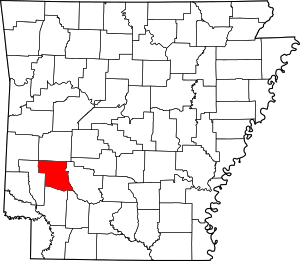
Location of Pike County in Arkansas
This is intended to be a complete list of the properties on the National Register of Historic Places in Pike County, Arkansas, United States. The locations of National Register properties for which the latitude and longitude coordinates are included below, may be seen in a map.[1]
There are 9 properties listed on the National Register in the county.
- This National Park Service list is complete through NPS recent listings posted August 14, 2020.[2]
Current listings
| [3] | Name on the Register[4] | Image | Date listed[5] | Location | City or town | Description |
|---|---|---|---|---|---|---|
| 1 | Conway Hotel | 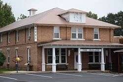 Conway Hotel |
March 6, 1986 (#86000384) |
108 Courthouse Sq. 34°03′46″N 93°40′33″W |
Murfreesboro | |
| 2 | Crater of Diamonds State Park | .jpg) Crater of Diamonds State Park |
June 18, 1973 (#73000386) |
Southeast of Murfreesboro 34°02′03″N 93°40′22″W |
Murfreesboro | |
| 3 | Glenwood Iron Mountain Railroad Depot | 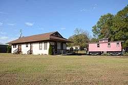 Glenwood Iron Mountain Railroad Depot |
June 28, 1996 (#96000692) |
West of the junction of a Union Pacific Railroad line and U.S. Route 70 34°19′17″N 93°32′45″W |
Glenwood | |
| 4 | Jones General Store and Esso Station | 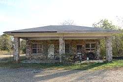 Jones General Store and Esso Station |
June 13, 2000 (#00000609) |
Highway 84, W. 34°18′42″N 93°51′03″W |
Langley | |
| 5 | Murfreesboro Cities Service Station | 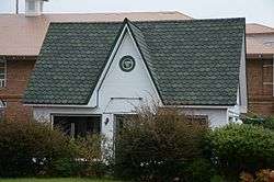 Murfreesboro Cities Service Station |
May 19, 2003 (#03000400) |
Northeastern side of the town square 34°03′45″N 93°41′22″W |
Murfreesboro | |
| 6 | Pike County Courthouse |  Pike County Courthouse |
October 16, 1986 (#86002863) |
Courthouse Sq. 34°03′43″N 93°41′23″W |
Murfreesboro | |
| 7 | Rosenwald School | 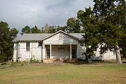 Rosenwald School |
September 17, 1990 (#90001381) |
Highway 26 34°02′13″N 93°27′17″W |
Delight | |
| 8 | Self Creek Bridge | 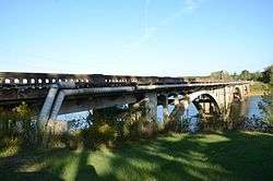 Self Creek Bridge |
June 9, 2000 (#00000635) |
U.S. Route 70 across Self Creek and Lake Greeson 34°14′11″N 93°45′24″W |
Daisy | |
| 9 | Shelton-Lockeby House | 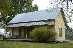 Shelton-Lockeby House |
September 28, 2005 (#05001079) |
Springhill Church Rd. 34°03′28″N 93°44′43″W |
Murfreesboro |
Former listings
| [3] | Name on the Register | Image | Date listed | Date removed | Location | City or town | Summary |
|---|---|---|---|---|---|---|---|
| 1 | O'Neel-Blackburn House | June 18, 1973 (#76000446) | October 4, 1999 | W of Daisy off U.S. 70 |
Daisy vicinity |
gollark: It probably *would* enhance the sense of confusion if there was a link at the start saying "view in alternative formats: HTML, JSON, SQLite3, XML, XHTML, TOML, base2048, brotli, Rust".
gollark: Yes, that is the correct way.
gollark: hmm, maybe I should migrate the potatOS privacy policy to this.
gollark: A zstandard compressed SQLite DB would be kind of weird honestly. Not seekable.
gollark: Maybe rating, description, genre, word count, sort of thing.
See also
| Wikimedia Commons has media related to National Register of Historic Places in Pike County, Arkansas. |
References
- The latitude and longitude information provided in this table was derived originally from the National Register Information System, which has been found to be fairly accurate for about 99% of listings. Some locations in this table may have been corrected to current GPS standards.
- "National Register of Historic Places: Weekly List Actions". National Park Service, United States Department of the Interior. Retrieved on August 14, 2020.
- Numbers represent an ordering by significant words. Various colorings, defined here, differentiate National Historic Landmarks and historic districts from other NRHP buildings, structures, sites or objects.
- "National Register Information System". National Register of Historic Places. National Park Service. March 13, 2009.
- The eight-digit number below each date is the number assigned to each location in the National Register Information System database, which can be viewed by clicking the number.
| Topics | |
|---|---|
| Lists by state |
|
| Lists by insular areas | |
| Lists by associated state | |
| Other areas | |
| Related | |
| |
Municipalities and communities of Pike County, Arkansas, United States | ||
|---|---|---|
| Cities | Map of Arkansas highlighting Pike County | |
| Towns | ||
| CDP | ||
| Unincorporated communities | ||
| Footnotes | ‡This populated place also has portions in an adjacent county or counties | |
This article is issued from Wikipedia. The text is licensed under Creative Commons - Attribution - Sharealike. Additional terms may apply for the media files.