National Register of Historic Places listings in Cape Girardeau County, Missouri
This is a list of the National Register of Historic Places listings in Cape Girardeau County, Missouri.
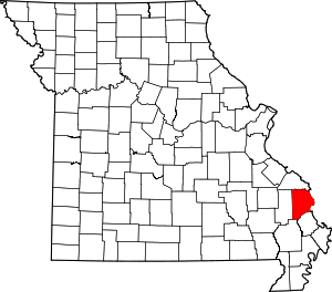
Location of Cape Girardeau County in Missouri
This is intended to be a complete list of the properties and districts on the National Register of Historic Places in Cape Girardeau County, Missouri, United States. Latitude and longitude coordinates are provided for many National Register properties and districts; these locations may be seen together in a map.[1]
There are 58 properties and districts listed on the Nationala Register in the county.
- This National Park Service list is complete through NPS recent listings posted August 14, 2020.[2]
Current listings
| [3] | Name on the Register | Image | Date listed[4] | Location | City or town | Description |
|---|---|---|---|---|---|---|
| 1 | B'Nai Israel Synagogue | 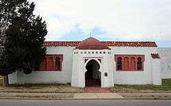 B'Nai Israel Synagogue |
May 5, 2004 (#04000385) |
121 S. Main St. 37°18′04″N 89°31′09″W |
Cape Girardeau | |
| 2 | Bainbridge Ferry | June 21, 2007 (#07000573) |
County Road 630 37°24′43″N 89°26′16″W |
Cape Girardeau | ||
| 3 | Bainbridge Ferry Rd. | June 21, 2007 (#07000577) |
County Road 623 37°26′11″N 89°28′07″W |
Cape Girardeau | ||
| 4 | Bennett-Tobler-Pace-Oliver House | 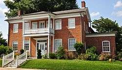 Bennett-Tobler-Pace-Oliver House |
April 18, 1985 (#85000853) |
224 E. Adams 37°22′54″N 89°39′56″W |
Jackson | |
| 5 | Big Hill Farmstead Historic District | December 22, 1999 (#99001598) |
2246 Route PP 37°21′49″N 89°41′26″W |
Jackson | ||
| 6 | Broadway Commercial Historic District | 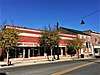 Broadway Commercial Historic District |
September 6, 2016 (#15001017) |
600, 700 & 800 blocks of Broadway & 210 N. Ellis St. 37°18′24″N 89°31′39″W |
Cape Girardeau | |
| 7 | Broadway Theatre | 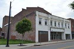 Broadway Theatre |
June 15, 2015 (#15000354) |
805 Broadway St. 37°18′24″N 89°31′42″W |
Cape Girardeau | |
| 8 | Broadway and North Fountain Street Historic District | 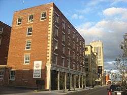 Broadway and North Fountain Street Historic District |
July 15, 2003 (#03000654) |
320-400 Broadway St. and 221 N. Fountain St. 37°18′23″N 89°31′20″W |
Cape Girardeau | |
| 9 | Broadway-Middle Commercial Historic District | 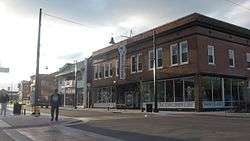 Broadway-Middle Commercial Historic District |
July 24, 2007 (#07000753) |
500 block of Broadway St. and 100 block of N. Middle St.; also south side 400 block of Broadway 37°18′24″N 89°31′27″W |
Cape Girardeau | Second set of boundaries represents a boundary increase of September 4, 2013 |
| 10 | Burfordville Covered Bridge | 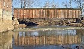 Burfordville Covered Bridge |
May 19, 1970 (#70000325) |
Eastern edge of Burfordville on County Road HH 37°22′02″N 89°48′09″W |
Burfordville | |
| 11 | Burfordville Mill | 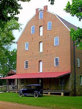 Burfordville Mill |
May 27, 1971 (#71000463) |
Off Route 34 37°22′05″N 89°48′06″W |
Burfordville | |
| 12 | Abraham Byrd House | 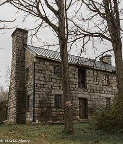 Abraham Byrd House |
June 21, 2007 (#07000572) |
2832 County Road 442 37°27′05″N 89°41′58″W |
Jackson | |
| 13 | Cape Girardeau Commercial Historic District | 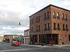 Cape Girardeau Commercial Historic District |
July 20, 2000 (#00000820) |
100 block of N. Main and the 100 block of Broadway Sts.; also 101 N. Main St.; also 127 N. Water St. 37°18′20″N 89°31′06″W |
Cape Girardeau | 101 N. Main and 127 N. Water represent boundary increases of July 11, 2007 and August 29, 2008 respectively |
| 14 | Cape Girardeau Court of Common Pleas | 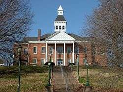 Cape Girardeau Court of Common Pleas |
October 25, 2010 (#10000856) |
44 N. Lorimier St. 37°18′18″N 89°31′12″W |
Cape Girardeau | |
| 15 | Central High School | 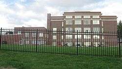 Central High School |
July 18, 2008 (#08000663) |
101 S. Pacific St. 37°18′12″N 89°31′50″W |
Cape Girardeau | |
| 16 | Dr. Jean Chapman House | 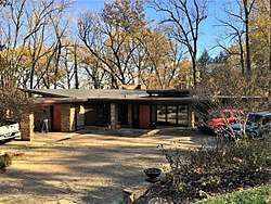 Dr. Jean Chapman House |
March 15, 2016 (#16000084) |
1150 N. Henderson Ave. 37°19′12″N 89°31′57″W |
Cape Girardeau | |
| 17 | George Boardman Clark House | 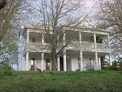 George Boardman Clark House |
July 22, 1994 (#94000738) |
6 S. Fountain St. 37°18′12″N 89°31′20″W |
Cape Girardeau | |
| 18 | Courthouse-Seminary Neighborhood Historic District | 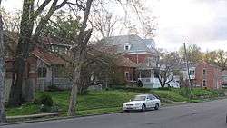 Courthouse-Seminary Neighborhood Historic District |
September 9, 2010 (#10000723) |
Roughly bounded by Middle St., Themis St., Main St., Aquamsi St., and Morgan Oaks St. 37°18′05″N 89°31′17″W |
Cape Girardeau | |
| 19 | Erlbacher Buildings | 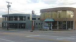 Erlbacher Buildings |
July 8, 2009 (#09000502) |
1105 and 1107 Broadway St. 37°18′30″N 89°31′56″W |
Cape Girardeau | |
| 20 | Esquire Theater | 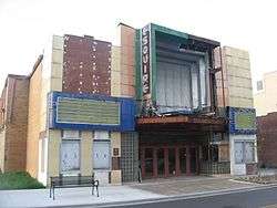 Esquire Theater |
September 15, 2005 (#05001025) |
824 Broadway St. 37°18′26″N 89°31′45″W |
Cape Girardeau | |
| 21 | Fort D | 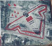 Fort D |
August 1, 2019 (#100004219) |
920 Fort St. 37°17′27″N 89°31′35″W |
Cape Girardeau | |
| 22 | Frizel-Welling House | 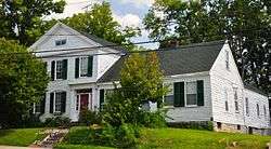 Frizel-Welling House |
June 25, 1999 (#99000742) |
209 W. Main St. 37°22′57″N 89°40′10″W |
Jackson | |
| 23 | Glenn House | 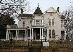 Glenn House |
October 11, 1979 (#79001354) |
325 S. Spanish St. 37°17′53″N 89°31′14″W |
Cape Girardeau | |
| 24 | Green's Ferry | June 21, 2007 (#07000571) |
On the Mississippi River at the end of Green's Ferry Rd.[5] 37°27′04″N 89°27′27″W |
Cape Girardeau | ||
| 25 | Haarig Commercial Historic District | 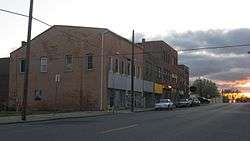 Haarig Commercial Historic District |
July 20, 2000 (#00000819) |
Along sections of the 600 block of Good Hope St. and 300 block of S. Sprigg St. 37°17′58″N 89°31′38″W |
Cape Girardeau | |
| 26 | Hanover Lutheran Church | 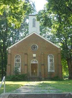 Hanover Lutheran Church |
September 14, 1987 (#87001575) |
2949 Perryville Rd. 37°21′10″N 89°33′37″W |
Cape Girardeau | |
| 27 | William Henry and Lilla Luce Harrison House | 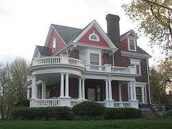 William Henry and Lilla Luce Harrison House |
December 6, 2005 (#05001375) |
313 Themis St. 37°18′17″N 89°31′17″W |
Cape Girardeau | |
| 28 | Himmelberger and Harrison Building | 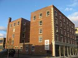 Himmelberger and Harrison Building |
July 17, 2003 (#03000653) |
400 Broadway St. 37°18′24″N 89°31′21″W |
Cape Girardeau | |
| 29 | House at 323 Themis Street | 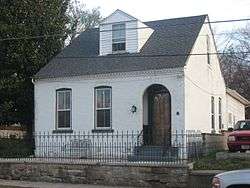 House at 323 Themis Street |
June 27, 1997 (#97000629) |
323 Themis St. 37°18′18″N 89°31′19″W |
Cape Girardeau | |
| 30 | Huhn-Harrison House | 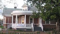 Huhn-Harrison House |
June 27, 2002 (#02000699) |
340 S. Lorimier St. 37°17′52″N 89°31′18″W |
Cape Girardeau | |
| 31 | Jackson Uptown Commercial Historic District | 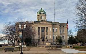 Jackson Uptown Commercial Historic District |
February 1, 2006 (#05001562) |
Roughly bounded by Court, Main, Missouri, and High Sts. 37°22′57″N 89°40′06″W |
Jackson | |
| 32 | Jefferson School | 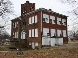 Jefferson School |
May 12, 2009 (#09000300) |
731 Jefferson Ave. 37°17′49″N 89°31′45″W |
Cape Girardeau | |
| 33 | Kage School | 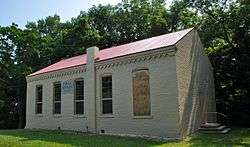 Kage School |
September 29, 2005 (#05001090) |
3110 Kage Rd. 37°19′57″N 89°34′45″W |
Cape Girardeau | |
| 34 | Klostermann Block | 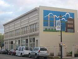 Klostermann Block |
July 22, 1994 (#94000739) |
7, 9, 11, 13, and 15 S. Spanish St. 37°18′11″N 89°31′11″W |
Cape Girardeau | |
| 35 | Edward S. and Mary Annatoile Albert Lilly House | 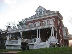 Edward S. and Mary Annatoile Albert Lilly House |
June 20, 2008 (#08000535) |
129 S. Lorimier St. 37°18′05″N 89°31′18″W |
Cape Girardeau | |
| 36 | Main-Spanish Commercial Historic District | 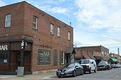 Main-Spanish Commercial Historic District |
December 30, 2008 (#08001259) |
Roughly the 100 blocks of Main and Spanish Sts. and adjacent portions of Themis and Independence Sts. 37°18′16″N 89°31′08″W |
Cape Girardeau | |
| 37 | Marquette Hotel | 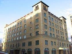 Marquette Hotel |
April 11, 2002 (#02000356) |
338 Broadway St. 37°18′24″N 89°31′19″W |
Cape Girardeau | |
| 38 | McKendree Chapel | 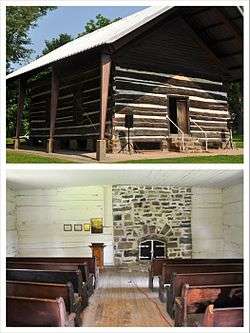 McKendree Chapel |
April 13, 1987 (#06000042) |
Off Interstate 55; also the southern side of Bainbridge Rd., 0.5 miles west of Interstate 55 37°22′41″N 89°37′07″W |
Jackson | Specific address represents a boundary increase of February 14, 2006 |
| 39 | Miller-Seabaugh House and Dr. Seabaugh Office Building | January 4, 1996 (#95001494) |
341 Market St. 37°25′58″N 89°47′52″W |
Millersville | ||
| 40 | Old Appleton Bridge | 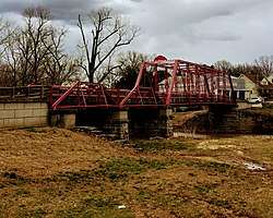 Old Appleton Bridge |
August 25, 2009 (#09000648) |
Main St. over Apple Creek 37°35′52″N 89°42′50″W |
Old Appleton | |
| 41 | Old Lorimier Cemetery | 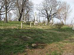 Old Lorimier Cemetery |
September 28, 2005 (#05001091) |
500 N. Fountain St. 37°18′40″N 89°31′12″W |
Cape Girardeau | |
| 42 | Oliver-Leming House | 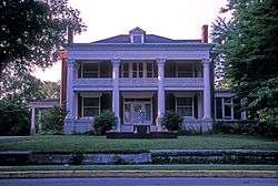 Oliver-Leming House |
September 12, 1980 (#80002323) |
740 North St. 37°18′35″N 89°31′40″W |
Cape Girardeau | |
| 43 | Abraham Russell Ponder House | 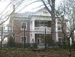 Abraham Russell Ponder House |
March 27, 2008 (#08000226) |
141 S. Louisiana Ave. 37°18′09″N 89°32′19″W |
Cape Girardeau | |
| 44 | Frederick W. and Mary Karau Pott House | 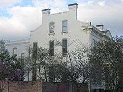 Frederick W. and Mary Karau Pott House |
June 25, 1999 (#99000745) |
826 Themis St. 37°18′22″N 89°31′46″W |
Cape Girardeau | |
| 45 | James Reynolds House | .jpg) James Reynolds House |
October 13, 1983 (#83003942) |
623 N. Main St. 37°18′41″N 89°31′05″W |
Cape Girardeau | |
| 46 | August and Amalia Shivelbine House | 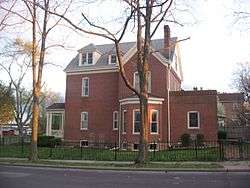 August and Amalia Shivelbine House |
June 25, 1999 (#99000743) |
303 S. Spanish St. 37°17′55″N 89°31′14″W |
Cape Girardeau | |
| 47 | South Middle Street Historic District |  South Middle Street Historic District |
October 14, 2009 (#09000829) |
513 William St. and 202-230 and 203-229 S. Middle St. 37°18′00″N 89°31′29″W |
Cape Girardeau | |
| 48 | Southeast Missourian Building |  Southeast Missourian Building |
June 1, 2005 (#05000509) |
301 Broadway St. 37°18′22″N 89°31′16″W |
Cape Girardeau | |
| 49 | St. James A.M.E. Church | 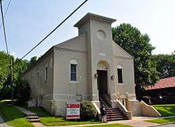 St. James A.M.E. Church |
January 15, 2014 (#13001085) |
516 North St. 37°18′34″N 89°31′26″W |
Cape Girardeau | |
| 50 | St. Vincent De Paul Catholic Church | 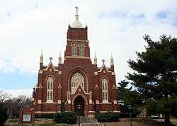 St. Vincent De Paul Catholic Church |
April 12, 1982 (#82003131) |
131 S. Main St. 37°18′03″N 89°31′10″W |
Cape Girardeau | |
| 51 | St. Vincent's College Building | 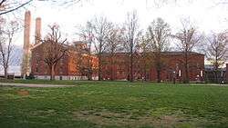 St. Vincent's College Building |
September 30, 2005 (#05001092) |
201 Morgan Oak St. 37°17′47″N 89°31′16″W |
Cape Girardeau | |
| 52 | Col George C. Thilenius House | 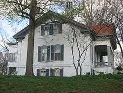 Col George C. Thilenius House |
April 14, 1983 (#83000974) |
100 Longview Pl. 37°18′24″N 89°32′30″W |
Cape Girardeau | |
| 53 | Trail of Tears State Park Archeological Site |  Trail of Tears State Park Archeological Site |
December 2, 1970 (#70000326) |
Address Restricted |
Oriole | An archeological site in Trail of Tears State Park |
| 54 | Julius Vasterling Building | 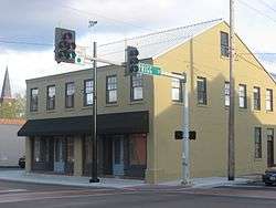 Julius Vasterling Building |
June 17, 2009 (#09000439) |
633-637 Broadway St. 37°18′23″N 89°31′35″W |
Cape Girardeau | |
| 55 | Warehouse Row Historic District | 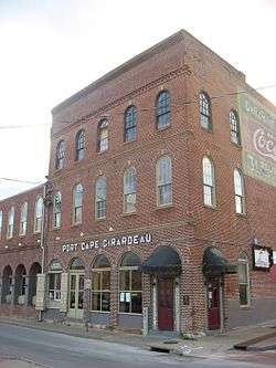 Warehouse Row Historic District |
December 4, 2004 (#04001285) |
19 N. Water St. 37°18′20″N 89°31′04″W |
Cape Girardeau | |
| 56 | Robert Felix and Elma Taylor Wichterich House | 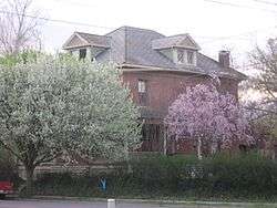 Robert Felix and Elma Taylor Wichterich House |
August 12, 1999 (#99000987) |
300 Good Hope St. 37°17′57″N 89°31′19″W |
Cape Girardeau | |
| 57 | J. Maple and Grace Senne Wilson House | 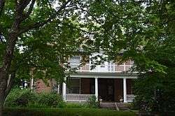 J. Maple and Grace Senne Wilson House |
July 7, 2015 (#15000365) |
344 N. Ellis St. 37°18′34″N 89°31′39″W |
Cape Girardeau | |
| 58 | Wood Building | 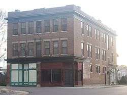 Wood Building |
December 10, 2003 (#03001269) |
1-3 S. Frederick and 605-607 Independence Sts. 37°18′14″N 89°31′33″W |
Cape Girardeau |
gollark: You could compete to answer vaguely HV-adjacent questions.
gollark: Why not have some sort of optional HV quiz event every month or something?
gollark: None are safe, as they say.
gollark: Oh no, it's *back*?
gollark: There is Matrix, but it's horrendously overcomplicated.
See also
References
| Wikimedia Commons has media related to National Register of Historic Places in Cape Girardeau County, Missouri. |
- The latitude and longitude information provided in this table was derived originally from the National Register Information System, which has been found to be fairly accurate for about 99% of listings. Some locations in this table may have been corrected to current GPS standards.
- "National Register of Historic Places: Weekly List Actions". National Park Service, United States Department of the Interior. Retrieved on August 14, 2020.
- Numbers represent an ordering by significant words. Various colorings, defined here, differentiate National Historic Landmarks and historic districts from other NRHP buildings, structures, sites or objects.
- The eight-digit number below each date is the number assigned to each location in the National Register Information System database, which can be viewed by clicking the number.
- Missouri Place Names, 1928-1945: Cape Girardeau County Archived 2008-12-03 at the Wayback Machine, Missouri Historical Society, n.d. Accessed 2013-03-22.
| Topics | |
|---|---|
| Lists by state |
|
| Lists by insular areas | |
| Lists by associated state | |
| Other areas | |
| Related | |
| |
Municipalities and communities of Cape Girardeau County, Missouri, United States | ||
|---|---|---|
| Cities | Map of Missouri highlighting Cape Girardeau County | |
| Villages | ||
| Townships | ||
| Unincorporated communities | ||
| Ghost towns | ||
| Footnotes | ‡This populated place also has portions in an adjacent county or counties | |
This article is issued from Wikipedia. The text is licensed under Creative Commons - Attribution - Sharealike. Additional terms may apply for the media files.