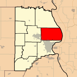
Randol Township, Cape Girardeau County, Missouri
Randol Township is one of ten townships in Cape Girardeau County, Missouri, USA. As of the 2000 census, its population was 4,030.
Randol Township | |
|---|---|
 | |
| Coordinates: 37°23′17″N 089°32′45″W | |
| Country | United States |
| State | Missouri |
| County | Cape Girardeau |
| Area | |
| • Total | 66.92 sq mi (173.31 km2) |
| • Land | 65.3 sq mi (169.11 km2) |
| • Water | 1.62 sq mi (4.2 km2) 2.42% |
| Elevation | 650 ft (198 m) |
| Population (2000) | |
| • Total | 4,030 |
| • Density | 61.7/sq mi (23.8/km2) |
| FIPS code | 29-60572[2] |
| GNIS feature ID | 0766401 |
History
Randol Township was founded in 1872.[3] The township derives its name from Enos Randal, a pioneer citizen.[4]
Geography
Randol Township covers an area of 66.92 square miles (173.3 km2) and contains no incorporated settlements. It contains two unincorporated settlements: Oriole, and Egypt Mills; and ten cemeteries: Ervin, Heuer, Iona, Lange, McKendree, Minton, Noland, Thompson, Vangilder and Zierath.
The streams of Juden Creek, Bainbridge Creek, Little Flora Creek and Soakie Creek run through this township.
gollark: <@111608748027445248> What does the AES thing return? A table? A string?
gollark: <@301092081827577866> It should support AES transmitted over it fine...
gollark: It's probably automatic.
gollark: Ah, some idiot is sending spammy pings again.
gollark: It has been done.
References
- "US Board on Geographic Names". United States Geological Survey. 2007-10-25. Retrieved 2008-01-31.
- "U.S. Census website". United States Census Bureau. Retrieved 2008-01-31.
- History of Southeast Missouri: A Narrative Account of Its Historical Progress, Its People and Its Principal Interests, Volume 1. Lewis Publishing Company. 1912. p. 163.
- "Cape Girardeau County Place Names, 1928–1945 (archived)". The State Historical Society of Missouri. Archived from the original on 24 June 2016. Retrieved 10 September 2016.CS1 maint: BOT: original-url status unknown (link)
External links
Municipalities and communities of Cape Girardeau County, Missouri, United States | ||
|---|---|---|
| Cities | 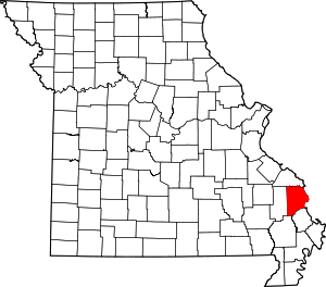 Map of Missouri highlighting Cape Girardeau County | |
| Villages | ||
| Townships | ||
| Unincorporated communities | ||
| Ghost towns | ||
| Footnotes | ‡This populated place also has portions in an adjacent county or counties | |
This article is issued from Wikipedia. The text is licensed under Creative Commons - Attribution - Sharealike. Additional terms may apply for the media files.