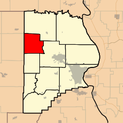
Whitewater Township, Cape Girardeau County, Missouri
Whitewater Township is one of ten townships in Cape Girardeau County, Missouri, USA. As of the 2000 census, its population was 1,263.
Whitewater Township | |
|---|---|
 | |
| Coordinates: 37°27′10″N 089°48′16″W | |
| Country | United States |
| State | Missouri |
| County | Cape Girardeau |
| Area | |
| • Total | 36.5 sq mi (94.54 km2) |
| • Land | 36.45 sq mi (94.41 km2) |
| • Water | 0.05 sq mi (0.13 km2) 0.14% |
| Elevation | 443 ft (135 m) |
| Population (2000) | |
| • Total | 1,263 |
| • Density | 34.7/sq mi (13.4/km2) |
| FIPS code | 29-79630[2] |
| GNIS feature ID | 0766404 |
History
Whitewater Township was founded in 1852.[3] The township took its name from the Whitewater River.[4]
Geography
Whitewater Township covers an area of 36.5 square miles (95 km2) and contains no incorporated settlements. It contains thirteen cemeteries: Baker, Estes, Gladish, Kurre, Mayfield, Miller, Old Caney Fork, Old Niswonger, Riehn, Schmidt, Snyder, Wilkinson and Wise.
The streams of Caney Fork, Crawford Creek, Dry Creek, Little Muddy Creek, Panther Creek, Sandy Branch and Wolf Creek run through this township.
gollark: I guess if you could hibernate somehow...
gollark: Sadly, humans just don't have the surface area.
gollark: And you are less likely to be infected there if you have fewer people going out for nonessential reasons.
gollark: It's not a risk you can choose.
gollark: You need to leave home a bit to get food and stuff. It's not a risk you *choose* if someone infects you there because they didn't want to stay at home.
References
- "US Board on Geographic Names". United States Geological Survey. 2007-10-25. Retrieved 2008-01-31.
- "U.S. Census website". United States Census Bureau. Retrieved 2008-01-31.
- History of Southeast Missouri: A Narrative Account of Its Historical Progress, Its People and Its Principal Interests, Volume 1. Lewis Publishing Company. 1912. p. 163.
- "Cape Girardeau County Place Names, 1928–1945 (archived)". The State Historical Society of Missouri. Archived from the original on 24 June 2016. Retrieved 10 September 2016.
External links
Municipalities and communities of Cape Girardeau County, Missouri, United States | ||
|---|---|---|
| Cities | 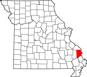 Map of Missouri highlighting Cape Girardeau County | |
| Villages | ||
| Townships | ||
| Unincorporated communities | ||
| Ghost towns | ||
| Footnotes | ‡This populated place also has portions in an adjacent county or counties | |
This article is issued from Wikipedia. The text is licensed under Creative Commons - Attribution - Sharealike. Additional terms may apply for the media files.