National Register of Historic Places listings in Lafayette County, Missouri
This is a list of the National Register of Historic Places listings in Lafayette County, Missouri.
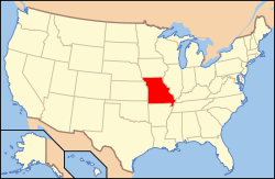
Location of Lafayette County in Missouri
This is intended to be a complete list of the properties and districts on the National Register of Historic Places in Lafayette County, Missouri, United States. Latitude and longitude coordinates are provided for many National Register properties and districts; these locations may be seen together in a map.[1]
There are 29 properties and districts listed on the National Register in the county.
- This National Park Service list is complete through NPS recent listings posted August 14, 2020.[2]
Current listings
| [3] | Name on the Register | Image | Date listed[4] | Location | City or town | Description |
|---|---|---|---|---|---|---|
| 1 | Anderson House and Lexington Battlefield | 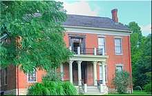 Anderson House and Lexington Battlefield |
June 4, 1969 (#69000110) |
Roughly bounded by 10th, 15th, Utah and Wood Sts., and Missouri Pacific RR 39°11′34″N 93°52′46″W |
Lexington | |
| 2 | Napoleon Buck House | November 14, 1997 (#97001431) |
0.40 mi. S of jct. of US 24 and MO 273 39°11′49″N 93°32′09″W |
Waverly | No longer in existence | |
| 3 | Minatree Catron House | November 14, 1997 (#97001432) |
0.1 mi W of jct. of US 24 and MO 110 39°10′49″N 93°47′55″W |
Lexington | ||
| 4 | John E. Cheatham House | July 8, 1993 (#93000550) |
739 MO 13 39°10′21″N 93°52′45″W |
Lexington | ||
| 5 | Chicago and Alton Railroad Depot at Higginsville | March 25, 1987 (#87000451) |
2109 Main St. 39°04′25″N 93°43′00″W |
Higginsville | ||
| 6 | Commercial Community Historic District | August 4, 1983 (#83001025) |
Roughly bounded by 8th, 13th, South, Broadway, and Main Sts. 39°11′09″N 93°52′52″W |
Lexington | ||
| 7 | Confederate Chapel, Cemetery and Cottage | December 16, 1981 (#81000335) |
N of Higginsville 39°05′54″N 93°43′45″W |
Higginsville | ||
| 8 | Cumberland Presbyterian Church | 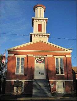 Cumberland Presbyterian Church |
November 14, 1978 (#78001665) |
112 S. 13th St. 39°11′06″N 93°52′45″W |
Lexington | |
| 9 | James M. Dinwiddie House | November 14, 1997 (#97001430) |
0.25 mi. E of jct. of US 24 and MO 184 39°11′32″N 93°42′06″W |
Dover | ||
| 10 | Theodore Gosewisch House | 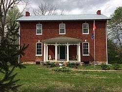 Theodore Gosewisch House |
November 14, 1997 (#97001433) |
0.5 mi. W of jct. of MO 13 and Marshall School Rd. 39°09′28″N 93°53′30″W |
Lexington | |
| 11 | Alexander and Elizabeth Aull Graves House | July 8, 1993 (#93000552) |
2326 Aull Ln. 39°10′32″N 93°51′56″W |
Lexington | No longer in existence | |
| 12 | Hicklin Hearthstone | December 28, 1982 (#82000585) |
E of Lexington on US 24 39°11′10″N 93°49′44″W |
Lexington | ||
| 13 | Hicklin School | February 24, 2004 (#04000088) |
MO 24 39°11′05″N 93°49′29″W |
Lexington | ||
| 14 | Highland Avenue Historic District | 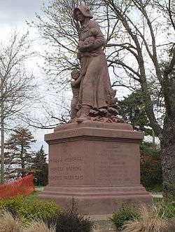 Highland Avenue Historic District |
August 4, 1983 (#83001026) |
Roughly bounded by Highland Ave. from Rock to Bluff Sts. 39°11′04″N 93°52′30″W |
Lexington | |
| 15 | House at 1413 Lafayette St. | March 25, 1999 (#99000379) |
1413 Lafayette St. 39°11′13″N 93°52′39″W |
Lexington | ||
| 16 | Houx-Hoefer-Rehkop House | March 29, 1983 (#83001027) |
1900 Walnut St. 39°04′33″N 93°43′07″W |
Higginsville | ||
| 17 | David John House | July 8, 1993 (#93000553) |
103 S. 23rd St. 39°11′06″N 93°51′23″W |
Lexington | No longer in existence | |
| 18 | George Johnson House | July 8, 1993 (#93000554) |
102 S. 30th St. 39°11′07″N 93°51′16″W |
Lexington | ||
| 19 | Lafayette County Courthouse |  Lafayette County Courthouse |
September 22, 1970 (#70000339) |
Public Sq. 39°11′06″N 93°52′49″W |
Lexington | |
| 20 | Linwood Lawn | April 23, 1973 (#73001044) |
SE of Lexington off U.S. 24 39°09′55″N 93°50′54″W |
Lexington | ||
| 21 | Odessa Ice Cream Company Building | 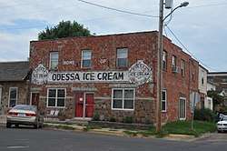 Odessa Ice Cream Company Building |
October 3, 1996 (#96001065) |
101 W. Dryden St. 38°59′36″N 93°57′15″W |
Odessa | |
| 22 | Old Neighborhoods Historic District | _Manor.JPG) Old Neighborhoods Historic District |
August 4, 1983 (#83001028) |
Roughly bounded by 13th, 22nd, South Sts., Forest and Washington Aves. 39°11′08″N 93°52′28″W |
Lexington | |
| 23 | William P. Robinson House | November 14, 1997 (#97001428) |
).2 mi. E and 0.15 mi. S of jct. of MO 107 and MO 112 39°09′41″N 93°50′24″W |
Lexington | ||
| 24 | Thomas Shelby House | November 14, 1997 (#97001429) |
0.25 mi. E of US 24 and MO 111 39°10′47″N 93°47′09″W |
Lexington | Demolished(?) | |
| 25 | Spratt-Allen-Aull House | July 8, 1993 (#93000555) |
2321 Aull Ln. 39°10′30″N 93°51′57″W |
Lexington | ||
| 26 | Thomas Talbot and Rebecca Walton Smithers Stramcke House | September 29, 1999 (#99001208) |
15834 Highway O 39°08′24″N 93°52′57″W |
Lexington | ||
| 27 | D. W. B. and Julia Waddell Tevis House | July 8, 1993 (#93000556) |
505 S. 13th St. 39°10′43″N 93°52′43″W |
Lexington | ||
| 28 | Waddell House |  Waddell House |
October 11, 1979 (#79001378) |
1704 South St. 39°11′02″N 93°52′29″W |
Lexington | |
| 29 | Wentworth Military Academy |  Wentworth Military Academy |
November 24, 1980 (#80002373) |
Washington Ave. and 18th St. 39°11′14″N 93°52′22″W |
Lexington |
gollark: ... hmm, in that case, maybe something *contrasting* with the teal (and with a different offfsite use policy) would be better.
gollark: Also, I'd prefer if the *background* were teal and the text white or something - see the actual site.
gollark: Eeeh. The chrono there kind of makes the writing annoying to read.
gollark: Well, in that case, we shall need to either delay the logos until birdz can be reached (if they agree, obviously) or take out the chrono.
gollark: I don't think it could ever actually work.
See also
References
| Wikimedia Commons has media related to National Register of Historic Places in Lafayette County, Missouri. |
- The latitude and longitude information provided in this table was derived originally from the National Register Information System, which has been found to be fairly accurate for about 99% of listings. Some locations in this table may have been corrected to current GPS standards.
- "National Register of Historic Places: Weekly List Actions". National Park Service, United States Department of the Interior. Retrieved on August 14, 2020.
- Numbers represent an ordering by significant words. Various colorings, defined here, differentiate National Historic Landmarks and historic districts from other NRHP buildings, structures, sites or objects.
- The eight-digit number below each date is the number assigned to each location in the National Register Information System database, which can be viewed by clicking the number.
| Topics | |
|---|---|
| Lists by state |
|
| Lists by insular areas | |
| Lists by associated state | |
| Other areas | |
| Related | |
| |
Municipalities and communities of Lafayette County, Missouri, United States | ||
|---|---|---|
| Cities | Map of Missouri highlighting Lafayette County | |
| Villages | ||
| Townships | ||
| Unincorporated communities | ||
| Ghost towns | ||
| Footnotes | ‡This populated place also has portions in an adjacent county or counties | |
This article is issued from Wikipedia. The text is licensed under Creative Commons - Attribution - Sharealike. Additional terms may apply for the media files.