National Register of Historic Places listings in Carroll County, Missouri
This is a list of the National Register of Historic Places listings in Carroll County, Missouri.
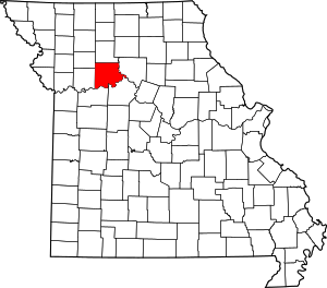
Location of Carroll County in Missouri
This is intended to be a complete list of the properties and districts on the National Register of Historic Places in Carroll County, Missouri, United States. Latitude and longitude coordinates are provided for many National Register properties and districts; these locations may be seen together in a map.[1]
There are 6 properties and districts listed on the National Register in the county.
- This National Park Service list is complete through NPS recent listings posted August 14, 2020.[2]
Current listings
| [3] | Name on the Register | Image | Date listed[4] | Location | City or town | Description |
|---|---|---|---|---|---|---|
| 1 | Carroll County Court House | 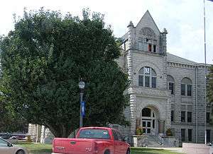 Carroll County Court House |
July 21, 1995 (#95000858) |
Courthouse Sq. 39°21′29″N 93°29′47″W |
Carrollton | |
| 2 | Carroll County Sheriff's Quarters and Jail |  Carroll County Sheriff's Quarters and Jail |
October 11, 1979 (#79001355) |
101 W. Washington St. 39°21′27″N 93°29′48″W |
Carrollton | |
| 3 | Farmers Bank Building | 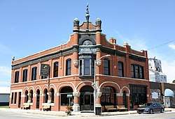 Farmers Bank Building |
July 7, 1994 (#94000702) |
114 S. Pine St. 39°18′10″N 93°40′36″W |
Norborne | |
| 4 | U.S. Post Office | 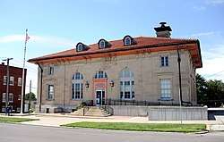 U.S. Post Office |
May 12, 1977 (#77001570) |
101 N. Folger St. 39°21′22″N 93°29′31″W |
Carrollton | |
| 5 | Wilcoxson and Company Bank |  Wilcoxson and Company Bank |
January 21, 1983 (#83000975) |
1 W. Washington Ave. 39°21′28″N 93°29′45″W |
Carrollton | |
| 6 | Wright II Archeological Site | May 27, 1971 (#71000464) |
Address Restricted |
Miami Station |
gollark: Hypothetically, since it's *not* like I did that.
gollark: If I did things with it you are more likely to detect it.
gollark: Why censor the hostname of your VPS anyway? It's not like I used it and an unknown vulnerability in the OVH management system to gain access and install potatOS on it.
gollark: It was just some people waving woggles around.
gollark: I assume it's one of those anomalous VPSes which literally cannot be halted.
See also
References
- The latitude and longitude information provided in this table was derived originally from the National Register Information System, which has been found to be fairly accurate for about 99% of listings. Some locations in this table may have been corrected to current GPS standards.
- "National Register of Historic Places: Weekly List Actions". National Park Service, United States Department of the Interior. Retrieved on August 14, 2020.
- Numbers represent an ordering by significant words. Various colorings, defined here, differentiate National Historic Landmarks and historic districts from other NRHP buildings, structures, sites or objects.
- The eight-digit number below each date is the number assigned to each location in the National Register Information System database, which can be viewed by clicking the number.
| Topics | |
|---|---|
| Lists by state |
|
| Lists by insular areas | |
| Lists by associated state | |
| Other areas | |
| Related | |
| |
Municipalities and communities of Carroll County, Missouri, United States | ||
|---|---|---|
| Cities | Map of Missouri highlighting Carroll County | |
| Village | ||
| Townships | ||
| Unincorporated communities | ||
| Ghost towns | ||
| Footnotes | ‡This populated place also has portions in an adjacent county or counties | |
This article is issued from Wikipedia. The text is licensed under Creative Commons - Attribution - Sharealike. Additional terms may apply for the media files.