National Register of Historic Places listings in Adair County, Missouri
This is a list of the National Register of Historic Places listings in Adair County, Missouri.
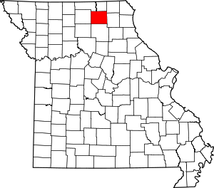
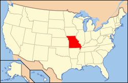
Location of Adair County in Missouri
This is intended to be a complete list of the properties and districts on the National Register of Historic Places in Adair County, Missouri, United States. Latitude and longitude coordinates are provided for many National Register properties and districts; these locations may be seen together in a map.[1]
There are 20 properties and districts listed on the National Register in the county.
- This National Park Service list is complete through NPS recent listings posted August 14, 2020.[2]
Current listings
| [3] | Name on the Register | Image | Date listed[4] | Location | City or town | Description |
|---|---|---|---|---|---|---|
| 1 | Adair County Courthouse | 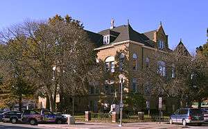 Adair County Courthouse |
August 11, 1978 (#78001636) |
Washington St. 40°11′42″N 92°35′01″W |
Kirksville | |
| 2 | Bear Creek Baptist Church | 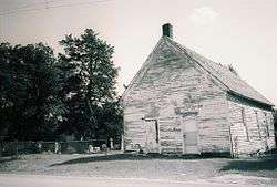 Bear Creek Baptist Church |
March 29, 1984 (#84002132) |
N of Kirksville off US 63 40°14′30″N 92°37′31″W |
Kirksville | |
| 3 | Cabins Historic District | 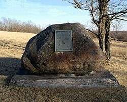 Cabins Historic District |
July 17, 1979 (#79001344) |
S of Novinger off MO 6 40°12′31″N 92°41′10″W |
Novinger | |
| 4 | Dockery Hotel | February 10, 1983 (#83000971) |
Elson and McPherson Sts. 40°11′38″N 92°35′04″W |
Kirksville | Demolished in 1991.[5] | |
| 5 | First Presbyterian Church | July 10, 2017 (#100001298) |
201 S. High St. 40°11′38″N 92°34′51″W |
Kirksville | ||
| 6 | Grim Building |  Grim Building |
June 27, 1979 (#79001343) |
113-115 E. Washington St. 40°11′43″N 92°34′52″W |
Kirksville | |
| 7 | Capt. Thomas C. Harris House | 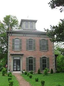 Capt. Thomas C. Harris House |
October 15, 1973 (#73001034) |
1308 N. Franklin St. 40°12′19″N 92°34′56″W |
Kirksville | |
| 8 | Journal Printing Company Building | 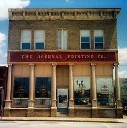 Journal Printing Company Building |
July 14, 2011 (#11000439) |
119 S. Elson St. 40°11′40″N 92°35′03″W |
Kirksville | |
| 9 | Kirksville Courthouse Square Historic District |  Kirksville Courthouse Square Historic District |
May 21, 2009 (#09000330) |
200 block N. Franklin St., 100 block E. Harrison St., 100 block W. Harrison St. 40°11′44″N 92°34′59″W |
Kirksville | |
| 10 | Drs. George and Blanche Laughlin House | Drs. George and Blanche Laughlin House |
March 11, 2014 (#14000047) |
706 S. Halliburton St. 40°11′22″N 92°34′37″W |
Kirksville | |
| 11 | Lincoln School | January 31, 2017 (#100000606) |
907 S. Wabash St. 40°11′17″N 92°35′17″W |
Kirksville | ||
| 12 | Masonic Temple | 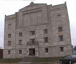 Masonic Temple |
January 7, 2010 (#09001208) |
217 E. Harrison St. 40°11′44″N 92°34′55″W |
Kirksville | Egyptian Revival architecture[6] |
| 13 | St. Mary's Church | 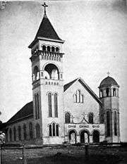 St. Mary's Church |
December 16, 1974 (#74001069) |
On MO 11 40°15′08″N 92°22′27″W |
Adair | Romanesque Revival architecture. |
| 14 | Salisbury School | October 23, 2017 (#100001757) |
Missouri Route K 40°08′48″N 92°41′50″W |
Kirksville | ||
| 15 | Dr. E. Sanborn Smith House | 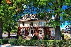 Dr. E. Sanborn Smith House |
January 30, 2009 (#08001385) |
111 E. Patterson St. 40°11′11″N 92°34′59″W |
Kirksville | |
| 16 | Orie J. Smith Black and White Stock Farm Historic District | 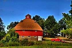 Orie J. Smith Black and White Stock Farm Historic District |
January 16, 2001 (#00001658) |
0.5 miles SE of Jct. of MO P and Co. Rd. 129B 40°13′32″N 92°33′33″W |
Kirksville | |
| 17 | Sojourners Club | March 11, 2014 (#14000048) |
211 S. Elson St. 40°11′36″N 92°35′03″W |
Kirksville | ||
| 18 | Thousand Hills State Park Petroglyphs Archeological Site | 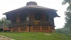 Thousand Hills State Park Petroglyphs Archeological Site |
January 23, 1970 (#70000320) |
W of Kirksville 40°11′12″N 92°38′28″W |
Kirksville | Within Thousand Hills State Park |
| 19 | Travelers Hotel | 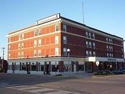 Travelers Hotel |
September 16, 2009 (#09000718) |
301 W. Washington St. 40°11′41″N 92°35′07″W |
Kirksville | |
| 20 | Trinity Episcopal Church | 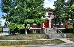 Trinity Episcopal Church |
January 2, 2008 (#07001338) |
124 N Mulanix St. 40°11′50″N 92°34′47″W |
Kirksville |
gollark: What, so they'll just be magic powerboxes?
gollark: Why would you *cool* a pebble bed reactor with *liquid helium*?
gollark: Pebble bed reactors?
gollark: Wait, what's your idea?
gollark: I'll report it to the Minecraft Physics Committee.
See also
References
| Wikimedia Commons has media related to National Register of Historic Places in Adair County, Missouri. |
- The latitude and longitude information provided in this table was derived originally from the National Register Information System, which has been found to be fairly accurate for about 99% of listings. Some locations in this table may have been corrected to current GPS standards.
- "National Register of Historic Places: Weekly List Actions". National Park Service, United States Department of the Interior. Retrieved on August 14, 2020.
- Numbers represent an ordering by significant words. Various colorings, defined here, differentiate National Historic Landmarks and historic districts from other NRHP buildings, structures, sites or objects.
- The eight-digit number below each date is the number assigned to each location in the National Register Information System database, which can be viewed by clicking the number.
- "Archived copy". Archived from the original on 2015-07-13. Retrieved 2015-01-17.CS1 maint: archived copy as title (link)
- Eden Derby, Historic Places: Inside the Masonic Temple, KTVO TV-3, May 13, 2010
| Topics | |
|---|---|
| Lists by state |
|
| Lists by insular areas | |
| Lists by associated state | |
| Other areas | |
| Related | |
| |
Municipalities and communities of Adair County, Missouri, United States | ||
|---|---|---|
| Cities | Map of Missouri highlighting Adair County | |
| Villages | ||
| Townships | ||
| Unincorporated communities | ||
| Ghost towns | ||
| Footnotes | ‡This populated place also has portions in an adjacent county or counties | |
This article is issued from Wikipedia. The text is licensed under Creative Commons - Attribution - Sharealike. Additional terms may apply for the media files.