National Register of Historic Places listings in Broward County, Florida
This is a list of the National Register of Historic Places listings in Broward County, Florida.

Location of Broward County in Florida
This is intended to be a complete list of the properties and districts on the National Register of Historic Places in Broward County, Florida, United States. The locations of National Register properties and districts for which the latitude and longitude coordinates are included below, may be seen in a map.[1]
There are 39 properties and districts listed on the National Register in the county. Another property was once listed but has been removed.
- This National Park Service list is complete through NPS recent listings posted August 14, 2020.[2]
| Alachua - Baker - Bay - Bradford - Brevard - Broward - Calhoun - Charlotte - Citrus - Clay - Collier - Columbia - DeSoto - Dixie - Duval - Escambia - Flagler - Franklin - Gadsden - Gilchrist - Glades - Gulf - Hamilton - Hardee - Hendry - Hernando - Highlands - Hillsborough (Tampa) - Holmes - Indian River - Jackson - Jefferson - Lafayette - Lake - Lee - Leon - Levy - Liberty - Madison - Manatee - Marion - Martin - Miami-Dade (Miami) - Monroe - Nassau - Okaloosa - Okeechobee - Orange - Osceola - Palm Beach - Pasco - Pinellas - Polk - Putnam - St. Johns - St. Lucie - Santa Rosa - Sarasota - Seminole - Sumter - Suwannee - Taylor - Union - Volusia - Wakulla - Walton - Washington |
Current listings
| [3] | Name on the Register[4] | Image | Date listed[5] | Location | City or town | Description |
|---|---|---|---|---|---|---|
| 1 | Bonnet House | 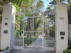 Bonnet House |
July 5, 1984 (#84000832) |
900 Birch Road 26°08′07″N 80°06′20″W |
Fort Lauderdale | A winter retreat built in 1920 by Frederic Clay Bartlett. [6] |
| 2 | Bryan Building | 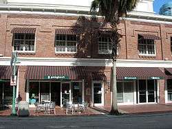 Bryan Building |
October 30, 1997 (#97001282) |
220-230 Brickell Avenue 26°07′08″N 80°08′40″W |
Fort Lauderdale | One of the first hotels in Fort Lauderdale's original downtown district, and one of the first commercial buildings built after a 1912 fire in the city. Housed the law office of Ennis Shepherd, a city judge and attorney, from 1947 until the 1990s.[7] |
| 3 | James D. and Alice Butler House | 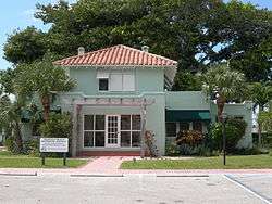 James D. and Alice Butler House |
July 28, 1995 (#95000916) |
380 East Hillsboro Boulevard 26°19′04″N 80°05′56″W |
Deerfield Beach | |
| 4 | Cap's Place | 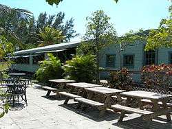 Cap's Place |
August 10, 1990 (#90001227) |
2980 Northeast 31st Avenue 26°16′05″N 80°04′55″W |
Lighthouse Point | |
| 5 | Council Oak Tree Site on the Hollywood Seminole Indian Reservation | 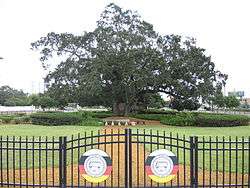 Council Oak Tree Site on the Hollywood Seminole Indian Reservation |
December 4, 2012 (#12000992) |
intersection between U.S. 441 (State Road 7) and Stirling Rd 26°02′44″N 80°12′35″W |
Hollywood | |
| 6 | Croissant Park Administration Building | 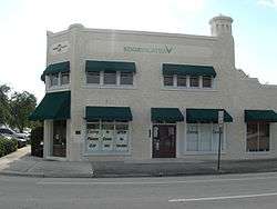 Croissant Park Administration Building |
July 25, 2001 (#01000761) |
1421 South Andrews Avenue 26°06′11″N 80°08′36″W |
Fort Lauderdale | |
| 7 | Davie School |  Davie School |
March 29, 1988 (#88000223) |
6650 Griffin Road 26°03′50″N 80°14′09″W |
Davie | |
| 8 | Davie Woman's Club | .jpg) Davie Woman's Club |
May 16, 2016 (#16000267) |
6551 SW. 45th St. 26°03′57″N 80°14′04″W |
Davie | |
| 9 | Deerfield Beach Elementary School | 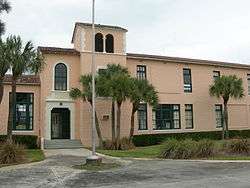 Deerfield Beach Elementary School |
April 16, 1990 (#90000319) |
651 Northeast 1st Street 26°19′10″N 80°05′45″W |
Deerfield Beach | |
| 10 | Fort Lauderdale Woman's Club | 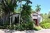 Fort Lauderdale Woman's Club |
February 4, 2019 (#100003404) |
20 S. Andrews Ave. 26°07′18″N 80°08′36″W |
Fort Lauderdale | |
| 11 | Sam Gilliam House | 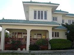 Sam Gilliam House |
March 29, 2001 (#01000289) |
11 Southwest 15th Street 26°06′12″N 80°08′51″W |
Fort Lauderdale | |
| 12 | Hammerstein House |  Hammerstein House |
February 15, 2005 (#05000051) |
1520 Polk Street 26°00′53″N 80°08′16″W |
Hollywood | |
| 13 | Hillsboro Inlet Light Station | 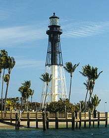 Hillsboro Inlet Light Station |
February 16, 1979 (#79000661) |
Off Interstate 95 at Hillsboro Inlet 26°15′32″N 80°04′51″W |
Pompano Beach | Completed in 1907, the lighthouse stands 142 feet tall (43.3 meters) and is one of the most powerful lighthouses in the world whose light can be seen at 28 nautical miles.[8] |
| 14 | Hollywood Boulevard Historic Business District | 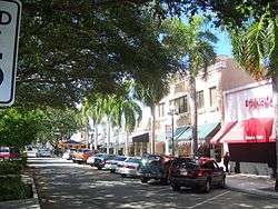 Hollywood Boulevard Historic Business District |
February 18, 1999 (#99000231) |
Along Hollywood Boulevard, between 21st Avenue and Young Circle 26°00′41″N 80°08′43″W |
Hollywood | |
| 15 | Hollywood Garden Club | 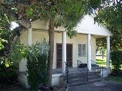 Hollywood Garden Club |
February 15, 2005 (#05000052) |
2940 Hollywood Boulevard 26°00′43″N 80°10′06″W |
Hollywood | |
| 16 | Hollywood Woman's Club | 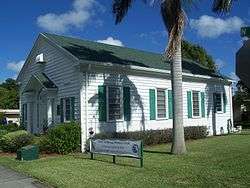 Hollywood Woman's Club |
February 10, 1995 (#95000055) |
501 North 14th Avenue 26°00′55″N 80°08′03″W |
Hollywood | |
| 17 | Dr. Willard Van Orsdel King House | 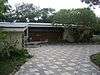 Dr. Willard Van Orsdel King House |
February 21, 2006 (#06000059) |
1336 Seabreeze Boulevard 26°06′18″N 80°06′31″W |
Fort Lauderdale | |
| 18 | Link Trainer Building | 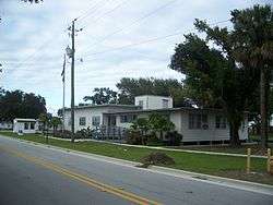 Link Trainer Building |
May 20, 1998 (#98000454) |
4050 Southwest 14th Avenue 26°04′16″N 80°09′34″W |
Fort Lauderdale | The only remaining build of the original Fort Lauderdale Naval Air Station, it housed 6 link trainers to train World War II Pilots.[9] |
| 19 | Lock No. 1, North New River Canal | 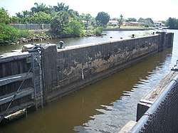 Lock No. 1, North New River Canal |
February 17, 1978 (#78000932) |
South of Plantation on State Road 84 26°05′39″N 80°13′46″W |
Plantation | |
| 20 | Mai-Kai Restaurant |  Mai-Kai Restaurant |
November 18, 2014 (#14000951) |
3599 N. Federal Hwy. 26°10′21″N 80°07′12″W |
Oakland Park | |
| 21 | New River Inn | 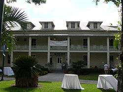 New River Inn |
June 19, 1972 (#72000303) |
229 Southwest 2nd Avenue 26°07′09″N 80°08′51″W |
Fort Lauderdale | |
| 22 | North Woodlawn Cemetery | 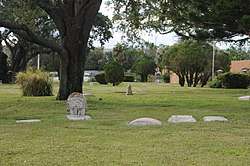 North Woodlawn Cemetery |
November 29, 2017 (#100001861) |
1936 NW 9th St. 26°08′06″N 80°10′05″W |
Fort Lauderdale | |
| 23 | Nyberg-Swanson House | 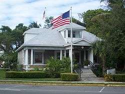 Nyberg-Swanson House |
May 28, 1999 (#99000583) |
102 West Dania Beach Boulevard 26°03′08″N 80°08′42″W |
Dania Beach | |
| 24 | Oakland Park Elementary School | 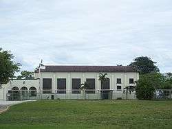 Oakland Park Elementary School |
June 9, 1988 (#88000714) |
936 Northeast Thirty-third Street 26°10′04″N 80°08′07″W |
Oakland Park | |
| 25 | Old Deerfield School | 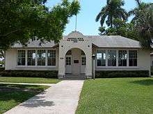 Old Deerfield School |
May 5, 1999 (#99000525) |
232 Northeast Second Street 26°19′12″N 80°05′59″W |
Deerfield Beach | |
| 26 | Old Dillard High School | 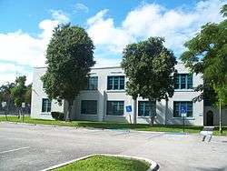 Old Dillard High School |
February 20, 1991 (#91000107) |
1001 Northwest Fourth Street 26°07′31″N 80°09′19″W |
Fort Lauderdale | |
| 27 | Old Seaboard Air Line Railway Station |  Old Seaboard Air Line Railway Station |
April 5, 1990 (#90000597) |
1300 West Hillsboro Boulevard 26°19′02″N 80°07′22″W |
Deerfield Beach | |
| 28 | Pompano Beach Mound |  Pompano Beach Mound |
April 17, 2014 (#14000151) |
1232 SE. 13th St. 26°13′18″N 80°05′33″W |
Pompano Beach | |
| 29 | St. Anthony School |  St. Anthony School |
September 26, 1997 (#97001171) |
820 Northeast 3rd Street 26°07′28″N 80°08′06″W |
Fort Lauderdale | |
| 30 | Sample Estate | 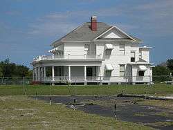 Sample Estate |
March 1, 1984 (#84000834) |
3161 North Dixie Highway 26°16′11″N 80°06′57″W |
Pompano Beach | House on the estate, known as the Sample-McDougald House, moved to new site[10] |
| 31 | Sample-McDougald House | Sample-McDougald House |
September 15, 2004 (#04000970) |
450 Northeast 10th Street 26°14′24″N 80°07′11″W |
Pompano Beach | |
| 32 | South Side School | 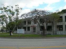 South Side School |
July 19, 2006 (#06000617) |
701 South Andrews Avenue 26°05′46″N 80°08′38″W |
Fort Lauderdale | |
| 33 | SS COPENHAGEN (shipwreck) | SS COPENHAGEN (shipwreck) |
May 31, 2001 (#01000532) |
Lauderdale-By-The-Sea Dropoff reef south of Hillsboro Inlet 26°12′21″N 80°05′07″W |
Lauderdale-By-The-Sea | |
| 34 | Stranahan House | 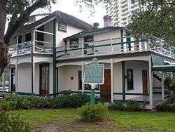 Stranahan House |
October 2, 1973 (#73000569) |
335 Southeast 6th Avenue 26°07′05″N 80°08′17″W |
Fort Lauderdale | |
| 35 | Alfred and Olive Thorpe Lustron House | 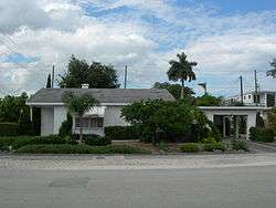 Alfred and Olive Thorpe Lustron House |
November 1, 2007 (#07001114) |
1001 Northeast 2nd Street 26°07′34″N 80°07′59″W |
Fort Lauderdale | A prefabricated Lustron house |
| 36 | Villa Providence | 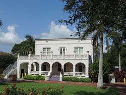 Villa Providence |
December 24, 2013 (#13000962) |
324 SW. 2nd Ave. 25°58′52″N 80°09′02″W |
Hallandale Beach | |
| 37 | Old West Side Grade School | 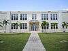 Old West Side Grade School |
September 19, 2012 (#12000790) |
301 Harmon Avenue 26°07′07″N 80°09′32″W |
Fort Lauderdale | |
| 38 | Williams House | 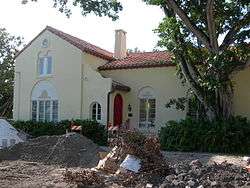 Williams House |
September 28, 2005 (#05001089) |
119 Rose Drive 26°06′37″N 80°08′30″W |
Fort Lauderdale | |
| 39 | Joseph Wesley Young House | 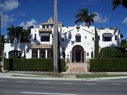 Joseph Wesley Young House |
August 10, 1989 (#89001076) |
1055 Hollywood Boulevard 26°00′48″N 80°07′45″W |
Hollywood | Designed by Rubush and Hunter in the 1920s, it was the house of Joseph W. Young, founder of Hollywood.[11] |
Former listings
| [3] | Name on the Register | Image | Date listed/removed | Location | City or town | Summary |
|---|---|---|---|---|---|---|
| 1 | Dr. Kennedy Homes Historic District | 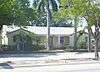 Dr. Kennedy Homes Historic District |
January 12, 2012 (#11000179) |
1004 W Broward Blvd 26°07′17″N 80°09′18″W |
Fort Lauderdale | originally added on April 6, 2011 |
gollark: That's *a* language you *can* use.
gollark: LIES!
gollark: Scripts are just a subset of software.
gollark: So what?
gollark: Stuff programmed in it is also software.
See also
| Wikimedia Commons has media related to National Register of Historic Places in Broward County, Florida. |
References
- The latitude and longitude information provided in this table was derived originally from the National Register Information System, which has been found to be fairly accurate for about 99% of listings. Some locations in this table may have been corrected to current GPS standards.
- "National Register of Historic Places: Weekly List Actions". National Park Service, United States Department of the Interior. Retrieved on August 14, 2020.
- Numbers represent an ordering by significant words. Various colorings, defined here, differentiate National Historic Landmarks and historic districts from other NRHP buildings, structures, sites or objects.
- "National Register Information System". National Register of Historic Places. National Park Service. March 13, 2009.
- The eight-digit number below each date is the number assigned to each location in the National Register Information System database, which can be viewed by clicking the number.
- "Bonnet House". www.bonnethouse.org.
- "Bryan Building". www.broward.org.
- "Hillsboro Inslet Lighthouse". www.broward.org.
- "Link Trainer Building". www.broward.org.
- "Sample-McDougald House". www.broward.org.
- "Joseph W. Young House". www.broward.org.

Municipalities and communities of Broward County, Florida, United States | ||
|---|---|---|
| Cities | | |
| Towns | ||
| Villages | ||
| CDPs | ||
| Unincorporated community | ||
| Indian reservations | ||
| Ghost towns |
| |
| Footnotes | ‡This populated place also has portions in an adjacent county or counties | |
This article is issued from Wikipedia. The text is licensed under Creative Commons - Attribution - Sharealike. Additional terms may apply for the media files.