National Register of Historic Places listings in Bay County, Florida
This is a list of the National Register of Historic Places listings in Bay County, Florida.
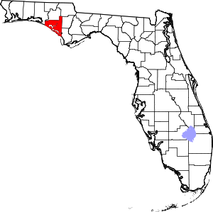
Location of Bay County in Florida
This is intended to be a complete list of the properties on the National Register of Historic Places in Bay County, Florida, United States. The locations of National Register properties for which the latitude and longitude coordinates are included below, may be seen in a map.[1]
There are 10 properties listed on the National Register in the county.
- This National Park Service list is complete through NPS recent listings posted August 14, 2020.[2]
| Alachua - Baker - Bay - Bradford - Brevard - Broward - Calhoun - Charlotte - Citrus - Clay - Collier - Columbia - DeSoto - Dixie - Duval - Escambia - Flagler - Franklin - Gadsden - Gilchrist - Glades - Gulf - Hamilton - Hardee - Hendry - Hernando - Highlands - Hillsborough (Tampa) - Holmes - Indian River - Jackson - Jefferson - Lafayette - Lake - Lee - Leon - Levy - Liberty - Madison - Manatee - Marion - Martin - Miami-Dade (Miami) - Monroe - Nassau - Okaloosa - Okeechobee - Orange - Osceola - Palm Beach - Pasco - Pinellas - Polk - Putnam - St. Johns - St. Lucie - Santa Rosa - Sarasota - Seminole - Sumter - Suwannee - Taylor - Union - Volusia - Wakulla - Walton - Washington |
Current listings
| [3] | Name on the Register[4] | Image | Date listed[5] | Location | City or town | Description |
|---|---|---|---|---|---|---|
| 1 | Camp Helen Historic District | 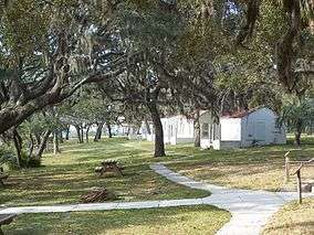 Camp Helen Historic District |
May 24, 2012 (#12000298) |
23937 Panama City Beach Pkwy. 30°16′21″N 85°59′35″W |
Panama City Beach | |
| 2 | GOVERNOR STONE (schooner) | 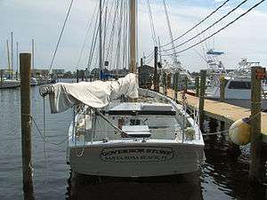 GOVERNOR STONE (schooner) |
December 4, 1991 (#91002063) |
Bayview Ave. 30°10′03″N 85°42′09″W |
Panama City | Was in Walton County at the time it was added to NRHP. |
| 3 | Latimer Cabin | 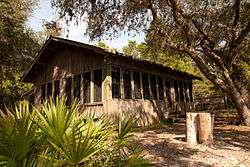 Latimer Cabin |
September 15, 2004 (#04000972) |
Northeast Powell Lake 30°16′45″N 85°59′09″W |
Panama City Beach | |
| 4 | Robert L. McKenzie House | 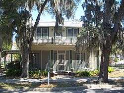 Robert L. McKenzie House |
August 21, 1986 (#86001728) |
17 East Third Court 30°09′15″N 85°39′38″W |
Panama City | |
| 5 | Panama Grammar School | January 21, 2020 (#100004888) |
101 East Seventh St. 30°09′40″N 85°39′35″W |
Panama City | ||
| 6 | A.A. Payne-John Christo, Sr. House | 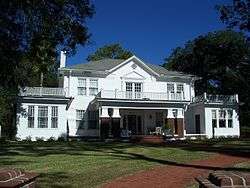 A.A. Payne-John Christo, Sr. House |
July 16, 2008 (#08000671) |
940 West Beach Drive 30°09′39″N 85°40′24″W |
Panama City | |
| 7 | St. Andrew School | 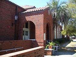 St. Andrew School |
August 14, 1997 (#97000839) |
3001 West 15th Street 30°10′31″N 85°42′06″W |
Panama City | |
| 8 | Sapp House | 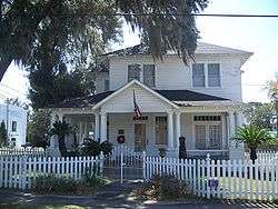 Sapp House |
October 4, 2003 (#03000991) |
224 Third Court 30°09′13″N 85°39′30″W |
Panama City | |
| 9 | Schmidt-Godert Farm | 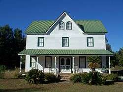 Schmidt-Godert Farm |
October 4, 2002 (#02001083) |
100 State Road 2297 30°08′48″N 85°30′02″W |
Panama City | |
| 10 | Sherman Arcade | 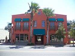 Sherman Arcade |
September 9, 1998 (#98001155) |
228 Harrison Avenue 30°09′16″N 85°39′39″W |
Panama City | |
| 11 | SS Tarpon (shipwreck) | 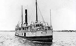 SS Tarpon (shipwreck) |
May 31, 2001 (#01000527) |
7.8 nautical miles (14.4 km) offshore Panama City 30°07′24″N 85°56′45″W |
Panama City | |
| 12 | Vamar Shipwreck Site | 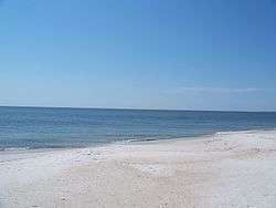 Vamar Shipwreck Site |
April 10, 2006 (#06000243) |
3.7 miles (6.0 km) offshore Mexico Beach 29°53′53″N 85°27′47″W |
Mexico Beach |
gollark: Distributed systems are not always *more* robust though.
gollark: Lots of temperature variation but otherwise sure.
gollark: I mean, my server has runs for multiple years with horrible amounts of dust and no maintenence.
gollark: Unless it is something which would plausibly run on a computer, I don't consider it programming.
gollark: We could make one of those alignment charts for programming definitions.
See also
| Wikimedia Commons has media related to National Register of Historic Places in Bay County, Florida. |
References
- The latitude and longitude information provided in this table was derived originally from the National Register Information System, which has been found to be fairly accurate for about 99% of listings. Some locations in this table may have been corrected to current GPS standards.
- "National Register of Historic Places: Weekly List Actions". National Park Service, United States Department of the Interior. Retrieved on August 14, 2020.
- Numbers represent an ordering by significant words. Various colorings, defined here, differentiate National Historic Landmarks and historic districts from other NRHP buildings, structures, sites or objects.
- "National Register Information System". National Register of Historic Places. National Park Service. March 13, 2009.
- The eight-digit number below each date is the number assigned to each location in the National Register Information System database, which can be viewed by clicking the number.

Municipalities and communities of Bay County, Florida, United States | ||
|---|---|---|
| Cities | | |
| CDPs | ||
| Unincorporated communities | ||
This article is issued from Wikipedia. The text is licensed under Creative Commons - Attribution - Sharealike. Additional terms may apply for the media files.