National Register of Historic Places listings in Jefferson County, Florida
This is a list of the National Register of Historic Places listings in Jefferson County, Florida.
Location of Jefferson County in Florida
This is intended to be a complete list of the properties and districts on the National Register of Historic Places in Jefferson County, Florida, United States. The locations of National Register properties and districts for which the latitude and longitude coordinates are included below, may be seen in a map.[1]
There are 22 properties and districts listed on the National Register in the county, and 2 boundary increases and decreases for properties.
- This National Park Service list is complete through NPS recent listings posted August 14, 2020.[2]
| Alachua - Baker - Bay - Bradford - Brevard - Broward - Calhoun - Charlotte - Citrus - Clay - Collier - Columbia - DeSoto - Dixie - Duval - Escambia - Flagler - Franklin - Gadsden - Gilchrist - Glades - Gulf - Hamilton - Hardee - Hendry - Hernando - Highlands - Hillsborough (Tampa) - Holmes - Indian River - Jackson - Jefferson - Lafayette - Lake - Lee - Leon - Levy - Liberty - Madison - Manatee - Marion - Martin - Miami-Dade (Miami) - Monroe - Nassau - Okaloosa - Okeechobee - Orange - Osceola - Palm Beach - Pasco - Pinellas - Polk - Putnam - St. Johns - St. Lucie - Santa Rosa - Sarasota - Seminole - Sumter - Suwannee - Taylor - Union - Volusia - Wakulla - Walton - Washington |
Current listings
| [3] | Name on the Register[4] | Image | Date listed[5] | Location | City or town | Description |
|---|---|---|---|---|---|---|
| 1 | Bethel School | 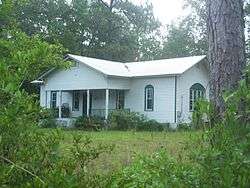 Bethel School |
October 12, 2001 (#01001084) |
County Road 149 30°36′49″N 83°50′16″W |
Monticello | |
| 2 | Denham-Lacy House | 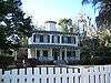 Denham-Lacy House |
May 6, 1982 (#82002376) |
555 Palmer Mill Road 30°32′36″N 83°52′25″W |
Monticello | |
| 3 | Dennis-Coxetter House | 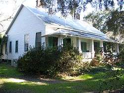 Dennis-Coxetter House |
October 20, 1988 (#88002025) |
Junction of State Roads 59 and 158 30°28′41″N 84°01′23″W |
Lloyd | |
| 4 | Girardeau House | 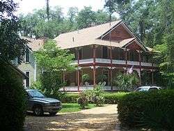 Girardeau House |
June 30, 2011 (#11000382) |
950 East Washington Street 30°32′44″N 83°51′42″W |
Monticello | |
| 5 | Jefferson County Jail | 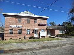 Jefferson County Jail |
January 15, 2014 (#13001072) |
380 West Dogwood Street 30°32′45″N 83°52′21″W |
Monticello | |
| 6 | Letchworth Mounds Archaeological Site | 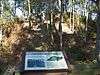 Letchworth Mounds Archaeological Site |
December 15, 2010 (#10001034) |
4500 Sunray Road 30°31′19″N 83°59′26″W |
Tallahassee vicinity | |
| 7 | Lloyd Historic District | 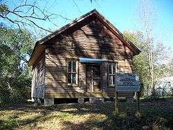 Lloyd Historic District |
September 5, 1991 (#91001374) |
Roughly Main Street north of Bond Street and Bond east of Main 30°28′43″N 84°01′25″W |
Lloyd | There was a boundary decrease on June 27, 2002 (refnum 02000710) |
| 8 | Lloyd Railroad Depot | 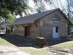 Lloyd Railroad Depot |
December 2, 1974 (#74000645) |
Near the junction of State Road 59 and Lester Lawrence Road 30°28′40″N 84°01′19″W |
Lloyd | |
| 9 | Lloyd Woman's Club | 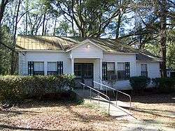 Lloyd Woman's Club |
August 10, 1998 (#98000926) |
Bond Street 30°28′39″N 84°01′38″W |
Lloyd | Part of the Clubhouses of Florida's Woman's Clubs MPS |
| 10 | Lloyd-Bond House | 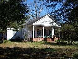 Lloyd-Bond House |
November 1, 1984 (#84000198) |
Bond Street 30°28′41″N 84°01′24″W |
Lloyd | |
| 11 | Lyndhurst Plantation | 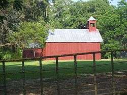 Lyndhurst Plantation |
April 2, 1973 (#73000582) |
15 miles (24 km) northeast of Monticello off Ashville Road 30°35′15″N 83°39′11″W |
Monticello | |
| 12 | Asa May House | 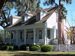 Asa May House |
December 15, 1972 (#72000329) |
North of the junction of U.S. Routes 19 and 27 30°24′52″N 83°54′40″W |
Capps | |
| 13 | Monticello High School | 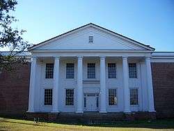 Monticello High School |
March 25, 1999 (#99000373) |
425 West Washington Street 30°32′40″N 83°52′31″W |
Monticello | |
| 14 | Monticello Historic District | 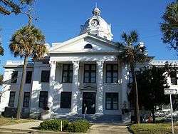 Monticello Historic District |
August 19, 1977 (#77000405) |
Irregular pattern along Madison, Jefferson, Dogwood, and Washington Streets 30°32′43″N 83°52′05″W |
Monticello | |
| 15 | Palmer House | 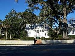 Palmer House |
November 21, 1978 (#78000947) |
Palmer Mill Road and South Jefferson Street 30°32′37″N 83°52′16″W |
Monticello | |
| 16 | Palmer-Perkins House | 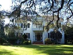 Palmer-Perkins House |
July 10, 1979 (#79000674) |
625 West Palmer Mill Road; also Walnut Street 30°32′38″N 83°52′30″W |
Monticello | Walnut Street represents a boundary increase, on March 18, 1986 (refnum 86000466). |
| 17 | Perkins Opera House | 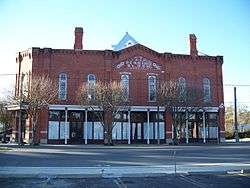 Perkins Opera House |
September 14, 1972 (#72000330) |
Washington Street and Courthouse Square 30°32′41″N 83°52′15″W |
Monticello | |
| 18 | San Joseph de Ocuya Site |  San Joseph de Ocuya Site |
May 7, 1973 (#73000580) |
Address Restricted |
Lloyd | |
| 19 | San Juan De Aspalaga Site | San Juan De Aspalaga Site |
May 7, 1973 (#73000581) |
Address Restricted |
Wacissa | |
| 20 | San Miguel de Asile Mission Site | San Miguel de Asile Mission Site |
December 17, 1974 (#74000644) |
Address Restricted |
Lamont | |
| 21 | Turnbull-Ritter House | 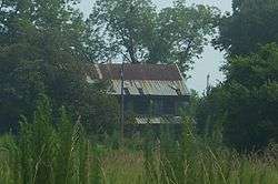 Turnbull-Ritter House |
July 18, 1979 (#79000673) |
Northwest of Lamont off U.S. Route 19 30°28′28″N 83°54′18″W |
Lamont | |
| 22 | Wirick-Simmons House | 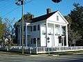 Wirick-Simmons House |
June 30, 1972 (#72000331) |
Jefferson and Pearl Streets 30°32′46″N 83°52′12″W |
Monticello |
gollark: <@140350547910852608> DuckDNS is nice.
gollark: One good way to do VPNing is to just rent a VPS and install a VPN server on that.
gollark: What exactly *are* registered DIMMs?
gollark: You'd expect them to have noticed that issue while it was being developed.
gollark: I had the same problem with it, no idea why.
See also
| Wikimedia Commons has media related to National Register of Historic Places in Jefferson County, Florida. |
References
- The latitude and longitude information provided in this table was derived originally from the National Register Information System, which has been found to be fairly accurate for about 99% of listings. Some locations in this table may have been corrected to current GPS standards.
- "National Register of Historic Places: Weekly List Actions". National Park Service, United States Department of the Interior. Retrieved on August 14, 2020.
- Numbers represent an ordering by significant words. Various colorings, defined here, differentiate National Historic Landmarks and historic districts from other NRHP buildings, structures, sites or objects.
- "National Register Information System". National Register of Historic Places. National Park Service. March 13, 2009.
- The eight-digit number below each date is the number assigned to each location in the National Register Information System database, which can be viewed by clicking the number.

Municipalities and communities of Jefferson County, Florida, United States | ||
|---|---|---|
| City | | |
| CDPs | ||
| Unincorporated communities | ||
| Ghost towns |
| |
| Plantations | ||
| Footnote |
| |
This article is issued from Wikipedia. The text is licensed under Creative Commons - Attribution - Sharealike. Additional terms may apply for the media files.