National Register of Historic Places listings in Brevard County, Florida
This is a list of the National Register of Historic Places listings in Brevard County, Florida.

Location of Brevard County in Florida
This is intended to be a complete list of the properties and districts on the National Register of Historic Places in Brevard County, Florida, United States. The locations of National Register properties and districts for which the latitude and longitude coordinates are included below, may be seen in a map.[1]
There are 43 properties and districts listed on the National Register in the county, including 2 National Historic Landmarks.
- This National Park Service list is complete through NPS recent listings posted August 14, 2020.[2]
| Alachua - Baker - Bay - Bradford - Brevard - Broward - Calhoun - Charlotte - Citrus - Clay - Collier - Columbia - DeSoto - Dixie - Duval - Escambia - Flagler - Franklin - Gadsden - Gilchrist - Glades - Gulf - Hamilton - Hardee - Hendry - Hernando - Highlands - Hillsborough (Tampa) - Holmes - Indian River - Jackson - Jefferson - Lafayette - Lake - Lee - Leon - Levy - Liberty - Madison - Manatee - Marion - Martin - Miami-Dade (Miami) - Monroe - Nassau - Okaloosa - Okeechobee - Orange - Osceola - Palm Beach - Pasco - Pinellas - Polk - Putnam - St. Johns - St. Lucie - Santa Rosa - Sarasota - Seminole - Sumter - Suwannee - Taylor - Union - Volusia - Wakulla - Walton - Washington |
Current listings
| [3] | Name on the Register[4] | Image | Date listed[5] | Location | City or town | Description |
|---|---|---|---|---|---|---|
| 1 | Aladdin Theater | 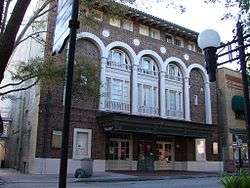 Aladdin Theater |
October 17, 1991 (#91001541) |
300 Brevard Avenue 28°21′19″N 80°43′35″W |
Cocoa | |
| 2 | Barton Avenue Residential District | 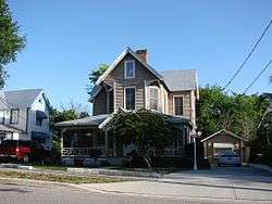 Barton Avenue Residential District |
August 21, 1992 (#92001046) |
11-59 Barton Avenue 28°19′48″N 80°43′12″W |
Rockledge | |
| 3 | Cape Canaveral Air Force Station |  Cape Canaveral Air Force Station |
April 16, 1984 (#84003872) |
Launch Pads 5, 6, 13, 14, 19, 26, 34, and Mission Control Center 28°28′26″N 80°34′28″W |
Cocoa | |
| 4 | Central Instrumentation Facility | 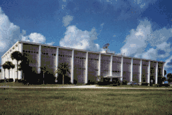 Central Instrumentation Facility |
January 21, 2000 (#99001635) |
Kennedy Space Center 28°31′27″N 80°39′22″W |
Merritt Island | |
| 5 | City Point Community Church | 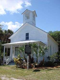 City Point Community Church |
June 20, 1995 (#95000731) |
3783 North Indian River Drive 28°25′23″N 80°45′11″W |
Cocoa | |
| 6 | Cocoa Junior High School | 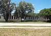 Cocoa Junior High School |
April 3, 2019 (#100003581) |
307 Blake Ave. 28°21′15″N 80°44′19″W |
Cocoa | Part of the Florida's Historic Black Public Schools MPS |
| 7 | Cocoa Post Office | 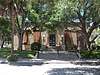 Cocoa Post Office |
April 2, 2019 (#100003582) |
435 Brevard Ave. 28°21′14″N 80°43′35″W |
Cocoa | Part of the Florida's New Deal Resources MPS |
| 8 | Community Chapel of Melbourne Beach |  Community Chapel of Melbourne Beach |
May 14, 1992 (#92000505) |
501 Ocean Avenue 28°04′06″N 80°33′49″W |
Melbourne Beach | |
| 9 | Crawlerway | 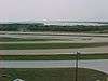 Crawlerway |
January 21, 2000 (#99001641) |
Kennedy Space Center 28°36′13″N 80°37′39″W |
Merritt Island | |
| 10 | J. R. Field Homestead |  J. R. Field Homestead |
September 11, 1997 (#97001121) |
750 Field Manor Drive 28°23′53″N 80°43′00″W |
Indianola | |
| 11 | Florida Power and Light Company Ice Plant | _002.jpg) Florida Power and Light Company Ice Plant |
November 17, 1982 (#82001033) |
1604 South Harbor City Boulevard 28°34′13″N 80°36′15″W |
Melbourne | |
| 12 | William H. Gleason House | 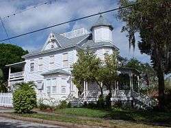 William H. Gleason House |
January 25, 1997 (#96001608) |
1736 Pineapple Avenue 28°08′06″N 80°37′45″W |
Melbourne | |
| 13 | Green Gables | _003.jpg) Green Gables |
May 18, 2016 (#16000269) |
1501 South Harbor City 28°05′06″N 80°36′22″W |
Melbourne | |
| 14 | Headquarters Building | Headquarters Building |
December 1, 2000 (#99001644) |
Kennedy Space Center 28°31′27″N 80°39′04″W |
Merritt Island | |
| 15 | Dr. George E. Hill House | 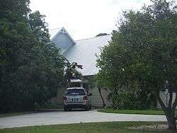 Dr. George E. Hill House |
March 3, 1994 (#93000819) |
870 Indianola Drive 28°23′45″N 80°43′09″W |
Merritt Island | |
| 16 | Hotel Mims |  Hotel Mims |
July 28, 1995 (#95000913) |
3202 State Road 46 28°39′54″N 80°50′46″W |
Mims | |
| 17 | Indian Fields | April 14, 1994 (#94000358) |
Address Restricted |
Titusville | ||
| 18 | Jorgensen's General Store | 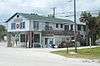 Jorgensen's General Store |
June 25, 1999 (#99000711) |
5390 U.S. Route 1 27°55′44″N 80°31′38″W |
Grant-Valkaria | |
| 19 | La Grange Church and Cemetery | 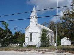 La Grange Church and Cemetery |
December 7, 1995 (#95001413) |
1575 Old Dixie Highway 28°38′23″N 80°49′39″W |
Titusville | |
| 20 | Launch Complex 39 | 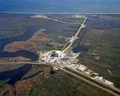 Launch Complex 39 |
May 24, 1973 (#73000568) |
Kennedy Space Center 28°36′08″N 80°37′43″W |
Titusville | |
| 21 | Launch Complex 39-Pad A | .jpg) Launch Complex 39-Pad A |
January 21, 2000 (#99001638) |
Kennedy Space Center 28°36′29″N 80°36′16″W |
Merritt Island | |
| 22 | Launch Complex 39-Pad B | 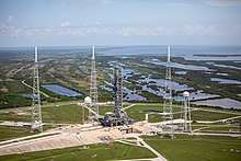 Launch Complex 39-Pad B |
January 21, 2000 (#99001639) |
Kennedy Space Center 28°37′37″N 80°37′16″W |
Merritt Island | |
| 23 | Launch Control Center | 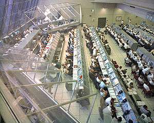 Launch Control Center |
January 21, 2000 (#99001645) |
Kennedy Space Center 28°35′07″N 80°38′59″W |
Merritt Island | |
| 24 | Melbourne Beach Pier | 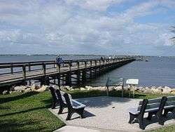 Melbourne Beach Pier |
April 12, 1984 (#84000829) |
Ocean Avenue and Riverside Drive 28°04′05″N 80°34′05″W |
Melbourne Beach | |
| 25 | Missile Crawler Transporter Facilities | Missile Crawler Transporter Facilities |
January 21, 2000 (#99001643) |
Kennedy Space Center 28°35′11″N 80°38′57″W |
Merritt Island | |
| 26 | Old Haulover Canal | 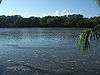 Old Haulover Canal |
December 19, 1978 (#78000262) |
Address Restricted 28°44′11″N 80°45′17″W |
Merritt Island | |
| 27 | Old St. Luke's Episcopal Church and Cemetery | 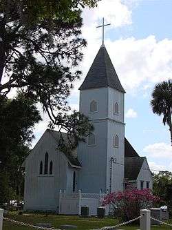 Old St. Luke's Episcopal Church and Cemetery |
June 15, 1990 (#90000848) |
5555 North Tropical Trail 28°27′26″N 80°43′03″W |
Courtenay | |
| 28 | Operations and Checkout Building | Operations and Checkout Building |
January 21, 2000 (#99001636) |
Kennedy Space Center 28°31′25″N 80°38′47″W |
Merritt Island | |
| 29 | Porcher House | 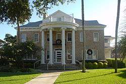 Porcher House |
January 6, 1986 (#86000023) |
434 Delannoy Avenue 28°21′45″N 80°43′32″W |
Cocoa | |
| 30 | Press Site–Clock and Flag Pole | 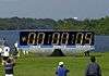 Press Site–Clock and Flag Pole |
January 21, 2000 (#99001637) |
Kennedy Space Center 28°34′56″N 80°38′44″W |
Merritt Island | |
| 31 | Pritchard House | 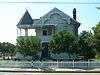 Pritchard House |
January 12, 1990 (#89002167) |
424 South Washington Avenue 28°36′37″N 80°48′28″W |
Titusville | |
| 32 | Judge George Robbins House | 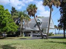 Judge George Robbins House |
January 12, 1990 (#89002168) |
703 Indian River Avenue 28°36′27″N 80°48′23″W |
Titusville | |
| 33 | Rockledge Drive Residential District | 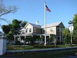 Rockledge Drive Residential District |
August 21, 1992 (#92001045) |
15-23 Rockledge Avenue, 219-1361 Rockledge Drive, and 1-11 Orange Avenue 28°20′14″N 80°43′13″W |
Rockledge | |
| 34 | James Wadsworth Rossetter House | 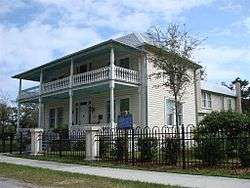 James Wadsworth Rossetter House |
July 27, 2005 (#05000734) |
1328 Houston Street 28°07′42″N 80°37′34″W |
Melbourne | |
| 35 | Spell House | 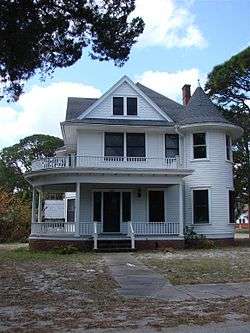 Spell House |
January 12, 1990 (#89002166) |
1200 Riverside Drive 28°36′07″N 80°48′22″W |
Titusville | |
| 36 | St. Gabriel's Episcopal Church | 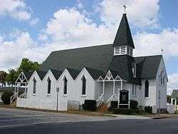 St. Gabriel's Episcopal Church |
December 5, 1972 (#72000302) |
414 Palm Avenue 28°36′28″N 80°48′39″W |
Titusville | |
| 37 | St. Joseph's Catholic Church | _001.jpg) St. Joseph's Catholic Church |
December 3, 1987 (#87000816) |
Miller Street, Northeast 28°02′00″N 80°35′12″W |
Palm Bay | |
| 38 | Titusville Commercial District | 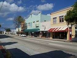 Titusville Commercial District |
January 10, 1990 (#89002164) |
Roughly bounded by Julia Street, Hopkins Avenue, Main Street, and Indian River Avenue 28°36′43″N 80°48′26″W |
Titusville | |
| 39 | Valencia Subdivision Residential District | 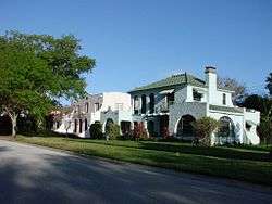 Valencia Subdivision Residential District |
August 21, 1992 (#92001047) |
14-140 Valencia Road, 825-827 Osceola Drive, and 24-28 Orange Avenue 28°20′11″N 80°43′18″W |
Rockledge | |
| 40 | Vehicle Assembly Building-High Bay and Low Bay | 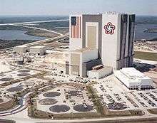 Vehicle Assembly Building-High Bay and Low Bay |
January 21, 2000 (#99001642) |
Kennedy Space Center 28°35′08″N 80°39′05″W |
Merritt Island | |
| 41 | Wager House | 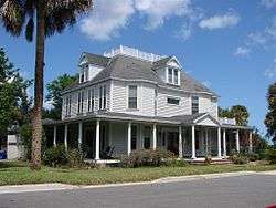 Wager House |
January 10, 1990 (#89002165) |
621 Indian River Avenue 28°36′29″N 80°48′23″W |
Titusville | |
| 42 | Marion S. Whaley Citrus Packing House | 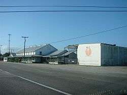 Marion S. Whaley Citrus Packing House |
April 8, 1993 (#93000286) |
2275 U.S. Route 1 28°18′46″N 80°42′37″W |
Rockledge | |
| 43 | Windover Archeological Site (8BR246) | 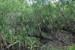 Windover Archeological Site (8BR246) |
April 20, 1987 (#87000810) |
Address Restricted |
Titusville |
gollark: <@!506482395269169153> Update PotatOS to the latest version with `upd` and run `ccemux config`.
gollark: * CraftOS on CCEmuX
gollark: If you do it in vanilla CC the screen just goes black.
gollark: Oh, I don't think you can do that.
gollark: What did you expect it to do?
See also
| Wikimedia Commons has media related to National Register of Historic Places in Brevard County, Florida. |
References
- The latitude and longitude information provided in this table was derived originally from the National Register Information System, which has been found to be fairly accurate for about 99% of listings. Some locations in this table may have been corrected to current GPS standards.
- "National Register of Historic Places: Weekly List Actions". National Park Service, United States Department of the Interior. Retrieved on August 14, 2020.
- Numbers represent an ordering by significant words. Various colorings, defined here, differentiate National Historic Landmarks and historic districts from other NRHP buildings, structures, sites or objects.
- "National Register Information System". National Register of Historic Places. National Park Service. March 13, 2009.
- The eight-digit number below each date is the number assigned to each location in the National Register Information System database, which can be viewed by clicking the number.

Municipalities and communities of Brevard County, Florida, United States | ||
|---|---|---|
| Cities | | |
| Towns | ||
| CDPs | ||
| Unincorporated communities | ||
This article is issued from Wikipedia. The text is licensed under Creative Commons - Attribution - Sharealike. Additional terms may apply for the media files.