Florida State Road 405
State Road 405 (SR 405) is a state highway making a sweeping arc in Titusville, Florida, and providing a major access route for the Kennedy Space Center on nearby Merritt Island. The northern terminus of SR 405 is an intersection with North Washington Avenue (U.S. Route 1 (US 1) and SR 5) in downtown Titusville; the eastern terminus is at the Space Center entrance just west of County Road 3 (CR 3). It is locally known as South Street, Columbia Boulevard, and the NASA Causeway.
| ||||
|---|---|---|---|---|
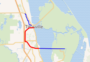
SR 405 in red, CR 405 in blue | ||||
| Route information | ||||
| Maintained by FDOT | ||||
| Length | 9.828 mi[1] (15.817 km) | |||
| Major junctions | ||||
| East end | ||||
| North end | ||||
| Location | ||||
| Counties | Brevard | |||
| Highway system | ||||
| ||||

Route description
South of Cheney Highway (SR 50), SR 405 is signed east–west; north of SR 50, SR 405 is signed north–south. It parallels Interstate 95 (I-95 or SR 9) for 2.2 miles (3.5 km) - from Cheney Highway to Willis Drive - before veering off the northeast to become the residential South Street.
In addition, SR 405 passes by Vectorspace Research Park (home of Astronaut Hall of Fame and U.S. Space Camp), Space Coast Regional Airport (formerly Ti-Co (Titusville-Cocoa) Airport) and Enchanted Forest Park.
Major intersections
.jpg)
The entire route is in Titusville, Brevard County.
| mi[1] | km | Destinations | Notes | ||
|---|---|---|---|---|---|
| 0.000 | 0.000 | Kennedy Space Center | |||
| 0.12[2] | 0.19 | Vectorspace Boulevard - Astronaut Hall of Fame | |||
| 0.280 | 0.451 | south end of state maintenance | |||
| 0.50 | 0.80 | ||||
| 2.292 | 3.689 | ||||
| 4.686 | 7.541 | ||||
| 10.062 | 16.193 | ||||
| 10.108 | 16.267 | ||||
| 1.000 mi = 1.609 km; 1.000 km = 0.621 mi | |||||
References
- FDOT straight line diagrams Archived March 6, 2014, at the Wayback Machine, accessed March 2014
- Google Maps distance