List of islands of Croatia
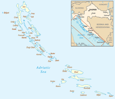
This is a list of islands of Croatia. There are over a thousand islands in Croatia, the exact number varying by definitions, and they cover a total area of about 3,300 km2 (1,300 sq mi).[1] The number and classification of islands in Croatia varies over time and by different measurements, causing some domestic controversy when discrepancies are found.[2]

Largest islands
These are the larger ones, sorted approximately from northwest to southeast:
Northern seacoast
Northern Dalmatia
Hydrographic Institute definitions
The Hydrographic Institute of the Republic of Croatia classifies all landforms surrounded by water in the Adriatic Sea as islands (Croatian: otoci), islets (otočići) and rocks (hridi). The categorization is determined according to their surface area. Rocks are defined as islets smaller than 0.1 km², islets are between 0.1 and 1.0 km² and islands proper are bigger than 1.0 km².[3]
| # |
Number |
Area (km²) |
Percentage of total area |
Coastline length (km) |
Percentage of total coastline |
|---|---|---|---|---|---|
| Islands | 79 | 3,195.71 | 3,573.81 | ||
| Islets | 525 | 62.41 | 717.80 | ||
| Rocks and rocks awash | 642 | 1.44 | 106.82 | ||
| Total | 1246 | 3,259.57 | 4,398.44 | ||
| Source: T. Duplančić Leder, T. Ujević, M. Čala: Coastline lengths and areas... Geoadria, 9/1, 5-32, 2004.[3] | |||||
According to measurements obtained in early 2000s the largest islands in the Adriatic Sea are Cres with an area of 405.70 km2, and Krk with an area of 405.22 km2 (In earlier literature, including atlases, Krk was usually cited as the largest island). The smallest island is Smokvica Vela (Kornati) with an area of 1.04 km2.[3] The island with the longest coastline of 302.47 km (187.95 mi) is Pag, being the fifth according to area value and the island with the shortest coastline length of 5.8 km (3.60 mi) is Vele Orjule.[3] The biggest islet is Badija with an area of 0.97 km2, while the smallest one is Galicija covering 0.01 km2.[3]
List of islands
The following table lists the 79 Croatian islands having an area of 1 km2 or more, sorted by their surface area from largest to smallest. The area data is rounded off to the second decimal.
| # | Island | Area (km2) | Population | County | Coordinates |
|---|---|---|---|---|---|
| 1 | Cres | 405.70 | 3,184 | Primorje-Gorski Kotar | 44°52′07″N 14°25′22″E |
| 2 | Krk | 405.22 | 17,860 | Primorje-Gorski Kotar | 45°04′27″N 14°36′28″E |
| 3 | Brač | 395.44 | 14,031 | Split-Dalmatia | 43°19′26″N 16°38′33″E |
| 4 | Hvar | 297.38 | 11,103 | Split-Dalmatia | 43°08′39″N 16°46′46″E |
| 5 | Pag | 284.18 | 8,398 | Lika-Senj / Zadar | 44°28′59″N 14°58′00″E |
| 6 | Korčula | 271.47 | 16,182 | Dubrovnik-Neretva | 42°56′20″N 16°54′11″E |
| 7 | Dugi Otok | 113.30 | 1,772 | Zadar | 44°00′40″N 15°02′15″E |
| 8 | Mljet | 98.02 | 1,111 | Dubrovnik-Neretva | 42°44′52″N 17°31′52″E |
| 9 | Vis | 89.72 | 3,617 | Split-Dalmatia | 43°02′41″N 16°09′15″E |
| 10 | Rab | 86.16 | 9,480 | Primorje-Gorski Kotar | 44°46′14″N 14°46′32″E |
| 11 | Pašman | 60.11 | 2,711 | Zadar | 43°57′05″N 15°21′03″E |
| 12 | Šolta | 58.18 | 1,479 | Split-Dalmatia | 43°22′46″N 16°17′51″E |
| 13 | Lošinj | 74 | 7,771 | Primorje-Gorski Kotar | |
| 14 | Ugljan | 51.05 | 6,182 | Zadar | 44°05′03″N 15°09′34″E |
| 15 | Lastovo | 40.82 | 835 | Dubrovnik-Neretva | 42°45′15″N 16°52′31″E |
| 16 | Kornat | 32.44 | 7 | Šibenik-Knin | 43°48′33″N 15°19′09″E |
| 17 | Čiovo | 28.13 | 4,455 | Split-Damatia | 43°30′01″N 16°17′53″E |
| 18 | Olib | 26.14 | 147 | Zadar | 44°22′41″N 14°47′08″E |
| 19 | Molat | 22.18 | 207 | Zadar | 44°13′55″N 14°50′33″E |
| 20 | Vir | 22.08 | 1,608 | Zadar | 44°18′16″N 15°03′59″E |
| 22 | Murter | 17.58 | 5,060 | Šibenik-Knin | 43°48′04″N 15°36′46″E |
| 23 | Unije | 16.88 | 90 | Primorje-Gorski Kotar | 44°38′56″N 14°15′25″E |
| 24 | Iž | 16.51 | 557 | Zadar | 44°02′20″N 15°06′53″E |
| 25 | Šipan | 16.22 | 436 | Dubrovnik-Neretva | 42°43′42″N 17°52′44″E |
| 26 | Sestrunj | 15.12 | 48 | Zadar | 44°09′22″N 14°59′27″E |
| 27 | Žirje | 15.08 | 124 | Šibenik-Knin | 43°39′05″N 15°39′41″E |
| 28 | Žut | 14.83 | 0 | Šibenik-Knin | 43°51′47″N 15°18′51″E |
| 29 | Silba | 14.27 | 265 | Zadar | 44°22′56″N 14°41′41″E |
| 30 | Prvić (Krk) | 12.76 | 0 | Primorje-Gorski Kotar | 44°54′38″N 14°48′05″E |
| 31 | Drvenik Veliki | 11.70 | 168 | Split-Dalmatia | 43°26′39″N 16°08′43″E |
| 32 | Ist | 9.73 | 202 | Zadar | 44°16′28″N 14°45′51″E |
| 33 | Premuda | 8.67 | 58 | Zadar | 44°19′44″N 14°37′31″E |
| 34 | Plavnik | 8.64 | 0 | Primorje-Gorski Kotar | 44°58′17″N 14°31′30″E |
| 35 | Maun | 8.50 | 0 | Zadar | 44°25′42″N 14°55′21″E |
| 36 | Šćedro | 8.37 | 0 | Split-Dalmatia | 43°05′18″N 16°42′07″E |
| 37 | Zlarin | 8.05 | 276 | Šibenik-Knin | 43°41′19″N 15°50′56″E |
| 38 | Kaprije | 7.12 | 143 | Šibenik-Knin | 43°41′51″N 15°42′01″E |
| 39 | Sveti Grgur | 6.38 | 0 | Primorje-Gorski Kotar | 44°52′02″N 14°45′35″E |
| 40 | Biševo | 5.92 | 19 | Split-Dalmatia | 42°58′27″N 16°00′39″E |
| 41 | Veliki Brijun | 5.72 | 0 | Istria | |
| 42 | Ilovik | 5.50 | 104 | Primorje-Gorski Kotar | |
| 43 | Sveti Klement | 5.28 | 0 | Split-Dalmatia | |
| 44 | Dolin | 4.61 | 0 | Primorje-Gorski Kotar | |
| 45 | Goli Otok | 4.54 | 0 | Primorje-Gorski Kotar | |
| 46 | Lopud | 4.38 | 269 | Dubrovnik-Neretva | |
| 47 | Svetac | 4.19 | 0 | Split-Dalmatia | |
| 48 | Zverinac | 4.18 | 48 | Zadar | |
| 49 | Sušac | 4.03 | 0 | Dubrovnik-Neretva | |
| 50 | Škarda | 3.78 | 0 | Zadar | |
| 51 | Susak | 3.77 | 188 | Primorje-Gorski Kotar | |
| 52 | Rava | 3.63 | 98 | Zadar | |
| 53 | Rivanj | 3.62 | 22 | Zadar | |
| 54 | Drvenik Mali | 3.43 | 54 | Split-Dalmatia | |
| 55 | Kakan | 3.39 | 0 | Šibenik-Knin | |
| 56 | Zmajan | 3.30 | 0 | Šibenik-Knin | |
| 57 | Jakljan | 3.07 | 0 | Dubrovnik-Neretva | |
| 58 | Prežba | 2.80 | 0 | Dubrovnik-Neretva | |
| 59 | Tijat | 2.78 | 0 | ||
| 60 | Piškera | 2.67 | 0 | Zadar | |
| 61 | Zeča | 2.55 | 0 | ||
| 62 | Koločep | 2.44 | 294 | Dubrovnik-Neretva | |
| 63 | Prvić (Šibenik) | 2.41 | 453 | ||
| 64 | Vrgada | 2.32 | 242 | ||
| 65 | Lavdara | 2.27 | 0 | ||
| 66 | Tun Veli | 2.21 | 0 | ||
| 67 | Škrda | 2.05 | 0 | ||
| 68 | Levrnaka | 1.84 | 0 | ||
| 69 | Lavsa | 1.78 | 0 | ||
| 70 | Sit | 1.77 | 0 | ||
| 71 | Kurba Vela | 1.74 | 0 | ||
| 72 | Mrčara | 1.45 | 0 | Dubrovnik-Neretva | |
| 73 | Arta Velika | 1.28 | 0 | Šibenik-Knin | |
| 74 | Vele Srakane | 1.18 | 8 | ||
| 75 | Katina | 1.13 | 0 | ||
| 76 | Planik | 1.09 | 0 | ||
| 77 | Mali Brijun | 1.07 | 0 | ||
| 78 | Vele Orjule | 1.06 | 0 | ||
| 79 | Smokvica Vela | 1.05 | 0 |
Selected islets
The following is an incomplete list of islets.
- Badija
- Brijuni
- Farfarikulac, island in the Telašćica Nature Park
- Galešnjak
- Galijula, southernmost Croatian island.
- Jabuka
- Jaz
- Knežak
- Košljun
- Kozjak
- Krapanj
- Lokrum
- Lunga (Kornat)
- Lupac
- Male Srakane
- Olipa
- Ošljak
- Palagruža
- Pokonji Dol, eastern-most island of the Paklinski otoci archipelago
- Radelj
- Ruda
- Sveti Andrija (Dubrovnik), uninhabited island near Dubrovnik
- Sveti Andrija (Rovinj), also known as Crveni otok (English: Red Island), off the coast of Rovinj
Bureau of Statistics definitions
The Croatian Bureau of Statistics uses data from the Geographical Department of the Faculty of Science of the University of Zagreb, which classifies a total of 1,185 islands, rocks and reefs: 48 inhabited islands, 670 uninhabited islands (Croatian: otoci), 389 rocks (hridi) and 78 reefs (grebeni).[4] The rocks and reefs are defined as the "rocky remains of an islet or a rocky formation destroyed by abrasion", differentiated by whether they are "always above sea level" or "at, under or above sea level (at low tide)", respectively.[4]
Other definitions
Mark Biondich's Eastern Europe: An Introduction to the People, Lands, and Culture puts the number of Croatian islands at 1,246. Of these, there are 718 islands in the conventional sense, 389 cliffs, and 78 reefs.[5]
References
- Duplančić Leder, Tea; Ujević, Tin; Čala, Mendi (June 2004). "Coastline lengths and areas of islands in the Croatian part of the Adriatic Sea determined from the topographic maps at the scale of 1: 25 000" (PDF). Geoadria. Zadar. 9 (1): 5–32. doi:10.15291/geoadria.127. Retrieved 25 November 2019.
- "Kartografi protiv Turističke zajednice - Imamo 1246 otoka, tko je izgubio dva, ne znamo". Jutarnji list (in Croatian). 8 June 2010. Retrieved 30 August 2016.
- Duplančić Leder, Tea; Ujević, Tin; Čala, Mendi (June 2004). "Coastline lengths and areas of islands in the Croatian part of the Adriatic Sea as determined from topographic maps at a 1:25,000 scale" (PDF). Geoadria. Zadar, Croatia: Hrvatsko geografsko društvo - Zadar, Geography Department, University of Zadar. 9 (1). ISSN 1331-2294. Retrieved 30 August 2016.
- Croatian Bureau of Statistics (2009). "Geographical and meteorological data" (PDF). Statistical Yearbook for 2009. Croatian Bureau of Statistics. p. 44. Retrieved 30 August 2016.
- Biondich, Mark (2005). Eastern Europe: An Introduction to the People, Lands, and Culture, page 414. ABC-CLIO; ISBN 1-57607-800-0.
External links
- "The Islands Act (Refined Text)" (PDF). Ministry of the Sea, Transport and Infrastructure. Archived from the original (PDF) on 7 August 2011. Retrieved 30 August 2016.
