List of census-designated places in Oklahoma
The list of census-designated places in Oklahoma contains those areas defined by the US Census Bureau as CDPs. A CDP is a "statistical entity ... comprising a densely settled concentration of population that is not within an incorporated place". CDPs have no governmental powers. For some reason the majority of CDPs in Oklahoma are in the northeastern quarter of the state.
| Images of the Tiawah CDP and of the actual community |
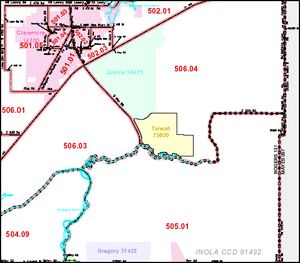 The Tiawah CDP (in yellow) lies east of Oklahoma State Highway 88. |
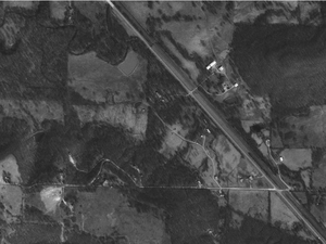 The actual Tiawah community lies on either side of Highway 88 in the midst of the Tiawah Hills. |
Many of the CDPs were named for communities located within the defined entities, or for nearby communities. Where known, the associated communities are also listed for reference. The sources for the associated communities are primarily from Shirk's Oklahoma Place Names (ISBN 0-8061-2028-2), the United States Geological Survey, or the list of unincorporated communities in Oklahoma.
See also:
B
- Badger Lee – Seqoyah County
- Ballou – Mayes County
- Bee – Johnston County
- Belfonte – Sequoyah County
- Bell – Adair County
- Bison – Garfield County
- Blackgum – Sequoyah County
- Blue – Bryan County
- Box – Sequoyah County
- Brent – Sequoyah County
- Briggs – Cherokee County
- Brush Creek – Delaware County
- Brushy – Sequoyah County
- Bull Hollow – Delaware County
- Bushyhead – Rogers County
- Butler – Delaware County
C
- Carlisle – Sequoyah County
- Cartwright – Bryan County
- Cayuga – Delaware County
- Cedar Crest – Mayes County
- Cherry Tree – Adair County
- Chester – Major County
- Chewey – Adair County
- Christie – Adair County
- Cleora – Delaware County
- Cloud Creek – Delaware County
- Copeland – Delaware County
D
- Dale – Pottawatomie County
- Deer Lick – Delaware County
- Dennis – Delaware County
- Dodge – Delaware County
- Dotyville – Ottawa County
- Dripping Springs – Delaware County
- Drowning Creek – Delaware County
- Dry Creek – Cherokee County
- Duchess Landing – McIntosh County
- Dwight Mission – Sequoyah County
E
- Eagletown – McCurtain County
- Eldon – Cherokee County
- Elm Grove – Adair County
- Evening Shade – Sequoyah County
F
- Fairfield – Adair County
- Felt – Cimarron County
- Flint Creek – Delaware County
- Flute Springs – Sequoyah County
G
J
- Justice – Rogers County
L
M
N
- Narcissa – Ottawa County
- Nardin – Kay County
- Nescatunga – Alfalfa County
- New Eucha – Delaware County
- Nicut – Sequoyah County
- Notchietown – Sequoyah County
P
- Park Hill – Cherokee County
- Peavine – Adair County
- Peggs – Cherokee County
- Pettit – Cherokee County
- Pin Oak Acres – Mayes County
- Piney – Adair County
- Pinhook Corner – Sequoyah County
- Proctor – Adair County
- Pump Back – Mayes County
R
- Redbird Smith – Sequoyah County
- Remy – Sequoyah County
- River Bottom – Muskogee County
- Rocky Ford – Delaware County
- Rocky Mountain – Adair County
- Rose – Mayes County
S
- Salem – Adair County
- Sams Corner – Mayes County
- Sand Hill – Muskogee County
- Scraper – Cherokee County
- Sequoyah – Rogers County
- Shady Grove – Cherokee County
- Shady Grove – McIntosh County
- Short – Sequoyah County
- Simms – Muskogee County
- Snake Creek – Mayes County
- Sour John – Muskogee County
- Steely Hollow – Cherokee County
- Stoney Point – Sequoyah County
- Swink – Choctaw County
- Sycamore – Delaware County
T
W
- Wauhillau – Adair County
- Welling – Cherokee County
- West Peavine – Adair County
- White Oak – Craig County
- Whitesboro – Le Flore County
- White Water – Delaware County
- Wickliffe – Mayes County
- Woodall – Cherokee County
Z