Gideon, Oklahoma
Gideon is an unincorporated community and census-designated place (CDP) in Cherokee County, Oklahoma, United States.[1] The population was 49 at the 2010 census.[2]
Gideon, Oklahoma | |
|---|---|
 Gideon | |
| Coordinates: 36°0′33″N 95°1′59″W | |
| Country | United States |
| State | Oklahoma |
| County | Cherokee |
| Area | |
| • Total | 1.2 sq mi (3.1 km2) |
| • Land | 1.2 sq mi (3.1 km2) |
| • Water | 0.0 sq mi (0.0 km2) |
| Population (2010) | |
| • Total | 49 |
| • Density | 41/sq mi (15.9/km2) |
| Time zone | UTC-6 (Central (CST)) |
| • Summer (DST) | UTC-5 (CST) |
| FIPS code | 40-29300 |
| GNIS feature ID | 1100447 |
Geography
Gideon is located northwest of the center of Cherokee County along Oklahoma State Highway 82. Tahlequah, the Cherokee County seat, is 9 miles (14 km) to the southeast, and Locust Grove is 16 miles (26 km) to the northwest.
According to the United States Census Bureau, the Gideon CDP has a total area of 1.2 square miles (3.1 km2), all land.[2]
gollark: Well, it is harder to have to semi-manually manage memory than to have it garbage collected, and it has issues like being stuck in the middle of moving to asynchronous code right now.
gollark: (praise Rust™, although I still find it somewhat harder to write stuff in than JS or whatever so I only use it for my more perf-sensitive projects)
gollark: Like Rust's `Option`, which is optimized to use null pointers or something, meaning it's basically only a compile-time performance cost.
gollark: There are *low-cost* ones.
gollark: Rust's pretty fast and has the neat safety thing going on.
References
- U.S. Geological Survey Geographic Names Information System: Gideon, Oklahoma
- "Geographic Identifiers: 2010 Demographic Profile Data (G001): Gideon CDP, Oklahoma". U.S. Census Bureau, American Factfinder. Archived from the original on February 18, 2015. Retrieved February 12, 2015.
Municipalities and communities of Cherokee County, Oklahoma, United States | ||
|---|---|---|
| City | 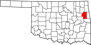 Cherokee County map | |
| Towns | ||
| CDPs | ||
| Other unincorporated communities | ||
| Indian reservation | ||
| Footnotes | ‡This populated place also has portions in an adjacent county or counties | |
This article is issued from Wikipedia. The text is licensed under Creative Commons - Attribution - Sharealike. Additional terms may apply for the media files.