Elm Grove, Oklahoma
Elm Grove is a census-designated place (CDP) in Adair County, Oklahoma, United States. The population was 198 at the 2010 census.[3]
Elm Grove, Oklahoma | |
|---|---|
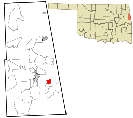 Location within Adair County and the state of Oklahoma | |
| Coordinates: 35°47′40″N 94°33′34″W | |
| Country | United States |
| State | Oklahoma |
| County | Adair |
| Area | |
| • Total | 1.7 sq mi (4.3 km2) |
| • Land | 1.7 sq mi (4.3 km2) |
| • Water | 0.0 sq mi (0.0 km2) |
| Elevation | 1,050 ft (320 m) |
| Population (2010) | |
| • Total | 198 |
| • Density | 119/sq mi (46.1/km2) |
| Time zone | UTC-6 (Central (CST)) |
| • Summer (DST) | UTC-5 (CDT) |
| FIPS code | 40-23575[1] |
| GNIS feature ID | 2584379[2] |
Geography
Elm Grove is located at 35°47′40″N 94°33′34″W, along Oklahoma State Highway 100. It is 4 miles (6 km) east of Stilwell, the county seat, and 3 miles (5 km) west of the Arkansas border.
According to the United States Census Bureau, the CDP has a total area of 1.7 square miles (4.3 km2), of which 0.0039 square miles (0.01 km2), or 0.25%, is water.[3]
gollark: Impressive.
gollark: I see.
gollark: Interesting. Exactly 4?
gollark: Does YOUR computer have four (4) blinky LED lights on it?
gollark: No, but it does have a headphone jack, unlike some smartphones.
References
- "U.S. Census website". United States Census Bureau. Retrieved 2008-01-31.
- "US Board on Geographic Names". United States Geological Survey. 2007-10-25. Retrieved 2008-01-31.
- "Geographic Identifiers: 2010 Demographic Profile Data (G001): Elm Grove CDP, Oklahoma". U.S. Census Bureau, American Factfinder. Archived from the original on February 12, 2020. Retrieved July 11, 2013.
Municipalities and communities of Adair County, Oklahoma, United States | ||
|---|---|---|
| City | 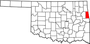 Adair County map | |
| Towns | ||
| CDPs | ||
| Other unincorporated communities | ||
| Indian reservation | ||
| Footnotes | ‡This populated place also has portions in an adjacent county or counties | |
This article is issued from Wikipedia. The text is licensed under Creative Commons - Attribution - Sharealike. Additional terms may apply for the media files.