Nescatunga, Oklahoma
Nescatunga is an unincorporated census-designated place (CDP) in Alfalfa County, Oklahoma, United States adjacent to Great Salt Plains State Park. The population was 70 as of the 2010 census.[2]
Nescatunga, Oklahoma | |
|---|---|
 Nescatunga | |
| Coordinates: 36°45′11″N 98°9′10″W | |
| Country | United States |
| State | Oklahoma |
| County | Alfalfa |
| Area | |
| • Total | 0.2 sq mi (0.6 km2) |
| • Land | 0.2 sq mi (0.6 km2) |
| • Water | 0 sq mi (0 km2) |
| Elevation | 1,145 ft (349 m) |
| Population | |
| • Total | 70 |
| • Density | 310/sq mi (119.8/km2) |
| Time zone | UTC-6 (Central (CST)) |
| • Summer (DST) | UTC-5 (CDT) |
| FIPS code | 40-50975[3] |
| GNIS feature ID | 2130055[1] |
History
Sans Orielle, an Osage Indian, along with other members of his tribe guided Indian Agent Major George C. Sibley and his party from Fort Osage, Missouri, to the Great Salt Plains area of present-day Alfalfa county in 1811. The Sibley party members are believed to have been the first white men to set sight on the salt plains, which Sibley called the Grand Saline. The Salt Fork of the Arkansas River, flowing through the plains, was known by the Osages as Nescatunga - meaning 'big salt water'.[4]
Nescatunga is adjacent to the Great Salt Plains Reservoir located on the Salt Fork of the Arkansas River. The creation of the dam and reservoir was a U.S. Army Corps of Engineers’ project in the late 1930s and early 1940s. It was completed in July, 1941 at a cost of $4.6 million.[4]
Geography
Nescatunga is located at 36°45′11″N 98°09′10″W[1] in eastern Alfalfa County. It is near the outlet of the Great Salt Plains Lake on the Salt Fork of the Arkansas River and is adjacent to Great Salt Plains State Park. Oklahoma State Highway 38 runs through the center of the community, leading south 10 miles (16 km) to Jet, the nearest incorporated town.[5]
Nescatunga's Census Bureau CDP has a total area of 0.23 square miles (0.6 km2), all of it land.[6]
References
- "Geographic Names Information System (GNIS)". United States Geological Survey. July 18, 2007. Retrieved June 19, 2016.
- "Geographic Identifiers: 2010 Demographic Profile Data (G001): Nescatunga CDP, Oklahoma". U.S. Census Bureau, American Factfinder. Archived from the original on February 12, 2020. Retrieved July 12, 2013.
- "U.S. Census website". United States Census Bureau. Retrieved 2008-01-31.
- "History of the Great Salt Plains Lake". U.S. Army Corps of Engineers. Retrieved June 22, 2016.
- General Highway Map - Alfalfa County, Oklahoma (PDF) (Map) (1992 ed.). Oklahoma Department of Transportation, Planning Division.
- "Nescatunga, OK Profile: Facts, Map & Data". OK HomeTownLocator. HTL, Inc. Retrieved June 23, 2016.
Municipalities and communities of Alfalfa County, Oklahoma, United States | ||
|---|---|---|
| City | 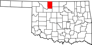 Alfalfa County map | |
| Towns | ||
| CDP | ||
| Other unincorporated communities | ||