List of Historic Sites of Japan (Wakayama)
National Historic Sites
As of 1 September 2019, twenty-six Sites have been designated as being of national significance (including one *Special Historic Site); Kumano Sanzan spans the prefectural borders with Mie, Ōmine Okugakemichi spans the prefectural borders with Nara, and Kumano Sankeimichi spans the prefectural borders with both Mie and Nara.[2][3][4]
| Site | Municipality | Comments | Image | Coordinates | Type | Ref. |
|---|---|---|---|---|---|---|
| *Iwasesenzuka Kofun Cluster 岩橋千塚古墳群 Iwasesenzuka kofun-gun | Wakayama | 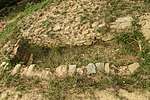 | 34°13′31″N 135°13′35″E | 1 | ||
| Isoma Rock Shelter Site 磯間岩陰遺跡 Isoma iwakage iseki | Tanabe | 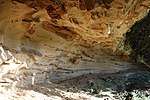 | 33°43′17″N 135°23′00″E | 1 | ||
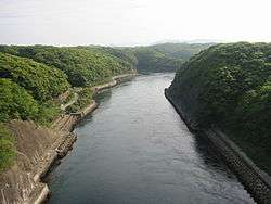
| Shimosato Kofun 下里古墳 Shimosato kofun | Nachikatsuura | 33°35′03″N 135°55′22″E | 1 | |||
| Kii Kokubun-ji Site 紀伊国分寺跡 Kii Kokubunji ato | Kinokawa | provincial temple of Kii Province | 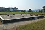 | 34°16′08″N 135°20′22″E | 3 | |
| Former Nate-juku Honjin 旧名手宿本陣 Kyū-Nate-juku honjin | Kinokawa | 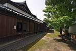 | 34°16′33″N 135°26′09″E | 6 | ||
| Kongōbu-ji Precinct 金剛峯寺境内 Kongōbuji keidai | Kōya | head temple of Koyasan Shingon Buddhism with multiple National Treasures; inscribed on the UNESCO World Heritage List as one of the Sacred Sites and Pilgrimage Routes in the Kii Mountain Range[5][6] | 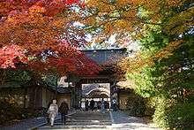 | 34°12′47″N 135°34′47″E | 3 | |
| Hiromura Dike 広村堤防 Hiromura teibō | Hirogawa |  | 34°01′35″N 135°10′14″E | 6 | ||
| Kōzanji Shell Mound 高山寺貝塚 Kōzanji kaizuka | Tanabe | 33°44′24″N 135°22′42″E | 1 | |||
| Kōyasan Chōishi 高野山町石 Kōyasan chōishi | Kōya, Katsuragi, Kudoyama | inscribed on the UNESCO World Heritage List as one of the Sacred Sites and Pilgrimage Routes in the Kii Mountain Range[5][6] | 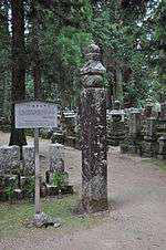 | 34°13′34″N 135°32′16″E | 3, 6 | |
| Negoro-ji Precinct 根来寺境内 Negoroji keidai | Iwade | 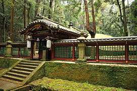 | 34°17′15″N 135°19′04″E | 3 | ||
| Misu Haiji Pagoda Site 三栖廃寺塔跡 Misu Haiji tō ato | Tanabe | 33°44′14″N 135°25′00″E | 3 | |||
| Shikagō Ichirizuka 四箇郷一里塚 Shikagō ichirizuka | Wakayama | 34°14′42″N 135°12′03″E | 6 | |||
| Ueno Haiji Site 上野廃寺跡 Ueno Haiji ato | Wakayama | 34°16′29″N 135°15′15″E | 3 | |||
| Shingū Castle Site and Mizuno Clan Graves 新宮城跡附水野家墓所 Shingū-jō ato tsuketari Mizuno-ke bosho | Shingū | 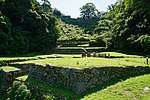 | 33°43′05″N 135°59′08″E | 2, 7 | ||
| Nishi Kokubun Pagoda Site 西国分塔跡 Nishi Kokubun tō ato | Iwade | 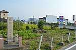 | 34°15′57″N 135°19′53″E | 3 | ||
| Ōtani Kofun 大谷古墳 Ōtani kofun | Wakayama | 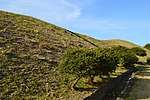 | 34°15′42″N 135°10′35″E | 1 | ||
| Niutsuhime Jinja Precinct 丹生都比売神社境内 Nyūtsuhime Jinja keidai | Katsuragi | inscribed on the UNESCO World Heritage List as one of the Sacred Sites and Pilgrimage Routes in the Kii Mountain Range[5][6] | 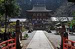 | 34°15′30″N 135°31′27″E | 3 | |
| Dōjō-ji Precinct 道成寺境内 Dōjōji keidai | Hidakagawa | 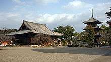 | 33°54′52″N 135°10′28″E | 3 | ||
| Hamaguchi Goryō Grave 浜口梧陵墓 Hamaguchi Goryō no haka | Hirogawa | 34°01′16″N 135°10′05″E | 7 | |||
| Myōe Kishū Sites and Tōba 明恵紀州遺跡率都婆 Myōe Kishū iseki sotsu tōba | Arida, Yuasa, Aridagawa | 34°04′18″N 135°09′35″E | 3, 7 | |||
| Narugami Shell Mound 鳴神貝塚 Narugami kaizuka | Wakayama | 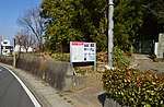 | 34°13′50″N 135°12′42″E | 1 | ||
| Wakayama Castle 和歌山城 Wakayama-jō | Wakayama | 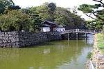 | 34°13′39″N 135°10′16″E | 2 | ||
| Wakayama Domain Tokugawa Clan Graves 和歌山藩主徳川家墓所 Wakayama-han-shu Tokugawa-ke bosho | Kainan | at Chōhō-ji | 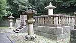 | 34°06′32″N 135°10′01″E | 7 | |
| Kumano Sanzan 熊野三山 Kumano sanzan | Shingū, Tanabe, Nachikatsuura | designation includes an area of Kihō in Mie Prefecture | 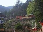 | 33°43′37″N 135°58′55″E | 3 | |
| Ōmine Okugakemichi 大峯奥駈道 Ōmine okugakemichi | Tanabe, Shingū | trail inscribed on the UNESCO World Heritage List as one of the Sacred Sites and Pilgrimage Routes in the Kii Mountain Range;[5][6] designation includes areas of Yoshino, Kurotaki, Kawakami, Tenkawa, Kamikitayama, Shimokitayama, Totsukawa, and Gojō in Nara Prefecture |  | 34°13′26″N 135°57′19″E | 3, 6 | |
| Kumano Sankeimichi 熊野参詣道 Kumano sankeimichi | Shingū, Tanabe, Nachikatsuura, Shirahama, Susami, Kōya | trails inscribed on the UNESCO World Heritage List among the Sacred Sites and Pilgrimage Routes in the Kii Mountain Range;[5][6] designation includes the Nakahechi (中辺路), Ōhechi (大辺路), Kohechi (小辺路), Iseji (伊勢路), Kumano River (熊野川), Shichirimi-hama (七里御浜), and Hano-no-Iwa (花の窟) and areas of Nosegawa and Totsukawa in Nara Prefecture and Kumano, Owase, Taiki, Kihoku, Mihama, and Kihō in Mie Prefecture | 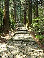 | 33°54′06″N 135°48′11″E | 3, 6 | |
Prefectural Historic Sites
As of 1 May 2019, one hundred and one Sites have been designated as being of prefectural importance.[4][7]
| Site | Municipality | Comments | Image | Coordinates | Type | Ref. |
|---|---|---|---|---|---|---|
| Ohara Tōdō Grave 小原桃洞墓 Ohara Tōdō haka | Wakayama | at Daion-ji (大恩寺) | 34°13′12″N 135°10′23″E | for all refs see | ||
| Kanō Morohira Grave 加納諸平墓 Kanō Morohira haka | Wakayama | 34°13′48″N 135°09′51″E | ||||
| Kawanabe Ōji Site 川辺王子跡 Kawanabe ōji ato | Wakayama | 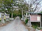 | 34°16′06″N 135°15′12″E | |||
| Kamayama Kofun 釜山古墳群 Kamayama kofun | Wakayama | 34°15′44″N 135°08′09″E | ||||
Municipal Historic Sites
As of 1 May 2019, zero Sites have been designated as being of municipal importance.[8]
gollark: The basics of service manager-ing aren't massively complex, so I suppose it'd be doable to implement your own.
gollark: It's a shame there wasn't some sort of middle ground where we got a reasonable service manager which didn't take over the entire system.
gollark: systemd does have problems, but at least unit files aren't init scripts...
gollark: I found out that its telnet interface was horribly secured, so I got root access and poked around.
gollark: Actually, come to think of it, I have that one ADSL modem/router which is unused which might be running BSD.
See also
References
- "Cultural Properties for Future Generations". Agency for Cultural Affairs. Retrieved 13 September 2019.
- 史跡名勝天然記念物 [Number of Monuments of Japan by Prefecture] (in Japanese). Agency for Cultural Affairs. 1 September 2019. Retrieved 13 September 2019.
- "Database of National Cultural Properties: 史跡名勝天然記念物 (史跡, 特別史跡 和歌山県 2県以上)" (in Japanese). Agency for Cultural Affairs. Archived from the original on 30 June 2019. Retrieved 13 September 2019.
- 指定文化財等件数 [Number of Cultural Properties] (in Japanese). Wakayama Prefecture. 1 April 2019. Retrieved 13 September 2019.
- "Sacred Sites and Pilgrimage Routes in the Kii Mountain Range". UNESCO. Retrieved 11 July 2012.
- "Kii Mountain Range (Japan)" (PDF). UNESCO. Retrieved 11 July 2012.
- 都道府県別指定等文化財件数(都道府県分) [Number of Prefectural Cultural Properties by Prefecture] (in Japanese). Agency for Cultural Affairs. 1 May 2019. Retrieved 13 September 2019.
- 都道府県別指定等文化財件数(市町村分) [Number of Municipal Cultural Properties by Prefecture] (in Japanese). Agency for Cultural Affairs. 1 May 2019. Retrieved 13 September 2019.
External links
- (in Japanese) Cultural Properties of Wakayama Prefecture
- (in Japanese) Wakayama Cultural Heritage Guide
This article is issued from Wikipedia. The text is licensed under Creative Commons - Attribution - Sharealike. Additional terms may apply for the media files.