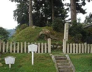
Ichirizuka
Ichirizuka (一里塚) are historic Japanese distance markers akin to milestones. Comprising a pair of earthen mounds (tsuka or zuka) covered in trees and flanking the road, they denoted the distance in ri (3.927 kilometres (2.440 mi)) to Nihonbashi, the "Bridge of Japan", erected in Edo in 1603.[3] Ichirizuka were encountered and described by Engelbert Kaempfer, c.1690: "serving as a milestone are two hills, facing each other, which are raised up on both sides of the road, and planted with one or more trees."[4][note 1]

_%E6%9D%B1%E6%B5%B7%E9%81%93%E4%BA%94%E6%8B%BE%E4%B8%89%E6%AC%A1%EF%BC%88%E7%8B%82%E6%AD%8C%E5%85%A5%E6%9D%B1%E6%B5%B7%E9%81%93%EF%BC%89.png)
Establishment
The Tokugawa shogunate established ichirizuka on the major roads in 1604, enabling calculation both of distance travelled and of the charge for transportation by kago or palanquin.[5] These mounds, to be maintained by "post stations and local villages", were one component of the developing road infrastructure, which also included bridges and ferries; post stations (both shukuba, and the more informal ai no shuku); and tea-houses (chaya).[6] However, the main aim was "official mobility, not recreational travelling": the movement of farmers and women was discouraged, and a system of passports and barriers (関所) maintained.[6] By marking the distance from Edo rather than Kyoto,
establishing a symbolic point of origin for all movements, the Tokugawa made of mile markers what they would later make of checkpoints: powerful reminders of the government's geopolitical ubiquity and efficacious tools in its appropriation of space.[3]
Ichirizuka were important enough to be found on the well-known "Proportional Map of the Tokaido" by printmaker Hishikawa Moronobu (d. 1694).[7] A traditional poem allegorically compares the ichirizuka that mark distance to the Kadomatsu marking the years of a person's life.[8]
Survival
With the modernization of Japan in the Meiji period, many of the mounds disappeared through road-widening and construction schemes, and the survival of both is now rare.[9][10] Of ichirizuka that are still extant, sixteen have been designated for protection as national Historic Sites.[11] Of the two within Tokyo, that at Nishigahara was once threatened by a road-widening project; a movement to save it led by industrialist Shibusawa Eiichi, the "father of Japanese capitalism", is commemorated in a monument beside what is now Hongō-dōri (本郷通り).[5][12] (35°44′50″N 139°44′28″E)
See also
| Wikimedia Commons has media related to Ichirizuka. |
Notes
- "Zu einem Meilenzeichen dienen zween gegen einander stehende Hugel, welche zu beiden Seiten des Weges aufge worfen und mit einem oder mehr Baumen bepflanzt sind" (Geschichte und Beschreibung von Japan)
References
- "垂井一里塚" [Tarui Ichirizuka]. Gifu Prefecture. Retrieved 3 July 2012.
- "Shöno (Station #46)". Honolulu Museum of Art. Retrieved 3 July 2012.
- Nenzi, Laura (2008). Excursions in Identity: Travel and the Intersection of Place, Gender, and Status in Edo Japan. University of Hawaii Press. pp. 21–22. ISBN 978-0-824-83117-2.
- "History of Japanese Roads". Ministry of Land, Infrastructure, Transport and Tourism. Archived from the original on 24 April 2009. Retrieved 3 July 2012.
- "Tokyo Cultural Properties Database: Nishigahara Ichirizuka". Tokyo Metropolitan Government. Retrieved 3 July 2012.
- Traganou, Jilly (2004). The Tōkaidō Road: Traveling and representation in Edo and Meiji Japan. Routledge. pp. 14–15. ISBN 0-415-31091-1.
- Vaporis, Constantine N. (2012). "Linking the Realm: The Gokaido Highway Network in Early Modern Japan (1603-1868)". In Susan E. Alcock (ed.). Highways, Byways, and Road Systems in the Pre-Modern World. John Bodel, Richard J.A. Talbert. John Wiley & Sons. pp. 90–105. ISBN 9780470674253. Retrieved 25 July 2012.
- Joly, Henry L. (1908). Legend in Japanese Art. London: John Lane. pp. 274–75. ISBN 9781440083921.
- "Historical and Cultural Monuments - Ano Ichirizuka". Toyoake City. Archived from the original on 8 August 2011. Retrieved 3 July 2012.
- "Tokyo Cultural Properties Database: Shimura Ichirizuka". Tokyo Metropolitan Government. Retrieved 3 July 2012.
- "Database of National Cultural Properties (search term: 一里塚)" (in Japanese). Agency for Cultural Affairs. Archived from the original on 4 December 2015. Retrieved 3 July 2012.
- "二本榎保存之碑" [Japanese Hackleberry Preservation Stele] (in Japanese). Kita Ward. Archived from the original on 25 May 2010. Retrieved 3 July 2012.