List of Historic Sites of Japan (Aomori)
National Historic Sites
As of 1 July 2019, twenty-two Sites have been designated as being of national significance (including one *Special Historic Site).[2][3][4]
| Site | Municipality | Comments | Image | Coordinates | Type | Ref. |
|---|---|---|---|---|---|---|
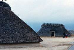
| *Sannai-Maruyama Site 三内丸山遺跡 Sannai-Maruyama iseki |
Aomori | submitted for inscription on the UNESCO World Heritage List as one of the Jōmon Archaeological Sites in Hokkaidō, Northern Tōhoku, and other regions[5][6] | 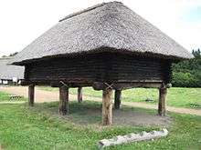 Sannai-Maruyama Site |
40°48′40″N 140°41′55″E | 1 | |
| Akōbō Kofun Cluster 阿光坊古墳群 Akōbō kofun-gun |
Oirase | Kofun period tumuli | 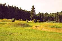 Akōbō Kofun Cluster |
40°36′34″N 141°22′36″E | 1 | |
| Kamegaoka Stone Age Site 亀ヶ岡石器時代遺跡 Kamegaoka sekki-jidai iseki |
Tsugaru | submitted for inscription on the UNESCO World Heritage List as one of the Jōmon Archaeological Sites in Hokkaidō, Northern Tōhoku, and other regions[5][6] | 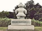 Kamegaoka Stone Age Site |
40°53′06″N 140°20′22″E | 1 | |
| Goshogawara Sue Pottery Kiln Site 五所川原須恵器窯跡 Goshogawara Sue-ki kama ato |
Goshogawara | Heian period kiln ruins | 40°45′31″N 140°32′49″E | 6 | ||
| Takayashikidate Site 高屋敷館遺跡 Takayashikidate iseki |
Aomori | Heian period settlement ruins | 40°44′13″N 140°35′04″E | 1 | ||
| Ne Castle ruins 根城跡 Ne-jō ato |
Hachinohe | Muromachi period | 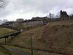 Ne Castle ruins |
40°30′22″N 141°27′39″E | 2 | |
| Shichinohe Castle ruins 七戸城跡 Shichinohe-jō ato |
Shichinohe | Muromachi period castle ruins | 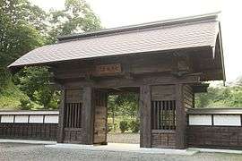 Shichinohe Castle ruins |
40°41′52″N 141°08′57″E | 2 | 96 |
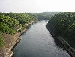
| Tosaminato ruins 十三湊遺跡 Tosa minato iseki |
Goshogawara | Muromachi period settlement ruins | 41°01′43″N 140°19′46″E | 1, 2, 6 | ||
| Komakino Site 小牧野遺跡 Komakino iseki |
Aomori | submitted for inscription on the UNESCO World Heritage List as one of the Jōmon Archaeological Sites in Hokkaidō, Northern Tōhoku, and other regions[5][6] | 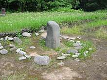 Komakino Site |
40°44′19″N 141°08′57″E | 1 | |
| Tareyanagi Site 垂柳遺跡 Tareyanagi iseki |
Inakadate | Yayoi period rice paddies[7] | 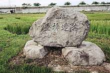 Tareyanagi Site |
40°37′59″N 140°33′57″E | 6 | |
| Korekawa Site 是川遺跡 Korekawa iseki |
Hachinohe | ICP excavated artefacts;[8] submitted for inscription on the UNESCO World Heritage List as one of the Jōmon Archaeological Sites in Hokkaidō, Northern Tōhoku, and other regions[5][6] | 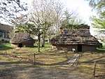 Korekawa Site |
40°28′25″N 141°29′28″E | 1 | |
| Shōjujidate Castle ruins 聖寿寺館跡 Shōjujitate ato |
Nanbu | Muromachi period castle ruins | 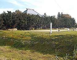 Shōjujitate ruins |
40°24′45″N 141°15′54″E | 2 | |
| Tangotai Kofun cluster 丹後平古墳群 Tangotai kofun |
Hachinohe | Kofun period tumuli | 40°28′52″N 141°28′01″E | 1 | ||
| Chōshichiyachi Shell Mound 長七谷地貝塚 Chōshichiyachi kaizuka |
Hachinohe | submitted for inscription on the UNESCO World Heritage List as one of the Jōmon Archaeological Sites in Hokkaidō, Northern Tōhoku, and other regions[5][6] | 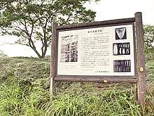 Chōshichiyachi Shell Mound |
40°34′19″N 141°27′32″E | 1 | |
| Tsugaru Clan Castle Sites 津軽氏城跡 Tsugaru-shi shiro ato |
Hirosaki, Ajigasawa | designation includes the sites of Tanesato Castle, Horikoshi Castle, and Hirosaki Castle (pictured) |  Tsuruga clan castles |
40°36′27″N 140°27′51″E | 2 | |
| Tagoyano Shell Mound 田小屋野貝塚 Tagoyano kaizuka |
Tsugaru | submitted for inscription on the UNESCO World Heritage List as one of the Jōmon Archaeological Sites in Hokkaidō, Northern Tōhoku, and other regions[5][6] | 40°53′17″N 140°20′21″E | 1 | ||
| Futatsumori Shell Mound 二ツ森貝塚 Futatsumori kaizuka |
Shichinohe | submitted for inscription on the UNESCO World Heritage List as one of the Jōmon Archaeological Sites in Hokkaidō, Northern Tōhoku, and other regions[5][6] | 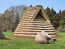 Futatsumori Shell Mound |
40°44′54″N 141°13′47″E | 1 | |
| Hamashiriya Shell Mound 浜尻屋貝塚 Hamashiriya kaizuka |
Higashidōri | Muromachi period shell middens | 41°24′38″N 141°27′31″E | 1 | ||
| Namioka Castle ruins 浪岡城跡 Namioka-jō ato |
Aomori | Muromachi period castle ruins | 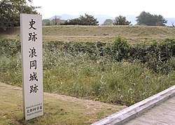 Namioka Castle ruins |
40°43′04″N 140°36′17″E | 2 | |
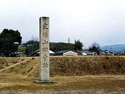
| Ōmori Katsuyama Site 大森勝山遺跡 Ōmori Katsuyama iseki |
Hirosaki | Jōmon period stone circle | 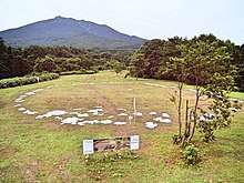 Ōmori Katsuyama Site |
40°36′11″N 140°27′50″E | 1 | |
| Ōdai Yamamoto I Site 大平山元遺跡 Ōdai Yamamoto iseki |
Sotogahama | submitted for inscription on the UNESCO World Heritage List as one of the Jōmon Archaeological Sites in Hokkaidō, Northern Tōhoku, and other regions[5][6] |  Odai Yamamoto I Site |
41°04′02″N 140°33′18″E | 1 | |
| Sannobō Site 山王坊遺跡 Sannobō iseki | Goshogawara | Muromachi period temple ruins |  | 41°03′55″N 140°22′05″E | 3 |
Prefectural Historic Sites
As of 26 March 2019, a further twenty Sites have been designated as being of prefectural importance.[4][9]
| Site | Municipality | Comments | Image | Coordinates | Type | Ref. |
|---|---|---|---|---|---|---|
| Seki Old Stelai 関の古碑群 Seki no ko-hi-gun | Fukaura | forty-two C14 memorial stelai | 40°44′23″N 140°06′14″E | |||
| Hachinohe Nanbu clan cemetery 八戸南部家墓所 Hachinohe nanbu-ke bosho | Hachinohe | 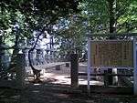 | 40°30′10″N 141°29′20″E | |||
| Karauma Stele 唐馬の碑 Karauma no hi | Sannohe | 40°23′45″N 141°15′50″E | ||||
| Tenma Ichirizuka 一里塚 ichirizuka | Hachinohe | in Tenma; one mound survives | 40°28′33″N 141°30′47″E | |||
| Tairakubo Ichirizuka 一里塚 ichirizuka | Towada | in Tairakubo; both mounds survive | 40°34′29″N 141°15′53″E | |||
| Ikenotani Ichirizuka 一里塚 ichirizuka | Towada | in Ikenotai; both mounds survive | 40°40′34″N 141°10′29″E | |||
| Bonozuka Ichirizuka 一里塚 ichirizuka | Noheji | in Bonozuka; both mounds survive | 40°51′33″N 141°07′36″E | |||
| Sotsukozawa Ichirizuka 一里塚 ichirizuka | Shichinohe | in Sotsukozawa; both mounds survive | 40°47′00″N 141°10′21″E | |||
| Morinokami Ichirizuka 一里塚 ichirizuka | Shichinohe | in Morinokami; both mounds survive | 40°44′45″N 141°09′24″E | |||
| Nagakubo Ichirizuka 一里塚 ichirizuka | Hachinohe | in Nagakubo; one mound survives | 40°26′14″N 141°27′48″E | |||
| Shinden Ichirizuka 一里塚 ichirizuka | Hachinohe | in Shinden; both mounds survive | 40°24′34″N 141°26′21″E | |||
| Sunakozaki Ichirizuka 一里塚 ichirizuka | Hachinohe | in Sunakozaki; both mounds survive | 40°22′36″N 141°25′01″E | |||
| Yahatazaki Site 八幡崎遺跡 Yahatazaki iseki | Hirakawa | 40°37′03″N 140°32′07″E | ||||
| Hankyōzuka 藩境塚 Hankyōzuka | Hiranai/Noheji | four mounds | 40°53′14″N 141°04′57″E | |||
| Battle of Noheji cemetery 野辺地戦争戦死者の墓所 Noheji-sensō senshisha no bosho | Noheji | 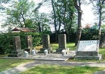 | 40°52′16″N 141°06′34″E | |||
| Nakano Ichirizuka 一里塚 ichirizuka | Sannohe | in Nakano; both mounds survive | 40°21′01″N 141°15′43″E | |||
| Tonai Mass Graves and Memorial Stele 斗内千人塚 墳丘 供養塔 Tonai senninzuka funkyū kuyōtō | Sannohe | from the great famine of 1783-4 (天明の大飢饉) | 40°21′34″N 141°12′25″E | |||
| Memorial Stele and Platform for the Starved 餓死萬霊等供養塔及び戒壇石 Gashi banrei-tō kuyōtō oyobi kaidanseki | Hachinohe | from the 1780s famine; in Teranoue | 40°29′55″N 141°31′35″E | |||
| Nakasato Castle ruins 中里城遺跡 Nakasato-jō iseki | Nakadomari | 40°58′13″N 140°26′30″E | ||||
| Tairadate Battery ruins 平舘台場跡 Tairadate daiba ato | Sotogahama | 41°10′28″N 140°38′34″E | ||||
Municipal Historic Sites
As of 1 May 2018, a further ninety-two Sites have been designated as being of municipal importance.[10]
gollark: It's not a *crime* to meddle with finances to be taxed somewhere else.
gollark: Well, I just think "hmm, do I agree with this or not", then I click something between "strongly agree" and "strongly disagree".
gollark: The thing with raising taxes on rich people is that really rich ones can just switch countries or evade taxes.
gollark: * a private healthcare system
gollark: I personally support private system, but not through the US's horrible, horrible system, and UBI so people can reasonably pay for it.
See also
References
- "Cultural Properties for Future Generations". Agency for Cultural Affairs. Retrieved 19 July 2019.
- 史跡名勝天然記念物 [Number of Monuments of Japan by Prefecture] (in Japanese). Agency for Cultural Affairs. 1 July 2019. Retrieved 19 July 2019.
- "Database of National Cultural Properties: 史跡名勝天然記念物 (史跡, 特別史跡 北海道)" (in Japanese). Agency for Cultural Affairs. Archived from the original on 30 June 2019. Retrieved 19 July 2019.
- 国・県指定文化財一覧 [List of National and Prefectural Cultural Properties] (in Japanese). Aomori Prefecture. 26 March 2019. Retrieved 19 July 2019.
- "Jômon Archaeological Sites in Hokkaidô, Northern Tôhoku, and other regions". UNESCO. Retrieved 13 June 2012.
- 「北海道・北東北を中心とした縄文遺跡群」の世界文化遺産登録をめざして [Towards World Heritage Inscription of "Jōmon Archaeological Sites in Hokkaidō, Northern Tōhoku, and other regions"] (in Japanese). Hokkaidō Government Board of Education. Archived from the original on 8 May 2013. Retrieved 13 June 2012.
- 垂柳遺跡 [Tareyanagi Site] (in Japanese). Aomori Prefecture. Retrieved 13 June 2012.
- 陸奥国是川遺跡出土品 [Excavated Artifacts from the Korekawa Site] (in Japanese). Agency for Cultural Affairs. Retrieved 13 June 2012.
- 都道府県別指定等文化財件数(都道府県分) [Number of Prefectural Cultural Properties by Prefecture] (in Japanese). Agency for Cultural Affairs. 1 May 2018. Retrieved 15 June 2019.
- 都道府県別指定等文化財件数(市町村分) [Number of Municipal Cultural Properties by Prefecture] (in Japanese). Agency for Cultural Affairs. 1 May 2018. Retrieved 19 July 2019.
External links
| Wikimedia Commons has media related to National historic sites in Aomori prefecture. |
- (in Japanese) Cultural Properties of Aomori Prefecture
This article is issued from Wikipedia. The text is licensed under Creative Commons - Attribution - Sharealike. Additional terms may apply for the media files.