Yoshino, Nara
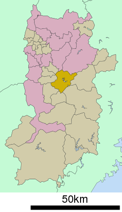
Yoshino (吉野町, Yoshino-chō) is a town located in Yoshino District, Nara Prefecture, Japan.
Yoshino 吉野町 | |
|---|---|
Town | |
Flag | |
 Location of Yoshino in Nara Prefecture | |
 Yoshino Location in Japan | |
| Coordinates: 34°24′N 135°51′E | |
| Country | Japan |
| Region | Kansai |
| Prefecture | Nara Prefecture |
| District | Yoshino |
| Area | |
| • Total | 95.96 km2 (37.05 sq mi) |
| Population (February 1, 2020) | |
| • Total | 6,337 |
| • Density | 66.3/km2 (172/sq mi) |
| Time zone | UTC+9 (JST) |
| City hall address | 80-1 Ōaza Kamiichi, Yoshino-machi, Yoshino-gun, Nara-ken 639-3192 |
| Website | www |
As of September 1, 2007, the town had an estimated population of 6,337 and a density of 66.3 per square kilometre (172/sq mi). The total area was 95.65 km2 (36.93 sq mi).
Geography
The town of Yoshino is located in the northern portion of Yoshino District. Most of the area is mountainous, but the section along the Yoshino River is somewhat flatter and contains most of the town's roads, train tracks and houses.
- Mountains: Yoshino Mountain
- Rivers: Yoshino River
- Lakes: Lake Tsuburo
The most well-known area within the town is Yoshino Mountain, famous for its many thousands of sakura trees; much poetry has been written on the subject by several famous authors, including Chiyo and Uejima Onitsura.[1] These flowering cherry trees were planted in four groves at different altitudes, in part so that the trees would be visible coming into bloom at different times in the spring. An account of Yoshino written in about 1714 explained that, on their climb to the top, travelers would be able to enjoy the lower 1,000 cherry trees at the base, the middle 1,000 on the way, the upper 1,000 toward the top, and the 1,000 in the precincts of the inner shrine at the top.[2]
Sacred For adherents of Shugendo, Yoshino Mountain is the traditional beginning of the Mount Ōmine pilgrimage trail (part of the Omine-Okugake Trail), although nowadays many hikers begin and end their trek in the Dorogawa district of Tenkawa Village.
Industry
Lumber
The town of Yoshino produces a wide variety of wood-based goods made from lumber harvested from the local forest land. Most of the forest within the Yoshino area is artificial, consisting of red cedar and cypress trees that have been planted and harvested in cycles for 500 years.[3] The Yoshino River served in past times as a means of transportation for the lumber harvested in the region.
Paper
The Kuzu district of Yoshino has a long history of traditional Japanese washi paper production. According to a local story, Prince Oama (later to become Emperor Tenmu), taught the residents of Kuzu the process of making washi in the 7th century.[4]
Surrounding municipalities
Notable places
- Yoshino-Kumano National Park
- Yoshino Mountain
- Yoshino Shrine
- Miyataki (district)
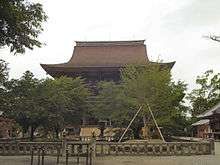
- Kinpusen-ji
- Yoshimizu Shrine
- Sakuramotobō
- Yoshinomikumari Shrine
- Nyoirin-ji
- Sakuragi Shrine
- Ryumon-no-taki (waterfall)
- Takataki (waterfall)
- Kinpu Shrine
- Saigyo-an Hermitage
References
- Gill, Robin (2006). Cherry Blossom Epiphany: The Poetry and Philosophy of a Flowering Tree (1st ed.). Paraverse Press. pp. 632–678 of 740. ISBN 0974261866.
- Kaibara Ekiken. (1714). Yoshinoyama syokeizu Archived March 5, 2008, at the Wayback Machine; Stokes, Henry Scott. Cherry Blossom Time Puts Japan at Ease," New York Times. March 6, 1983.
- 吉野中央森林組合. 吉野中央森林組合 (in Japanese). Retrieved 2018-07-23.
- 国栖の里観光協会トップページ. 国栖の里観光協会 (in Japanese). Retrieved 2018-07-23.
| Wikimedia Commons has media related to Yoshino, Nara. |
External links
- Yoshino official website (in Japanese)
- Kansai Digital Archives ...Images of Yoshino-cho
- National Archives of Japan Yoshinoyama syokeizu, illustrated scroll describing Mt. Yoshino, text by Kaibara Ekiken (circa 1714)
- Japan-guide.com Yoshino at Japan Guide


- Nyoirin-ji official website (in Japanese)

