List of Historic Sites of Japan (Toyama)
National Historic Sites
As of 1 August 2019, twenty-one Sites have been designated as being of national significance, including the Kaga Domain Maeda Clan Graves and Kaetsu Territory Castle Sites and Roads, which span the prefectural borders with Ishikawa.[2][3][4]
| Site | Municipality | Comments | Image | Coordinates | Type | Ref. |
|---|---|---|---|---|---|---|
| Jōbenoma Site じょうべのま遺跡 Jōbenoma iseki |
Nyūzen | Heian shōen ruins | 36°57′15″N 137°29′42″E | 6 | 968 | |
| Yasuda Castle Site 安田城跡 Yasuda-jō ato |
Toyama | Sengoku period castle ruins |  Yasuda Castle Site |
36°40′48″N 137°09′38″E | 2 | 969 |
| Etchū Gokayama Suganuma Hamlet 越中五箇山菅沼集落 Etchū Gokayama Suganuma shūraku |
Nanto | forms part of the UNESCO World Heritage Site Historic Villages of Shirakawa-gō and Gokayama[5] | 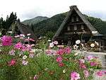 Etchū Gokayama Suganuma Hamlet |
36°24′15″N 136°53′12″E | 6 | 962 |
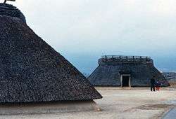
| Etchū Gokayama Ainokura Hamlet 越中五箇山相倉集落 Etchū Gokayama Ainokura shūraku |
Nanto | forms part of the UNESCO World Heritage Site Historic Villages of Shirakawa-gō and Gokayama[5] |  Etchū Gokayama Ainokura Hamlet |
36°25′33″N 136°56′07″E | 6 | 961 |
| Ōzuka-Senbōyama Sites 王塚・千坊山遺跡群 Ōzuka-Senbōyama iseki-gun |
Toyama | 36°39′38″N 137°07′01″E | 1 | 959 | ||
| Kushidashin Site 串田新遺跡 Kushidashin iseki |
Imizu | Jomon period settlement | 36°41′21″N 137°02′29″E | 1 | 967 | |
| Takase Site 高瀬遺跡 Takase iseki |
Nanto | early Heian period shōen ruins[6] | 36°33′53″N 136°56′58″E | 6 | 963 | |
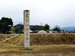
| Sakuradani Kofun 桜谷古墳 Sakuradani kofun |
Takaoka | -2%2C_entrance.jpg) Sakuradani Kofun |
36°49′00″N 137°01′56″E | 1 | 952 | |
| Kosugimaruyama Site 小杉丸山遺跡 Kosugimaruyama iseki |
Imizu | Asuka period kilns | 36°41′47″N 137°03′55″E | 1 | 972 | |
| Kamiichi Kurokawa Sites 上市黒川遺跡群 Kamiichi Kurokawa iseki-gun |
Kamiichi | designation includes the sites of the Ennenjiyama Sutra Mound (円念寺山経塚), Kurokawa Ueyama Graves (黒川上山墓跡), and Shingō-ji (伝真興寺跡) | 36°42′53″N 137°24′09″E | 3, 7 | 00003468 | |
| Masuyama Castle Site 増山城跡 Masuyama-jō ato |
Tonami | Sengoku period castle ruins | 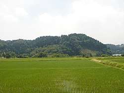 Masuyama Castle Site |
36°39′08″N 137°02′36″E | 2 | 00003642 |
| Ōiwa Nissekiji Stone Buddhas 大岩日石寺石仏 Ōiwa Nissekiji sekibutsu |
Kamiichi | Nara period bas-relief carvings |  Ōiwa Nissekiji Stone Buddhas |
36°39′44″N 137°23′28″E | 3 | 951 |
| Ōzakai Cave Dwelling Site 大境洞窟住居跡 Ōzakai dōkutsu jūkyo ato |
Himi |  Ōzakai Cave Dwelling Site |
36°55′22″N 137°01′49″E | 1 | 945 | |
| Asahi Shell Mound 朝日貝塚 Asahi kaizuka |
Himi | Jomon period shell midden |  Asahi Shell Mound |
36°50′55″N 136°59′04″E | 1 | 944 |
| Sugusaka Site 直坂遺跡 Sugusaka iseki |
Toyama | Japanese Paleolithic settlement | 36°33′35″N 137°13′12″E | 1 | 970 | |
| Fudōdō Site 不動堂遺跡 Fudōdō iseki |
Asahi | Jōmon period settlement | 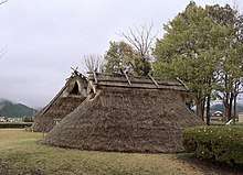 Fudōdō Site |
36°55′15″N 137°33′13″E | 1 | 966 |
| Kitadai Site 北代遺跡 Kitadai iseki |
Toyama | Jōmon period settlement | 36°43′03″N 137°11′10″E | 1 | 971 | |
| Yanaidanu-no-Oyama Kofun 柳田布尾山古墳 Yanaidanu-no-Oyama kofun |
Himi |  Yanaidanu-no-Oyama Kofun |
36°49′24″N 136°59′27″E | 1 | 3278 | |
| Kaga Domain Maeda Clan Graves 加賀藩主前田家墓所 Kaga-han-shu Maeda-ke bosho |
Takaoka | designation includes an area of Kanazawa in Ishikawa Prefecture |  Kaga Domain Maeda Clan Graves |
36°44′15″N 137°01′23″E | 7 | 00003621 |
| Kaetsu Territory Castle Sites and Roads 加越国境城跡群及び道 切山城跡 松根城跡 小原越 Kaetsu-kuni-zakai shiro ato-gun oyobi michi Kiriyama-jō ato Matsune-jō ato Ohara-goe |
Oyabe | designation includes the sites of Kiriyama Castle, Matsune Castle, and Ohara Pass and an area of Kanazawa in Ishikawa Prefecture | 36°36′58″N 136°47′00″E | 6 | 00003879 | |
| Takaoka Castle Site 高岡城跡 Takaoka-jō ato | Takaoka |  | 36°44′57″N 137°01′14″E | 高岡城跡 文化遺産オンライン |
Prefectural Historic Sites
As of 1 May 2019, thirty Sites have been designated as being of prefectural importance.[7][8]
| Site | Municipality | Comments | Image | Coordinates | Type | Ref. |
|---|---|---|---|---|---|---|
| Ao Castle Site 阿尾城跡 Ao-jō ato | Himi |  | 36°52′48″N 136°59′27″E | |||
| Sakai Ichirizuka 境一里塚 Sakai ichirizuka | Asahi | 36°58′35″N 137°37′28″E | ||||
| Miyazaki Castle Site 宮崎城跡 Miyazaki-jō ato | Himi | 36°57′47″N 137°35′08″E | ||||
| Chigozuka 稚児塚 Chigozuka | Tateyama |  | 36°41′34″N 137°19′08″E | |||
| Jōgahira Cave Tombs 城ガ平横穴古墳 Jōgahira ōketsu kofun-gun | Takaoka | 36°44′28″N 136°55′39″E | ||||
| Ōzuka Kofun 大塚古墳 Ōzuka kofun | Imizu | 36°42′03″N 137°03′26″E | ||||
| Sakuratōge Site 桜峠遺跡 Sakuratōge iseki | Uozu | 36°49′29″N 137°28′25″E | ||||
| Matuskura Castle Site 松倉城跡 Matuskura-jō ato | Uozu |  | 36°45′44″N 137°26′27″E | |||
| Kitano Stone Buddha Niche 北野の石龕 Kitano no sekigan | Kurobe | 36°53′30″N 137°26′54″E | ||||
| Gorintō 嘉暦四歳銘五輪石塔 Karyaku yonsai mei gorin sekitō | Kurobe | inscribed Karyaku 4 (1329) | 36°53′19″N 137°25′56″E | |||
| Kareisawa Stone Buddhas 嘉例沢の石仏 Kareisawa sekibutsu | Kurobe | 36°49′42″N 137°32′04″E | ||||
| Etchū Kokubun-ji Site 越中国分寺跡 Etchū Kokubunji ato | Takaoka | provincial temple of Etchū Province |  | 36°47′52″N 137°02′57″E | ||
| Chokushizuka 勅使塚 Chokushizuka | Toyama | 36°39′38″N 137°07′01″E | ||||
| Sakai Barrier Site 境関跡 Sakai seki ato | Asahi |  | 36°58′37″N 137°37′33″E | |||
| Inotani Barrier Site 猪谷関跡 Inotani seki ato | Toyama |  | 36°28′17″N 137°14′22″E | |||
| Kifune Castle Site 木舟城跡 Kifune-jō ato | Takaoka |  | 36°41′18″N 136°54′50″E | |||
| Ikuji Battery 生地台場 Ikuji daiba | Kurobe |  | 36°53′57″N 137°24′39″E | |||
| Miyanaga Jūzaemon Grave 宮永十佐エ門の墓 Miyanaga Jūzaemon no haka | Oyabe | 36°36′16″N 136°53′40″E | ||||
| Zuiryū-ji Stone Tombs 瑞龍寺の石廟 Zuiryūji no sekibyō | Takaoka |  | 36°44′08″N 137°00′38″E | |||
| Aimotoshin Site 愛本新遺跡 Aimotoshin iseki | Kurobe | 36°53′14″N 137°32′31″E | ||||
| Hongō Site 本江遺跡 Hongō iseki | Namerikawa | 36°43′38″N 137°23′05″E | ||||
| Takase Site (Anada District) 高瀬遺跡 (穴田地区) Takase iseki (Anada chiku) | Nanto | 36°33′54″N 136°56′58″E | ||||
| Hamayama Jewelry Workshop 浜山玉つくり遺跡 Hamayama tama-tsukuri iseki | Asahi | Kofun-period workshop for magatama, cylindrical beads, and other jewels[9] | 36°58′13″N 137°36′06″E | |||
| Nakayamaminami Site 中山南遺跡 Nakayamaminami iseki | Imizu | 36°42′19″N 137°06′32″E | ||||
| Mizukamitani Site 水上谷遺跡 Mizukamitani iseki | Imizu | 36°39′56″N 137°04′03″E | ||||
| Kanakusa No.1 Kiln Site 金草第一古窯跡 Kanakusa daiichi furu kama ato | Toyama | 36°41′51″N 137°09′21″E | ||||
| Higashi-Kuromaki-Ueno Site 東黒牧上野遺跡 Higashi-Kuromaki-Ueno iseki | Toyama | 36°36′09″N 137°16′40″E | ||||
| Kakoiyama Site 囲山遺跡 Kakoiyama iseki | Imizu | 36°42′33″N 137°05′24″E | ||||
| Wakamiya Kofun 若宮古墳 Wakamiya kofun | Oyabe | 36°39′52″N 136°51′06″E | ||||
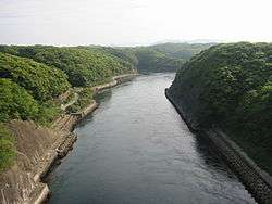
| Shōmyō Falls Basin 称名滝とその流域 Shōmyō-daki to sono ryūiki | Tateyama | the falls are a national Place of Scenic Beauty and Natural Monument and a locus of Shugendō practice[10][11] | 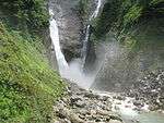 | 36°34′33″N 137°31′36″E | ||
Municipal Historic Sites
As of 1 May 2019, a further one hundred and eighty-five Sites have been designated as being of municipal importance.[12]
Registered Historic Sites
As of 1 July 2019, one Monument has been registered (as opposed to designated) as an Historic Site at a national level.[13]
| Place | Municipality | Comments | Image | Coordinates | Type | Ref. |
|---|---|---|---|---|---|---|
| Tateyama Sabō Erosion Control Works Railway 立山砂防工事専用軌道 Tateyama sabō kōji sen-yō kidō | Tateyama | 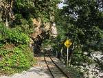 | 36°33′55″N 137°29′20″E | |||
See also
| Wikimedia Commons has media related to National historic sites in Toyama prefecture. |
| Wikimedia Commons has media related to Prefectural Historic Sites in Toyama Prefecture. |
References
- "Cultural Properties for Future Generations". Agency for Cultural Affairs. Retrieved 30 August 2019.
- 史跡名勝天然記念物 [Number of Monuments of Japan by Prefecture] (in Japanese). Agency for Cultural Affairs. 1 August 2019. Retrieved 30 August 2019.
- "Database of National Cultural Properties: 史跡名勝天然記念物 (史跡, 特別史跡 富山県 2県以上)" (in Japanese). Agency for Cultural Affairs. Archived from the original on 30 June 2019. Retrieved 30 August 2019.
- 富山県指定文化財 [Cultural Properties of Toyama Prefecture] (in Japanese). Toyama Prefecture. 31 March 2016. Retrieved 30 August 2019.
- "Historic Villages of Shirakawa-go and Gokayama". UNESCO. Retrieved 19 June 2012.
- 史跡公園「高瀬遺跡」 [Historic Park "Takase Site"] (in Japanese). Nanto City. Retrieved 19 June 2012.
- 都道府県別指定等文化財件数(都道府県分) [Number of Prefectural Cultural Properties by Prefecture] (in Japanese). Agency for Cultural Affairs. 1 May 2019. Retrieved 30 August 2019.
- 富山県指定文化財 [Toyama Prefectural Cultural Properties] (in Japanese). 2018. Retrieved 30 August 2019.
- 玉つくりの遺跡 [Jewelry Workshop Site] (in Japanese). Toyama Prefecture. Retrieved 29 June 2012.
- 称名滝 [Shōmyō Falls] (in Japanese). Agency for Cultural Affairs. Retrieved 29 June 2012.
- 称名滝とその流域 [Shōmyō Falls Basin] (in Japanese). MLIT Hokuriku Regional Development Bureau. Archived from the original on 6 January 2013. Retrieved 29 June 2012.
- 都道府県別指定等文化財件数(市町村分) [Number of Municipal Cultural Properties by Prefecture] (in Japanese). Agency for Cultural Affairs. 1 May 2019. Retrieved 30 August 2019.
- 登録文化財 [Number of Registered Cultural Properties by Prefecture] (in Japanese). Agency for Cultural Affairs. 1 July 2019. Retrieved 30 August 2019.
External links
- Historic Sites of Toyama Prefecture (in Japanese)
This article is issued from Wikipedia. The text is licensed under Creative Commons - Attribution - Sharealike. Additional terms may apply for the media files.