Hilgert
Hilgert in the Kannenbäckerland is an Ortsgemeinde – a community belonging to a Verbandsgemeinde – in the Westerwaldkreis in Rhineland-Palatinate, Germany.
Hilgert | |
|---|---|
 | |
 Coat of arms | |
Location of Hilgert within Westerwaldkreis district 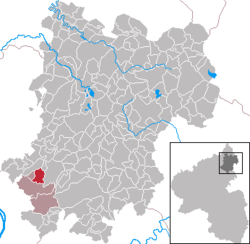 | |
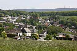
 Hilgert  Hilgert | |
| Coordinates: 50°27′21″N 7°41′20″E | |
| Country | Germany |
| State | Rhineland-Palatinate |
| District | Westerwaldkreis |
| Municipal assoc. | Höhr-Grenzhausen |
| Government | |
| • Mayor | Uwe Schmidt (SPD) |
| Area | |
| • Total | 4.57 km2 (1.76 sq mi) |
| Elevation | 300 m (1,000 ft) |
| Population (2018-12-31)[1] | |
| • Total | 1,515 |
| • Density | 330/km2 (860/sq mi) |
| Time zone | CET/CEST (UTC+1/+2) |
| Postal codes | 56206 |
| Dialling codes | 02624 |
| Vehicle registration | WW |
| Website | www.gemeinde-hilgert.de |
Geography
Location
Hilgert lies roughly 13 km from Koblenz on the edge of the Nassau Nature Park. The community belongs to the Verbandsgemeinde of Höhr-Grenzhausen, a kind of collective municipality.
History
Hilgert was first mentioned in documents dating to 1340.
Politics
Community council
The council is made up of 17 council members, including the extraofficial mayor (Bürgermeister), who were elected in a municipal election on 7 June 2009.
| CDU | SPD | FWG | Total | |
| 2004 | 6 | 6 | 4 | 16 seats |
Economy and infrastructure
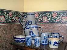
Westerwald ceramics
Transport
The A 48 with its Höhr-Grenzhausen interchange (AS 12) lies right near the municipal area, 3 km away. There is no rail connection, only an hourly bus to Koblenz.
gollark: Also water.
gollark: But how am I meant to get an internet connection then, hmmm?
gollark: I do not live anywhere with very good jobs in any fields I like.
gollark: The system is weird and half government-funded, though. There's a cap of £9250/year but most universities just charge right up to the limit.
gollark: Well, yes, you do pay here. In pretty much all cases you will pay anyway, just indirectly.
References
- "Bevölkerungsstand 2018 - Gemeindeebene". Statistisches Landesamt Rheinland-Pfalz (in German). 2019.
This article is issued from Wikipedia. The text is licensed under Creative Commons - Attribution - Sharealike. Additional terms may apply for the media files.