Neunkirchen, Westerwaldkreis
Neunkirchen (German: [ˈnɔɪ̯nˌkɪʁçn̩] (![]()
Neunkirchen | |
|---|---|
.png) Coat of arms | |
Location of Neunkirchen within Westerwaldkreis district 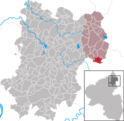 | |
 Neunkirchen  Neunkirchen | |
| Coordinates: 50°32′49″N 8°6′14″E | |
| Country | Germany |
| State | Rhineland-Palatinate |
| District | Westerwaldkreis |
| Municipal assoc. | Rennerod |
| Government | |
| • Mayor | Günter Göbel |
| Area | |
| • Total | 6.61 km2 (2.55 sq mi) |
| Elevation | 320 m (1,050 ft) |
| Population (2018-12-31)[1] | |
| • Total | 547 |
| • Density | 83/km2 (210/sq mi) |
| Time zone | CET/CEST (UTC+1/+2) |
| Postal codes | 56479 |
| Dialling codes | 06436 |
| Vehicle registration | WW |
| Website | www.rennerod.de |
Geography
Location
The community lies in the Westerwald between the towns of Siegen (38 km to the north), Wetzlar (28 km to the east) and Limburg an der Lahn (19 km to the south). Neunkirchen is the southernmost place belonging to the Verbandsgemeinde of Rennerod – a kind of collective municipality – whose seat is in the like-named town.
gollark: Put in an OpenOS floppy disk.
gollark: My base!
gollark: No idea. Currently I'm playing Minecraft, trying to reconfigure my phone after accidentally bricking it slightly, and checking this.
gollark: Well, if you want me to do it all for you, I'm too busy right now.
gollark: Have you written any which doesn't work or whatever?
References
- "Bevölkerungsstand 2018 - Gemeindeebene". Statistisches Landesamt Rheinland-Pfalz (in German). 2019.
| Authority control |
|
|---|
This article is issued from Wikipedia. The text is licensed under Creative Commons - Attribution - Sharealike. Additional terms may apply for the media files.