Giesenhausen
Giesenhausen is an Ortsgemeinde – a community belonging to a Verbandsgemeinde – in the Westerwaldkreis in Rhineland-Palatinate, Germany.
Giesenhausen | |
|---|---|
 | |
 Coat of arms | |
Location of Giesenhausen within Westerwaldkreis district 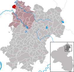 | |
 Giesenhausen  Giesenhausen | |
| Coordinates: 50°42′13″N 7°43′23″E | |
| Country | Germany |
| State | Rhineland-Palatinate |
| District | Westerwaldkreis |
| Municipal assoc. | Hachenburg |
| Government | |
| • Mayor | Michael Meier |
| Area | |
| • Total | 4.88 km2 (1.88 sq mi) |
| Elevation | 300 m (1,000 ft) |
| Population (2018-12-31)[1] | |
| • Total | 316 |
| • Density | 65/km2 (170/sq mi) |
| Time zone | CET/CEST (UTC+1/+2) |
| Postal codes | 57612 |
| Dialling codes | 02688 |
| Vehicle registration | WW |
| Website | giesenhausen.de |
Geography
Location
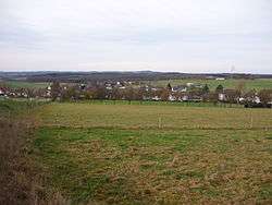
The community lies in the Westerwald between Limburg and Siegen, on the edge of the Kroppach Switzerland. The agriculturally oriented residential community of Giesenhausen belongs to the Verbandsgemeinde of Hachenburg, a kind of collective municipality. Its seat is in the like-named town.
History
In 1311, Giesenhausen had its first documentary mention.
Politics
Community council
The council is made up of 8 council members who were elected in a majority vote in a municipal election in May 2014.
Regular events
The Maifest (“May Festival”), held yearly on 30 April at the grill lodge and organized by the Maijugend (“May Youth”) is a highlight in community life.
Economy and infrastructure
Transport
South of the community runs Bundesstraße 414 leading from Hohenroth to Hachenburg. The nearest Autobahn interchanges are in Siegen, Wilnsdorf and Herborn on the A 45 (Dortmund–Aschaffenburg), some 25 km away. The nearest InterCityExpress stop is the railway station at Montabaur on the Cologne-Frankfurt high-speed rail line.
References
- "Bevölkerungsstand 2018 - Gemeindeebene". Statistisches Landesamt Rheinland-Pfalz (in German). 2019.
External links
- Official Homepage of Giesenhausen (in German)
- Giesenhausen in the collective municipality’s Web pages (in German)
- Giesenhausen at swr.de (in German)
| Authority control |
|
|---|