King George Boulevard
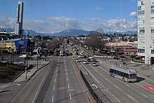
King George Boulevard is a major arterial road in Surrey, British Columbia, Canada. The 26 km (16 mi) route begins in the north at the south end of the Pattullo Bridge, a crossing of the Fraser River that connects Surrey with New Westminster; and runs generally southeast to connect with Highway 99, 3 km north of the Peace Arch Border Crossing with the United States. The majority of the route varies from four to six lanes, and some sections in the north run parallel to the Expo Line, which has two adjacent SkyTrain stations: Scott Road station in South Westminster, and King George station in the Surrey City Centre district.
 Looking north from an Expo Line train | |
| Former name(s) | King George Highway |
|---|---|
| Part of | |
| Maintained by | TransLink |
| Length | 26 km[1] (16 mi) |
| Location | Surrey |
| South end | 8th Avenue |
| Major junctions | Fraser Highway |
| North end | Pattullo Bridge |
History
Opened in 1940, the route was originally named King George Highway in honour of the royal visit of King George VI the previous year. The name was changed to King George Boulevard in 2009 "to project an image of a modern, safe, walkable and livable City Centre community",[2] given that portions of the corridor have had a reputation for being dangerous and having a high incidence of criminal activity.
The corridor was a major portion of Highway 99A, which continued northwest over the Pattullo Bridge, joining with Highway 99 in downtown Vancouver. Highway 99A was decommissioned in 2006.
Route description
King George Boulevard begins at the south end of the Pattullo Bridge and runs through the Bridgeview neighbourhood of north Surrey, on the south bank of the Fraser River. It runs east and then south through the populous town centres of Whalley and Newton before heading through the more suburban and rural Panorama Ridge neighbourhood. In South Surrey, a crossing over Highway 99 which has a northbound ramp to Richmond and Vancouver, and southbound ramp to Seattle. From there, the route assumes a south-eastward orientation, running adjacent to the larger highway and through the more urban neighbourhood of Sunnyside, before emerging onto Highway 99 southbound at 8th Ave.
References
- Google (December 28, 2016). "King George Blvd in Greater Vancouver" (Map). Google Maps. Google. Retrieved December 28, 2016.
- Corporate Report No: R207 (PDF) (Report). City of Surrey. November 16, 2009.