Forest Lake, New Zealand
Forest Lake is a suburb of Hamilton in New Zealand and was added to from around the 1930s. It is centred around Forest Lake Road, which is used by around 10,000 vehicles a day.[1]
Forest Lake | |
|---|---|
Suburb | |
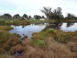 Lake Rotokaeo and Minogue Park playground in 2017 | |
| Country | New Zealand |
| Local authority | Hamilton, New Zealand |
| Electoral ward | Hamilton West |
| Established | 1914area= |
| Te Rapa | St Andrews | |
| Rotokauri |
|
Beerescourt |
| Nawton | Maeroa | Whitiora |
For quite a long time there was swamp in a large part and this has now been drained but Lake Rotokaeo remains and the ground remains quite damp in parts.
Forest Lake is named after the forest that once surrounded Rotokaeo.[2] It has no precise boundary, but is in the southern part of Te Rapa, north of Maeroa and west of Beerescourt, census area units.[3]
History
Until the 1863 invasion of the Waikato, the area lay between the pās of Mangaharakeke and Kirikiriroa on the lands of Ngāti Wairere.[4]
After confiscation, farms were established on 200 ha (490 acres) from Lake Rotoroa to Forest Lake Rd, owned by Thomas Jolly, and 162 ha (400 acres), to the north, owned by John Carey, a doctor with the 4th Waikato Regiment.[5]
The first housing was the Laurenson Settlement, on Forest Lake Road, near Walsh Street, built for workers between 1914 and 1921, under the Workers Dwellings Act 1910.[6][7] The 1927 Hamilton map showed that most of Forest Lake had by then been built on an area north of Waitawhiriwhiri Stream[8] in what had been Pukete Parish when the 1913 map was drawn.[9]
Minogue Park
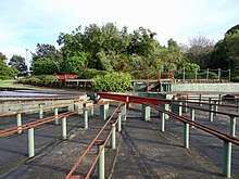
Minogue Park was first bought by Hamilton City Council in 1959, then extended in 1964, 1973 (Waterworld, dog exercise area, luge track and Hamilton Model Engineers Club), 1975 Rotokaeo Lake, 1979 (netball courts, BMX track and car park, and end of Walsh Street, 1992 NZR land west of Rotokaeo and in 2008. In September 1979 it was named after a former Mayor, Mike Minogue. In 2004 it was classified as a reserve under the Reserves Act (1977). There was a speedway until 1979, now this has been replaced by Minogue Park netball courts, a destination playground and a BMX track.[2] The Model Engineers Club moved to the park in 1983[10] and now has 1.6 km (0.99 mi) of miniature railway track,[11] a 1953 diesel shunter and the former Frankton signalbox.[12] The playground was modernised in 2015.[13] A cycleway is planned to link the playground with Nawton.[14]
Rotokaeo Lake
The Māori language-name Rotokaeo translates as Lake (roto) of freshwater mussels (kāeo). It also provided other food, such as koura, kokopu and tuna (eels), and plants such as raupō, mangemange and flax.[2] Electro-fishing in 2009 found catfish, goldfish and mosquitofish, as well as eels.[15]
The lake is supertrophic,[2] sometimes resulting in algal blooms.[16] An outlet weir keeps water at a maximum depth of 1.8 m (5 ft 11 in). The catchment is about 11 ha (27 acres), mainly stormwater from neighbouring streets. Rotokaeo now covers 3.1 ha (7.7 acres),[17] but once extended south into the area of the netball courts and BMX track, which was filled in for a rugby ground and then a stock car track. Before urbanisation the lake probably also had a larger area of peat bog.[2]
Before 2007 Mexican water lilies covered 86% of the lake, attracting many wading birds, but, after weed control, a 2008 survey found mallard, pukeko, coot, black shag, little black shag, little shag, black swan, Canada goose, Japanese snipe and dabchick.[2]
There is little submerged vegetation but kahikatea bush has been planted to the north and west, with baumea, kawakawa, mahoe, manuka, swamp millet and Hypolepsis distans, wheki, mata, turutu and silver ferns. The rest of the lake is surrounded by Carex virgata, kuta and makura sedges, Myriophyllum propinquum, pohuehue, flax, dwarf bog rush and swamp coprosma.[2] Weeds remaining include alder, arum lily , crack willow, grey willow, gorse, Mercer grass, pampas, reed sweet grass, yellow flag iris, parrot's feather and Japanese honeysuckle.[2]
See also
References
- "Traffic Counting Data" (PDF). Hamilton City Council. 2017.
- "Minogue Park OPERATIVE MANAGEMENT PLAN" (PDF). Hamilton City Council. October 2009.
- "2013 Census map QuickStats about a place". archive.stats.govt.nz. Retrieved 25 January 2019.
- "Waikato Expressway Te Rapa Section Opening History of the area" (PDF). NZTA. 2013.
- "Hamilton East Cemetery one hour Heritage Walk" (PDF). Hamilton City Council.
- "BUILT HERITAGE INVENTORY RECORD FORM" (PDF). HAMILTON CITY COUNCIL. 2012.
- "Workers' Dwelling". www.heritage.org.nz. Retrieved 26 January 2019.
- "Hamilton". hamilton.recollect.co.nz. Retrieved 25 January 2019.
- "Plan of Pt. Hamilton Borough and Frankton Borough". University of Waikato map collection. 1913.
- "Hamilton Model Engineers | About Us". www.hme.co.nz. Retrieved 26 January 2019.
- Cann, Ged. "Big boys' rail toys". New Zealand Herald. ISSN 1170-0777. Retrieved 25 January 2019.
- "Operative District Plan Volume 2 Historic Heritage" (PDF). Hamilton City Council. 18 October 2017.
- "Hamilton's latest 'destination playground' opens". Stuff. 18 August 2015. Retrieved 25 January 2019.
- "HAMILTON BIKING PLAN 2015 - 2045" (PDF). Hamilton City Council.
- Bell, Dudley G.; Brijs, Jeroen; Hicks, Brendan J. (2009). "Boat electrofishing survey of Lake Rotokaeo, Hamiton". Cite journal requires
|journal=(help) - "Some lakes and rivers already on the toxic list". Stuff. Retrieved 26 January 2019.
- "Waikato region shallow lakes management plan: Volume 2 3.1.1 Lake Rotokaeo (Forest Lake)" (PDF). Waikato Regional Council. 2014.