Ruakura
Ruakura is a semi-rural suburb of Hamilton City, in the Waikato region of New Zealand. The University of Waikato is nearby.
Ruakura | |
|---|---|
Suburb | |
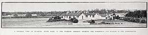 Ruakura State Farm in 1921 (homestead and stables in foreground) | |
| Country | New Zealand |
| Local authority | Hamilton, New Zealand |
| Electoral ward | Hamilton East |
| Established | 1888 |
| Population (2018 Census) | |
| • Total | 1,158 |
| Enderley | Fairview Downs | Eureka |
| Claudelands |
|
Newstead |
| Hamilton East | Hillcrest | Silverdale |
The area lies to the east of urban Hamilton and to the west of State Highway 1B (a variant of State Highway 1 which avoids the urban area).
Ruakura Agriculture Research Centre
Waikato Agricultural College and Model Farm was set up in 1888,[1] so that Ruakura is now synonymous with the Ruakura Agriculture Research Centre, the location of institutes such as AgResearch and Plant & Food Research. Areas of AgResearch's research at Ruakura include animal molecular biology (genomics and cloning), reproductive technologies, agricultural systems modelling, land management, dairy science, meat science, food processing technology and safety, and animal behaviour and welfare. Plant & Food Research's site in Hamilton is home to its blueberry nursery, its Bioengineering Group and its Food and Biological Chemistry laboratory. Work is also carried out on biological control agents. The Waikato region is a major contributor to New Zealand's agricultural-based economy, and Ruakura has an important role in that industry.
The Ruakura solution, a solution especially designed for pasture species, provides every nutrient necessary for plant growth and is appropriate for supporting growth of plants like maize, ryegrass, or white clover. The concentrations for each element in a full solution are shown below.[2]
- N 264 ppm
- K 238 ppm
- Ca 127 ppm
- P 40 ppm
- S 60 ppm
- Na 15 ppm
- Cl 9 ppm
- Mg 21 ppm
- B 0.5 ppm
- Fe 3.0 ppm
- Mn 0.5 ppm
- Zn 0.25 ppm
- Cu 0.04 ppm
- Mo 0.01 ppm
The Ruakura Agriculture Research Centre is on land owned by the Waikato Tainui, to whom it was returned by the Crown as part of their 1995 Waikato Raupatu Land Settlement.
The Waikato Regional Council included a majority of the land at Ruakura in the proposed Regional Policy Statement (PWRPS) as a future employment area. The Hamilton City Council Proposed District Plan gave effect to the PWRPS incorporating the Ruakura structure plan. The long term plan for Ruakura is that it will be New Zealand's largest integrated commercial and lifestyle development anchored by a freight and logistics hub. The project provides an unrivaled opportunity to drive the growth for businesses, as local and global trade continues to grow at an increasing rate. The vision is to build a real community at Ruakura with an exciting mix of high-quality work, live and play elements.
Demographics
In the 2018 census a new Ruakura area was created, covering the University and a rural area on the city fringe. It is 9.02 km2 (3.48 sq mi).[3] Up to 2013 Ruakura was part of the 8.22 km2 (3.17 sq mi) Newstead area, which covered a similar area, but excluded the University.[4] As shown below, the change resulted in a much larger, younger and poorer population in 2018 than previously and younger than the 37.4 years of the national average. 61.1% were European, 27.2% Asian and 13.7% Māori.[5] Only 3 people lived in meshblock 0955300, at the Research Centre, in 2013.[4]
| Population | Median income | |||||
|---|---|---|---|---|---|---|
| Year | Ruakura | Newstead | Median age | Households | Local | NZ |
| 2001 | 159 | 30.5 | 51 | $24,200 | $18,500 | |
| 2006 | 831 | 174 | 41.5 | 57 | $32,500 | $24,100 |
| 2013 | 900 | 216 | 36.2 | 81 | $33,800 | $27,900 |
| 2018 | 1,158 | 20.6 | 189 | $10,400 | $31,800 | |
Education
Tai Wananga is a co-educational state secondary school located in Ruakura.[6][7] It had a roll of 147 as of March 2020.[8]
Ruakura Junction railway station
Ruakura had a railway station from 1 October 1884 to 1 January 1967[9] at the junction of the East Coast Main Trunk and the Cambridge Branch. The branch had its first public train on 8 October 1884.[10] Ruakura was 8.17 km (5.08 mi) west of Eureka and 3.94 km (2.45 mi) east of Claudelands.[11] it was 2.57 km (1.60 mi) north of Mongaonui (or Mongonui), later renamed Newstead.[9] When the line opened, Ruakura station was described as an island in a swamp, with no road connection.[12] In 2020 reopening as a "passenger rail Metro Station" was put forward as a COVID-19 recovery scheme, as part of a $150m scheme to relay tracks to Cambridge.[13]
| Former adjoining stations | ||||
| Claudelands Line open, station closed |
East Coast Main Trunk New Zealand Railways Department |
Eureka Line open, station closed | ||
| Terminus | Cambridge Branch | Newstead Line open, station closed | ||
Employment area and Inland port
In 2016 approval was given to create an employment area, with an inland port, served by the railway and the Hamilton Bypass.[14] The development will cover 485 ha (1,200 acres), including a 31 ha (77 acres) inland port to the west of the Research Centre.[15] Opening is planned in 2021.[16]
Residential areas
The 2016 Structure Plan included residential development to the north and south of the employment areas.[17]
Greenhill Park
Greenhill Park is a medium density suburb at the north west of the development, begun in 2016,[18] It adjoins Fairview Downs. A 110kV transmission line was undergrounded in 2020 to make way for more housing.[19]
References
- "SUBMISSION ON VARIATION 1 RUAKURA" (PDF). Hamilton City Council. December 2015.
- Smith, G. S.; et al. (1983). "Comparison of nutrient solutions for growth of plants in sand culture". The New Phytologist. 94: 537–548. doi:10.1111/j.1469-8137.1983.tb04863.x. ISSN 1469-8137.
- "ArcGIS Web Application". statsnz.maps.arcgis.com. Retrieved 10 April 2020.
- "2013 Census map – QuickStats about a place". archive.stats.govt.nz. Retrieved 10 April 2020.
- "2018 Census place summaries". www.stats.govt.nz. Retrieved 10 April 2020.
- "Official School Website". ruakura.taiwananga.co.nz.
- "Ministry of Education School Profile". educationcounts.govt.nz. Ministry of Education.
- "Education Review Office Report". ero.govt.nz. Education Review Office.
- Scoble, Juliet. "Names & Opening & Closing Dates of Railway Stations in New Zealand 1863 to 2010" (PDF). Rail Heritage Trust of New Zealand.
- "Page 3 Advertisements Column 1 AUCKLAND STAR". paperspast.natlib.govt.nz. 3 October 1884. Retrieved 9 April 2020.
- Yonge, John Roger; Company, Quail Map (1993). New Zealand Railway and Tramway Atlas. Quail Map Company. ISBN 9780900609923.
- "The Opening. WAIKATO TIMES". paperspast.natlib.govt.nz. 9 October 1884. Retrieved 9 April 2020.
- "URBAN GROWTH PROGRAMME INITIATIVES" (PDF). Hamilton City Council. 3 April 2020.
- "History". Ruakura. Retrieved 10 April 2020.
- "Pictures reveal true size of Ruakura Inland Port". Stuff. Retrieved 10 April 2020.
- "Media Hub". Ruakura. Retrieved 10 April 2020.
- "Figure 2-14: Ruakura Structure Plan – Land Use" (PDF). Hamilton City Council. 21 October 2016.
- "Hearing to consider Variation 1 – Ruakura to the Hamilton City Council Proposed District Plan" (PDF). Hamilton City Council. 15 July 2016.
- "Developer spends $15m to put high voltage lines underground". Stuff. Retrieved 15 April 2020.
External links
- Ruakura website
- AgResearch website
- Information on AgResearch's campuses - AgResearch is a Crown Research Institute owned by the New Zealand Government.
- Street map of Ruakura from the Hamilton City Council site